Saturday, February 21, 2015

Seeking Salvation on the Sonoran Desert


Sunset Along Salt Creek Beach, Salton Sea
The ramshackle community of Niland, California bakes on the Sonoran Desert floor near the southeastern shore of the Salton Sea, a huge, shallow, and fetid lake whose salinity exceeds that of the Pacific Ocean. Although the lake has been termed “the crown jewel of avian biodiversity” because it functions as a major rest stop for migratory birds on the Pacific Flyway, there is very little obvious fauna here beyond the Tilapia carcasses and billions of barnacle shells that litter the beaches. On this President’s Day weekend, when throngs were crowding the roads to escape the urban jungle for one extra day, we found the lakeside campgrounds sitting largely unused.
 
With its stark aesthetic, substantial elbow room, endless warmth, and devil-may-care feeling, this is precisely the type of place that beckons to loners, introverts, drifters, vagabonds, anarchists, artists, eccentrics, desert rats, snowbirds, retirees, and non-conformists of all stripes. And beckon it has. Just east of Niland sits Slab City, an unsanctioned but strangely organized collection of squatters living in weathered mobile homes, beat-up campers, aging trailers, faded school buses, and other Mad-Max type structures. These new age wanderers, champions of self-reliance and unfiltered freedom, have chosen this chunk of BLM “wasteland” as their Eden far from the prying and restrictive norms of the madding herds.

Welcome to Slab City
Shoe Tree in Slab City


For Sale, $100

Enter Leonard Knight, a dreamer and Jesus freak who arrived in Slab City in the mid-1980s and never left. Starting in 1987 and continuing for the next 25 years or so, Leonard, driven by either demons or angels, created what has become known as Salvation Mountain, one of America’s truly unique and inspiring folk art sites. Splashed with bright colors, and adorned with folksy murals and Biblical quotations, Salvation Mountain is a three story mound of adobe, straw, and paint that rises from the creosote-studded desert to remind the world that “God is Love.”

Folk Artist Extraordinaire Leonard Knight
Salvation Mountain


Salvation Mountain Hogan


Salvation Mountain Detail


Hogan Interior


Jesus I'm a Sinner


Jesus Fire


Tree of Truths


God Is


God Is Love

The shadows were beginning to stretch long in the late afternoon sun as we drove north on Highway 111 along the eastern shore of the Salton Sea past Niland Marina County Park and the dilapidation that is Bombay Beach. Along the way, we made faces for the electronic spyware and the multitude of roadside cameras leading into the Immigration Check Point where we were quizzed about our citizenship and our other doings by a stern immigration official wearing a flak jacket. Having satisfactorily convinced the U. S. government that we were not undocumented Guatemalan immigrants that had snuck into the country illegally to steal low paying jobs with intolerable conditions from ambitious and hard-working citizens, we were permitted to proceed to Salt Creek Beach where we set up for the night along the shores of the Salton Sea.

The “campground” at Salt Creek Beach is paradoxically both unimpressive and impressive. To call it a campground is being charitable. In reality, it is an alkali bench sandwiched between the Salton Sea to the west and Highway 111 and the railroad tracks to the east. The north end of the campground is nothing more than a gravelly parking area with space for motorhomes and trailers (although there are no hook-ups); the south end is configured for primitive camping.

There is no natural shade at Salt Creek Beach. Being by the lakeshore it is buggy after the sun sets. And rumor has it that in the warmer summer months, the combined stench from the sea and the decaying Tilapia on its shores is intolerable. But the primitive camp area of Salt Creek has shade shelters and concrete picnic tables. It has spigots with potable water. It has surprisingly clean and odor-free bathrooms. And it has outdoor showers stalls so you can wash off the Sonoran sweat and dust. The $10 we spent for a night under the stars there was well worth it.


Tent Site at Salt Creek Beach
Salton Sea Sunset


Salton Sea Birds


Tilapia Carcass


Barnacle "Sand"


White Pelican in Flight


Fading Light Over Salton Sea


Darkness Descending on the Sea


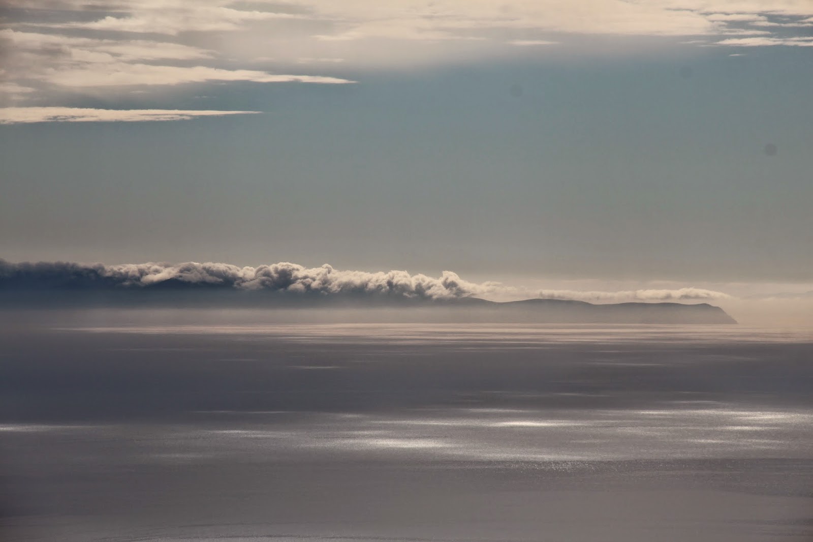
Salton City from Salt Creek Beach


Dawn at the Salton Sea

After cowboy coffee the following morning, we packed our backpacks and drove north toward the high desert. The National Park Service was waiving the entry fee to our national parks over the long holiday weekend so we decided to take advantage of the winter-that-never-was and backpack into Joshua Tree National Park for a night under the stars.

The Keys West back-country registration board and parking area sits at the southern terminus of the Boy Scout Trail, a heavily used 7 mile hiking trail that originates near the Indian Cove campground on the northern fringes of the park. Early Saturday afternoon of the President’s Day weekend, it was such a popular spot that finding a place to leave a car for the night was a bit of a challenge. Of course, most folks use the trailhead as a launching pad for day hikes into the Wonderland of Rocks. But on this weekend, there was a steady stream of backpackers sharing the trail with us as we made our way north in search of the perfect tent site.

The Wonderland of Rocks, which sits on the east side of the Boy Scout Trail, is a 12 square mile jumble of granite outcroppings, hidden corridors, sandy washes, stately Joshua Trees, and secret water holes. As a result, it holds all the best primitive camp spots along the Boy Scout Trail. Unfortunately, none of these spots are legal as the Wonderland is day use only. That little technicality, however, deterred absolutely no one on the day we visited. Backpackers poured into the Wonderland and set up camp where they damn well pleased.

Not far up the path, we found a flat spot hidden from the main trail and protected from the wind with expansive views into the Wonderland.  Believing that it was conceivable that we might find another comparable spot, but certainly nothing superior, we laid claim to the site before others could and set down stakes for the night. Then we went exploring while the sun still hung high in the sky.

As the day came to a close, and the light began to dim, we scaled a rocky precipice and watched while the desert rock turned pink, then lavender, and ultimately black as the sun disappeared over the western horizon. With the sun gone, the temperatures dropped rapidly into the mid-30s (something the forecast unsurprisingly neglected to predict) and we spent a good portion of the night fighting off the desert chill in our fly-less tent.


View West toward San Gorgonio
Joshua Tree Tent Site


Colorful Cactus


Late Afternoon Shadows


Fading Light on Joshua Trees


Sunset Over San Gorgonio


Sunset Over the Wonderland of Rocks


Wonderland of Rocks


Last Light over the Wonderland


Sunset


Tent Under the Stars

Early the next morning, the sun burst over the eastern ridge and made us warm again as we lounged like lizards on the rocks. We made coffee, talked about the awesomeness of the desert, plotted our next adventure, and otherwise lingered as long as we could to avoid leaving.

Back at Keys West, the situation was total pandemonium. Cars clogged the parking area. A line snaked out of the bathroom. Folks clogged the trailhead understandably wanting a piece of what we just experienced. We loaded our gear in the car and left the madding crowds of Joshua Tree for the madding crowds of Los Angeles.

On the way back, we made a pilgrimage to the Cabazon Dinosaurs which of course always reminds me of Pee Wee’s Big Adventure. As we looked up at the T-Rex where Pee Wee and Simone supposedly watched the sunrise, I thought to myself “We should really do this more often, but…” It was at that moment that I thought I heard Pee Wee reply: “But what? Everyone I know has a big ‘But…’ C’mon, let’s talk about ‘your’ big ‘But.’”


T-Rex at Cabazon
Brontosaurus Close Up


Tuesday, February 10, 2015

The Pratt Trail to Nordhoff Peak

Nordhoff Peak Abandoned Fire Lookout
Nordhoff Peak in the Los Padres National Forest is the high point of a rugged, mountainous ridge that forms a rampart along the northern border of the Ojai Valley. The peak, adorned with the remnants of a now abandoned fire lookout, stands sentinel high above the village of Ojai some 3500 feet below. Originally named "Nordhoff" after author Charles Nordhoff when the town was first established in 1874, the town's name was ultimately changed to Ojai in 1917. The name Ojai derives from the Indian word "Awhai" meaning "moon" in the language of the Chumash who once inhabited the valley.


California Man Root Growing Along Pratt Trail


Pratt Trail Winding Through Lower Steward Canyon


Wild Hyacinth is Abundant Along the Trail-
There are two principal routes to the summit of Nordhoff Peak from the Ojai Valley: the Gridley Trail and the Pratt Trail. The latter, an 11 mile or so round trip jaunt, begins at a small forest service parking area along the upper reaches of Signal Street. The initial rock-strewn portion of the trail winds its way up lower Stewart Canyon through private property until the path reaches a gate at the terminus of the Cozy Dell Fire Road. Beyond the gate, a footpath branches off to the left and parallels the streambed before re-joining the Fire Road a short distance later near the junction with Fuel Break Road. This entire stretch of trail is verdant, luxurious, and exploding with flora particularly after the drenching winter rains.


Signage at Junction of Foothill and Pratt Trails


Luxuriant Greenery
From this point, the dirt road climbs steadily north and then west to a saddle overlooking Cozy Dell Canyon and the Matilija. To the east, views of the upper Ojai Valley begin to open up. Beyond the saddle, you abandon the Fire Road once again in favor of a well established foot path that ascends relentlessly up the western wall of Stewart Canyon.  


View West at Cozy Dell Saddle
View East Toward the Upper Ojai Valley


Trail Signage at Cozy Dell Saddle
The initial climb out of the Cozy Dell saddle is on a south facing, chaparral-covered slope that is warm in the winter and which would be scorching in the summer. However, the trail eventually contours the ridgeline into the cool shade of the east-facing slope until the trail crosses over onto the eastern slope of upper Cozy Dell Canyon where views open up south to Lake Casitas and the Channel Islands. Midway between these two points, a short spur trail descends to Valley View trail camp which is somewhat of a misnomer depending upon the valley you are supposed to be viewing.

Beautiful Purple Nightshade
Anacapa Island Floating in the Santa Barbara Channel
After a sustained climb, the path ultimately tops out on the Nordhoff Ridge which affords dramatic and panoramic views north into the Sespe Wilderness, west into the Matilija Wilderness, and south toward the Santa Barbara Channel. To the east sits Nordhoff Peak, the summit of which is visible from the trail's crest.

Piedra Blanca and the Pine Mountain Ridgeline from Nordhoff Ridge

Clouds Descending Into Murietta Canyon

Nordhoff Peak Fire Lookout from Nordhoff Road at Pratt Trail

Ominous Clouds Hanging Above Lake Casitas
From the point where the Pratt Trail intersects the Nordhoff Ridge Road, it is approximately another mile of easy walking to the summit of Nordhoff Peak. The views along the ridgeline are dramatic and the place has a primal and remote feel to it that is sometimes absent in the mountains of Southern California.  At the summit, there is a picnic table and a fire ring directly beneath the abandoned lookout tower which you can climb for better views of the Piedra Blanca formation nestled in the Sespe River drainage to the north. There are also two survey markers adjacent to the tower embedded in what looks like concrete footings.

Fog Rolling In Over Nordhoff Peak
Clouds Enveloping Piedra Blanca

Visitor Atop Abandoned Nordhoff Peak Fire Lookout

One of Two Nordhoff Peak Survey Markers
There are two return trip options. You can either retrace your steps back down the Pratt Trail or you can continue east another mile along the Nordhoff Ridge Road and descend the Gridley Canyon Trail which will ultimately deposit you onto Gridley Road in Ojai. Although I did not go this way, it appears that one could easily loop back to the Pratt Trail trailhead by a short traverse west along Shelf Road once back in the Ojai foothills.


Chaparral Currant on the Descent (ID courtesy of Matt Maxon)


Sunday, February 1, 2015

A Hot Time on Cold Spring

On Friday I played hooky to go play in the local mountains with my daughter Maddie on what turned out to be a remarkably warm and humid winter day. We decided to go coastal to avoid the rain that was falling inland and headed for the Santa Barbara front range to get the best that both the mountains and the beach could offer. The specific object of our desire was Montecito Peak by way of the historic Cold Spring Trail.

Sun Dappled Cold Spring Trail
From East Mountain Drive, the Cold Spring Trail ascends Cold Spring Canyon a short distance before it splits into east and west forks. The path to Montecito Peak follows the creek up the East Fork before climbing out of the canyon to a vista point separating Cold Spring and Hot Springs Canyon. The trail then continues up the rocky south side of Montecito Peak to a steep spur trail leading to the summit. Ultimately, the main trail intersects the Camino Cielo at the mountain crest separating the front country from the back country. From the Camino Cielo, the Cold Spring Trail drops about 1000 feet down the backside to Forbush Flat (named for Fred Forbush who built a cabin and planted an apple orchard along Gidney Creek in 1910). It then makes another 1000 foot drop to Gibraltar Reservoir and the Santa Ynez River far below.

The Cold Spring Trail is historically significant as it was once one of the prime routes leading from Montecito into the upper Santa Ynez drainage, along Mono Creek, over the Puerto Suelo in the San Rafael Range, and then into the Cuyama Valley. But the trail today up the East Fork is apparently not in the same location as the original trail. According to the Santa Barbara Trails Council:

"Originally, though, the main route was up the West Fork... Passing the site of the Cold Springs water tunnel, bored into the mountain on land donated by Eugene Sheffield, the trail led up to a 300-foot waterfall on the West Fork. There it switchbacked around it on the west and then proceeded by a large pointed rock at the top of the falls, named “The Pinnacle” by E.M. Heath in his 1904 book, A Guide to Rides and Drives in Santa Barbara. From there, it continued up the creek bottom through a narrows, then began to wind its way up shale slopes to the crest, where it crossed over and down the head of Gidney Creek (Forbush Flats) to the Santa Ynez River.

When the Santa Ynez Forest Reserve was created in 1899 the Cold Springs Trail was improved by the forest rangers. Rather than having to split their efforts on trails up each branch of Cold Springs Creek, they decided to concentrate on the East Fork.

“It is considered advisable,” Forest Inspector Louis A. Barrett wrote to his superiors in Washington in 1905, “to have one well built main trail crossing the Reserve from the Coast to the desert side and one half of the field force will be at work on this trail all the spring.”

Felling (sic) that the trail around the falls and up the shale slopes would be too difficult to maintain, the Forest Service began work on the East Fork. With these improvements, the route up this watershed became known as the Cold Springs Trail, and because of them, became the main route over the mountain wall."

Note that the excerpt above refers to the trail as the "Cold Springs" while I refer to it in the singular, "Cold Spring." There appears to be some confusion about the correct nomenclature. Even the signage at the trail head uses both names on the exact same sign-post. Most folks it seems casually refer to the trail and the canyon it ascends as "Cold Springs." But the topographic maps and other sources I have consulted identify the trail and canyon as "Cold Spring" and I believe that is the correct name.


Cold Spring Trail Just Beyond the Trailhead
Water Cascades Into a Pool in Cold Spring Canyon

Cold Spring Creek Deep in the Canyon

With the recent rains, there was still water flowing in the creek. The surrounding canyon was an orgy of greenery and blooms. In addition to a proliferation of colorful wildflowers and verdant ferns, clovers, and grasses, the canyon was thriving with poison oak. The latter can pretty much be avoided if you stick to the main trail and stay observant. 

Bermuda Buttercup (Non-Native)
Wood Fern (Native)


Perfect Vinca in Cold Spring Canyon (Non-Native)


Need Assistance with this Identification - Looks like Arugula


Evil Devil Bush - This is Quite Common in the Canyon
While you are in the canyon bottoms, views toward the coast are limited. But once the trail climbs out of the canyon to a promontory to the immediate east, the terrain opens up and you get unobstructed views of Santa Barbara and the Channel Islands off in the distance.

Cabrillo Beach and Stearns Warf from Saddle
Anacapa Island in the Santa Barbara Channel

From this point, the trail begins climbing Montecito's south facing ridgeline through the dense and aromatic chaparral that we all know and love so well. The route becomes rocky here and because of the south-facing orientation, gets quite warm. A couple of out-of-place Eucalyptus trees at about the 2500 foot contour provide some shade and additional views before the final push to the summit.


Ridgeline Leading to Pt. 3440 (I think)


Platforms in the Santa Barbara Channel


Clouds Boiling Over Santa Rosa Island


View from Near the Eucalyptus Trees


The Eucalyptus "Grove" Below Montecito Peak
Beyond the Eucalyptus tree rest stop, the trail wends its way around to the north slope of Montecito Peak where a steep and well-defined use trail takes you to the summit which offers panoramic views of the Gold Coast and the Santa Barbara channel, a rocky prominence from which to enjoy it, and the intoxicating aroma of blooming Greenbark ceanothus.

The Channel Islands from Montecito Peak
Santa Barbara from Montecito Peak


View South Toward Carpinteria from Montecito's Summit


Lonely Anacapa Island in the Channel Haze


These are Modern Times We're Livin' In