Sunday, April 24, 2016

Counting Peaks Around Monte Cristo

The Iron Hiker on Monte Cristo Ridge
The plan was to meet Keith "the Iron Hiker" Winston at 6:30 a.m. at the entrance to Monte Cristo Campground in the upper reaches of Mill Creek Canyon to tackle a 4 peak loop that we had both been eyeing for some time. That loop involved a mostly cross-country, counter-clockwise route that would take us to the summit of Iron Mountain #3, Round Top, Granite Mountain, and Rabbit Peak (with the provisional "peak" Monte Cristo thrown in for good measure). Since Keith was coming from south Orange County and I was coming from eastern Ventura County, I figured I'd have no trouble beating him to our rendezvous. But of course the best laid plans of mice and men were foiled when I couldn't locate some of my gear that morning, had to stop for gas, and then misjudged how long it would take me to get to Monte Cristo. When I finally arrived at our pre-ordained meeting spot some 30 minutes late, Keith was preparing to walk off without me, figuring that I had probably died in the zombie apocalypse (or maybe that I had just stood him up).

Not wanting to delay our adventure any longer, I scrambled to get my act together and then off we went. It was a gorgeous, cloudless morning with the early sun throwing shadows into the crevices and folds of the surrounding canyons. At the entrance to the campground after crossing now dry Mill Creek, we entered a small drainage which afforded us easy access to the Monte Cristo Ridge.

Ascending the Ridge from Monte Cristo Campground
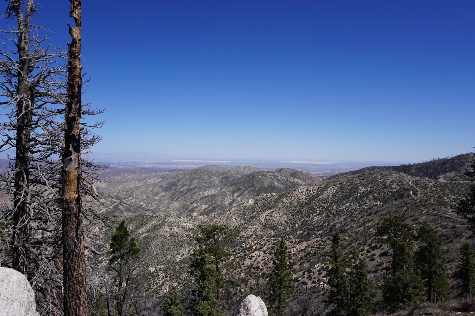
View North from the Monte Cristo Ridge
View South from the Monte Cristo Ridge
The ridge climbs moderately to a high point (Monte Cristo) before dropping to a saddle and then regaining some elevation before intersecting the fire road that contours around the western face of Iron #3. The brush was minimal here and travel was easy. This was a common theme for the day - none of the ridges we walked involved any real bush-whacking. From Monte Cristo we could easily see the rest of the circuit we had planned for the day.

On gaining the fire road, we tacked right (south) and followed it to the point where Iron's southwest ridge intersected the road. Here the road cut was low which permitted us to jump on the ridgeline and begin the push for Iron's summit. A short, stout climb later and we were atop Iron #3. On top we found a triangular post and a soggy register, but no benchmark. Views here of the backside of the front range, particularly Strawberry's north face, were impressive. Looking northeast, the steep and somewhat intimidating ridge route to Round Top was plainly visible.

The Circuit - Iron #3 Out of Frame to the Right
View South from the Summit of Iron #3
The Route to Round Top as Seen from Iron #3
The North Face of Strawberry Peak - Still Waiting for a TR from Taco About This
After some water and a snack, we dropped off the north side of Iron, crossed a fire road at the head of what the topos call Lynx Gulch (the topos also show the Gold Bar Mine in the bottom of the gulch), and began the 1,600 foot climb up Round Top. This is the crux of the route which follows a old firebreak up and over a couple of bumps (false summits) before topping out on the broad, rounded summit of Round Top. The climb along this ridge is steep in places, but the brush was minimal, footing was good, and use trails abound. Views from atop Round Top are quite exceptional even though the summit itself is somewhat uninspiring. To the east you can see Mt. Waterman, the Twin Peaks, Mt. Hilyer, and the entire Chilao area. To the north, Granite and Pacifico Mountains loom large. To the west the Gleason Ridge stands out. And looking sound affords a good look into the entire Upper Tujunga drainage. 

Once atop Round Top's exposed summit, the winds really began to pick up, so we quickly refueled and then made haste for Granite Mountain by way of the Round Top Truck Road which we followed north for a short distance to the toe of Granite's southeast ridge. A mellow ascent through some light brush and dead fall led us to the big, broad, burned-out summit of Granite which is appropriately dotted with a number of large, granite outcroppings. Here, like Iron, we found a damp summit register, but no benchmark. The winds were now howling at a sustained 30-40 mph so we huddled behind some rocks while we ate lunch, appreciating the fact that the next leg to Rabbit Peak was almost all downhill.   

The Steep Firebreak Leading to Round Top
Cross-Canyon View Toward the Gleason Ridge
Over-the-Shoulder Look of the Ridge Leading to Roundtop - Iron #3 Center-Left
Keith Contemplating the Final Push to Round Top - There are a Couple of Bumps Along the Ridge
Into the Light
Pacifico Mountain from Round Top
Granite Mountain from Round Top
View East from Round Top - Hillyer, Wintson (I think), Waterman, and the Twins
Mt. Gleason from the Fire Road to Granite
Granite from the Fire Road from Round Top
The Iron Hiker Atop Some Granite on Granite
High Desert View from Granite's Summit
Remnants of the Station Fire Atop Granite - 7 Years and Counting
The southwest ridge off of Granite is obvious and we followed it down to a saddle before making the final climb of the day to the top of Rabbit Peak. Once again, the brush was minimal and there was a fairly obvious use trail along the entire ridgeline. On the summit of Rabbit, the winds really died down so we lingered a bit after signing the register to appreciate the moment, the warmth of the day, and the big, brilliant azure sky.

From Rabbit, we descended the steep and loose south ridge to a jumping off spot which deposited us onto the fire road in the canyon bottom near the Black Cargo Mine. Hindsight being what it is, we should have just followed the ridge to its logical terminus further down canyon, but we hadn't done our homework and so were not aware that was even an option. In the canyon, we walked the fireroad adjacent to Monte Cristo Creek (which still had some flow) back to our starting point at the entrance to Monte Cristo Campground.

It is worth noting that this route can be done in a clockwise direction instead of the counter-clockwise variation that we followed. In fact, Cucamonga Man and Cecelia recently completed the circuit in that direction. But after descending the ridgelines off of Rabbit and Granite, the counter-clockwise variation that we took appears to me to be the better option.

More info and pics about this route can be found on Iron Hiker's fine blog here.

Our Route Down the Southwest Ridge - Rabbit Peak in the Center
The Ridge Route Off  Granite as Seen from Rabbit
Mt. Gleason from Rabbit's Summit
Keith Taking in the View Atop Rabbit Peak

Tuesday, March 22, 2016

Santa Paula Canyon: Be One With Nature

The Chapel Tower at Thomas Aquinas College
Just north of Steckel Park, where the locals gather on Sunday afternoons to bond and drink bad beer beneath the ancient Oaks and Sycamore that flank Highway 150, Santa Paula Creek spills into the flood plain from the remote depths of the Los Padres National Forest. Although the creek’s precise location is not immediately obvious to the casual observer, masked as it is by lush campus of Thomas Aquinas College, its existence, and the means to access it, are anything but a secret. In fact, it’s probably not too much of an over-statement to say that Santa Paula Canyon, and the creek that pulses through it, have attained almost legendary status amount Ventura County hikers and outdoor enthusiasts of all stripes.

Like other immensely popular destinations, water is the magnetic draw here. Not just water that trickles along a rocky streambed and collects in stagnant and ephemeral pools. But clear blue water that in the right season gushes forth from the folds and creases of the mountainside to furiously tumble and cascade over the stoney cliff faces into swimming pool-sized “punch bowls” below.
These punch bowls, and the falls that continually feed them, are very special and unique places in this otherwise arid, waterless landscape. But water, particularly if one can swim in it, is an attractive nuisance that always seems to draw a certain element. And that element always finds a way to make a complete mockery of the “leave no trace” ethos that the rest of us try damn hard to practice.


Santa Paula Creek Flowing Muddy Brown
Be One With Nature by Marking it Up
Trial Markings Just in Case You're Confused About the Way Forward Here
Reflections in a Trail-side Pool
The Forested Path Up the Canyon
Orange
Yellow
Cream
Down Canyon
Geology
Up Canyon
These destructive folks about whom I speak know all about Santa Paula Creek. And they have memorialized their visits to this canyon in bright red, blue, green, and purple spray-paint that is visible on virtually every tree, branch, and rock along the trial that weaves its way up the creek bed to the lower falls. Most of the marks are just tags left by punks who feel the need to mark their territory like the animals that they are. Some of it, however, is more philosophical like the graffiti ironically urging others on the trail to “be one with nature.” The canyon walls beneath the pool at the first falls too are plastered with unsightly graffiti while beer bottles and other trash litter the canyon bottom. On the day I visited, I rounded a bend in the trail to come face-to-face with a “gentleman” whose shorts were around his ankles as he dropped a dookie trailside with absolutely no shame or regret.

But it is possible to look past the spray paint and the trash and the dookies and the words of the philosopher kings. And you should. Because despite all of it, this is still damn compelling and wild country that is worth the visit. There are very few local places that I can think of that rival it. Tar Creek before the Forest Service closed it off probably qualifies. Matilija Falls if you can get there without raising the ire of the cranky landowner over whose property the path supposedly crosses. Perhaps a few spots along the Sespe. Maybe the Fishbowls in a good water year before they silted up. But the list is short and the chance of reaching your desired destination can be dubious. So I’ll go to Santa Paula Canyon again despite the negatives. I’ll go to see the canyon. I’ll go to experience the blessed water while it’s still around. I’ll go to sit beneath the falls and feel the cool spray. I’ll go on an uncrowded day when the skies are threatening or the temperatures are cool to listen to the silence ricochet off of the walls of the gorge. And I’ll turn a blind eye and ear to the rest.

Canyon Art
Lower Falls
Lower Falls and Pool
Welcome to the Jungle

Saturday, March 5, 2016

No Thrill on Thrall: High Desert Trail to Burkhart Saddle

Looking Toward the Burkhart Saddle Up the Cruthers Creek Drainage
There are essentially two established routes to the summit of Will Thrall Peak: the Burkhart Trail from the south out of Buckhorn Campground (a variation of which involves dropping into Cooper Canyon on the PCT from Cloudburst Summit along the Angeles Crest Highway), and the High Desert Trail from the north out of the Devil’s Punchbowl. You can also get to Will Thrall from Mt. Williamson by way of a cross-country jaunt across Pleasant View Ridge to the summit of Pallet Mountain and then down to the Burkhart Saddle where all three of these routes intersect. And I just discovered courtesy of Cucamonga Man that you can also access Will Thrall by way of a cross-country route via Alimony Road (4N15) in Juniper Hills. Having previously experienced the cross-country route from Mt. Williamson with an exit at Buckhorn, a couple of friends and me decided last Sunday to make an early season attempt on Will Thrall by way of the High Desert route from the north.

This route starts from the parking lot for the Devil’s Punchbowl Natural Area which is managed by the Los Angeles County Department of Parks and Recreation. From here, the trail (which initially follows a fire road) climbs gently south for approximately ¾ mile where it intersects with the High Desert Trail which runs in an east-west orientation along the northern foothills of the Pleasant View Ridge. Going east here will take you out to the Devil’s Chair and ultimately South Fork Campground. Traveling west will take you to Cruthers Creek which drains the narrow canyon leading to the Burkhart Saddle.

We tacked west here and began the 3 mile walk toward the mouth of Cruthers Creek Canyon enjoying the shade, the Mojave views, and the gigantic Manzanita along the way. The terrain here is mellow and trekking is easy, primarily because you’re continually losing elevation all the way to Cruthers Creek. You’ll realize just how much elevation you’re losing on your way back out.

The High Desert Trail Just Beyond the Split from Devil's Punchbowl
The High Desert from the High Desert Trail
Descending Into Cruthers Creek
Signage at the Base of  Cruthers Creek
Colorful Rock Formations
At Cruthers Creek, the track turns south, crosses the stream (where we found water flowing), and begins the steady climb toward Burkhart Saddle some 3+ miles up the canyon. A dirt road from the north intersects the trail in the canyon bottom here, but it traverses private property and is secured by a locked gate. That is unfortunate because the road provides direct access to the canyon and would trim some miles off the overall trip if it was available for use by hiker trash. Not that miles are necessarily a bad thing, but whether having to traipse them is desirable or not I suppose depends upon your objective.

Out of the canyon, the trail initially climbs northward up the exposed western slope of the canyon before switching back south at a point along an obvious ridge. The ascent here would be uncomfortably warm on a mid-summer day. Shortly beyond this point, the trail crosses back over to the western slope of the canyon and then continues south well below the ascending ridgeline. Mileage markers, which I understand to be measured from Buckhorn Campground, dot the trail which is useful in terms of tracking your progress.

Cool Cruthers Creek
Climbing Out of the Canyon
Looking Back 
Desert View from Higher Up
From Cruthers Creek all the way to the Burkhart Saddle is a sustained climb. This climb is never steep, but it is unrelenting with few level stretches and fewer suitable spots to pitch a tent for the night. If I was a PCT through-hikers who opted for this official detour around the Williamson Rock closure area, I would probably try to plan my route to avoid spending the night along this stretch of trail.

As the path climbs deeper into the canyon and the air thins, the character of the surroundings changes. The canyon narrows, the slopes steepen considerably, and the flora thins. Manzanita, sage, and chaparral give way to evergreens. In several places, the track crosses scree slopes which could be dicey in winter conditions, but on our visit, the path was devoid of snow for most of way and trail conditions were excellent. Tip of the hat to the fine folks who maintain our trails and keep them passable.

Trail Ascending the Steep Western Wall of the Canyon
Trail Conditions
The path wasn't bereft of snow the entire way, however. At approximately the 6,000 foot level, roughly 1/2 mile from Burkhart Saddle (between mileage markers 6 and 5) we encountered snow where the path takes a hard bend and tacks east. It wasn't much snow, but it covered ice and sat on an off-camber stretch of the trail that was exposed. A tumble here could definitely get you a helicopter ride out of the canyon. My friend gingerly attempted to start across the snowy section and immediately slipped in his trail runners. We then tested the shoulder and it promptly gave way. Finally, we attempted to skirt this section of the trail by going high, but the slope was so steep and loose, and the rock so crumbly, that ultimately we abandoned that option as folly. So we contended ourselves with sitting on a nearby log in the snow, having a bite to eat, enjoying the amazing moment, and living another day to tell the story.

Dangerous Patch
Your Fate if You Slip Here
The Sketchy Part of the Trail from Down Canyon
After absorbing as much of the mountains as we could, we turned tail and retraced our steps back to Devil's Punchbowl. As mentioned, the return trip is all downhill except for the climb back out of Cruthers Creek which my device measured at roughly 800 feet from the creek-bottom to the high point along the High Desert Trail. My device measured total mileage and gain for the day at roughly 13.9 miles and 3,750 feet of elevation gain.

As for my hoped-for date with Will Thrall, it was disappointing that it was cancelled, but it will happen at some stage. In the meantime, this was a really nice tease by a less visited section of the San Gabriels that just enhanced the attractiveness of the object of my mountainous desires.

Almost Back to Devil's Punchbowl
The Punchbowl