Sunday, April 23, 2017

Becoming Less of a Douche in Trail Canyon


Now those memories come back to haunt me
they haunt me like a curse
Is a dream a lie if it don't come true
Or is it something worse
that sends me down to the river
though I know the river is dry
That sends me down to the river tonight
Down to the river my baby and I
Oh down to the river we ride.
~Bruce Springsteen, The River

I've been wanting to get up Trail Canyon for quite awhile now. Initially, I was interested in the canyon as the most direct route to Condor Peak which I have yet to visit. Then, after the Station Fire ravaged the area and Mother Nature reclaimed the upper-most stretches of the canyon making it virtually impassable to most mortals, I tempered my expectations, focusing instead on visiting the ever-popular falls and Tom Lucas trail camp. The problem was that every time I made an effort to satisfy my curiosity and actually hike the canyon, I was stymied mostly by myself.

I once had a bad experience at the entrance to Gold Creek Road while I was out for the day exploring Mt. McKinley - vandals broke into my car by smashing my passenger side window - so the trailhead holds some residual bad juju for me. That kept me away for a spell, always looking for places to explore other than Trail Canyon. But then the skies finally opened up this winter and let loose enough rain to allow the governor to declare the drought "over." And suddenly the prospect of seeing real water cascading over the falls swept aside any thoughts of another break-in.

The problem became other obstacles, real and imagined, that kept running interference. First, I tried to visit too soon after the rains when the trail bed was a sloppy mess and the creek a raging torrent. Then, what I'll call my "trail elitism" took over and I wasted another few weeks going other places while the flow in the local creeks slowly began to die. This "trail elitism" involved my refusal to explore the canyon if there were more than a few cars parked at the trailhead (ironically, this compulsion to have the trail, and the trailhead, to myself probably contributed to my previous episode involving vandals). So when I approached the entrance to Trail Canyon on my next planned visit and found Big Tujunga Canyon Road clogged with cars and hikers at Gold Creek, I just kept driving. In fact, all I ended up doing was driving that day. I did the exact same thing on a subsequent visit, although on that occasion, I actually ended up hiking another route instead of just burning fuel.

But this past weekend, I set aside my trail elitism in favor of a more hiking-friendly, egalitarianism. So when I arrived at Gold Creek and the entrance to Trail Canyon this time and found it predictably over-flowing with automobiles once again, I didn't keep driving. Instead, I stopped, got out of the car, and began hiking.

As expected, I encountered a fair number of hikers on my way up this justly popular trail. Most of them were in groups and going in the opposite direction as me. No one was overtly unfriendly, but I did get forced to the exposed, downslope side of the narrow trail in several instances by descending clumps of spandex-clad hikers who mostly didn't adhere to the generally accepted tenets of trail etiquette. In my experience, that's not an uncommon phenomenon on trails that are popular with the mall-walking masses. It's not a malicious thing, I just don't think they are sensitive to the potential danger they might be putting other hikers in.

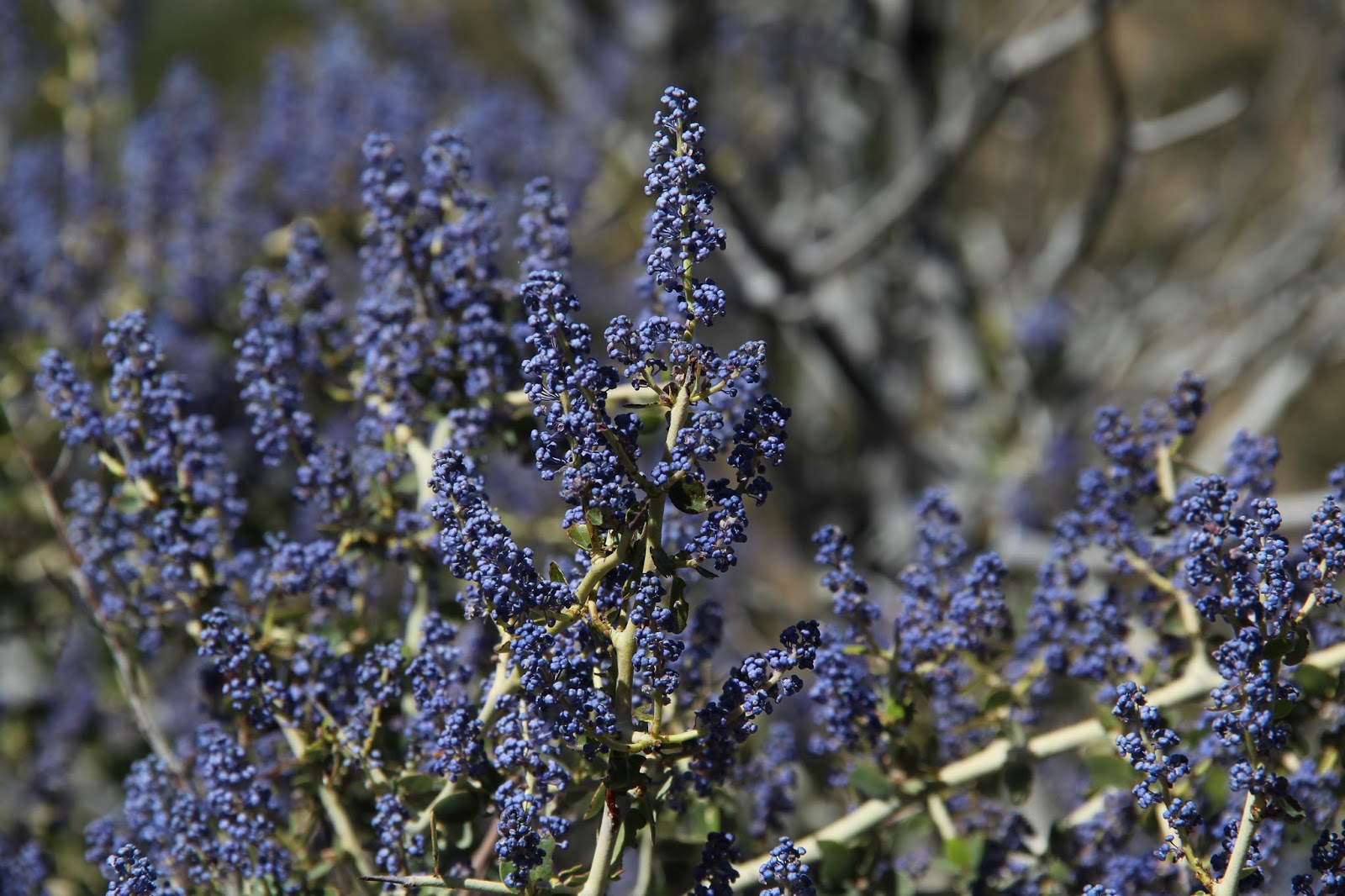
Trail Canyon is classic front-side, scrub-dominated western San Gabriels. Yucca, manzanita, ceanothus, scrub oak, and other native fauna typical of chaparral communities dominate here. Poison Oak is plentiful near and along the stream bed. The canyon's north side is bounded by the western slopes of Condor Peak and its steep and rocky western ridge. Pt. 3520 dramatically hangs over the canyon and was a constant companion as I climbed.

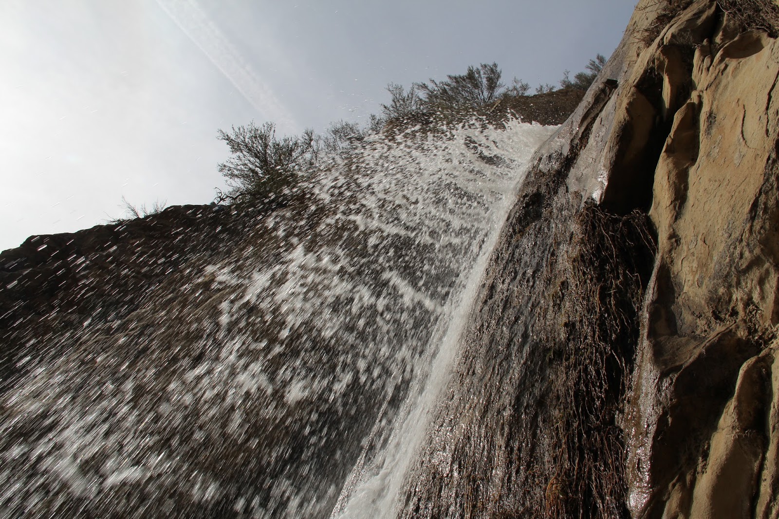
Just south of where McKinley Canyon comes in from the left and Condor Canyon comes in from the right, the path horseshoes around a ridgeline and the falls come into view. Fortunately, the creek still had a decent amount of flow it in so that falls were still falling. My self-imposed delay tactics hadn't prevented me from experiencing this ephemeral beauty after all. Down the very steep, rope-assisted use path and I was standing at the base of the falls.

There were a few folks milling about in the cool alcove where the stream from above cascades into a small pool. To my pleasant surprise, the trash and graffiti that is the typical hallmark of well-visited spots like this was absent. Since the day was warm, I promptly dropped my pack, stripped off my shirt and shoes, and made a spectacle of myself by standing directly beneath the cool, luxurious water of the falls. No one said anything, but I'm sure the sight of an old guy with a slight paunch and a fluorescent-light tan was an ugly sight that my fellow hikers would have preferred to not witness.

Now soggy but refreshed, I continued up the canyon where the number of other hikers I encountered dwindled to zero. My plan was to visit Tom Lucas trail camp before turning around and retracing my steps back to the trailhead. I understand from numerous anecdotal sources that beyond Tom Lucas, the trail to the ridgeline high above is an obliterated and difficult-to-navigate thrash-fest.

As I continued up canyon, the path narrowed some and brush began to intrude onto the trail. Just below Tom Lucas, I encountered a stretch where Poison Oak encroached from both sides. It was certainly passable, but I had just recovered from a bout of poisoning by Poison Oak and I wasn't terribly interested in a relapse so soon. So I chose to end my day here, opting instead to retreat down-canyon to a pleasant spot along the creek where I enjoyed snacks with a view.

Back at the trailhead, I found all my car windows fully intact. So not only did I overcome my own "I can't share the trail with anyone else" douchiness this day, but I exorcised the lingering bad vibes I had about this place from my previous experiences. A successful day. 

First Glimpse of the Beautiful Falls

The Falls Showing Off 

Stand Here for Best Results

Just Before Stepping Under the Torrent

Upper Trail Canyon

Lunch with a View

Dramatic Rocky Prominence ~ Pt. 3520 I Believe

View Down Canyon

Over the Shoulder View on the Descent

Beautiful, but Invasive

Big Tujunga Canyon


Thursday, April 13, 2017

Up, Over, and Around Strawberry Peak

Strawberry Peak from Colby Canyon
Start a new chapter
I find what I'm after
Is changing every day
The change of the season
Is enough of  reason
To want to get away.
~Rush, Fly by Night

Early October, 2005. My first foray into the San Gabriels. A friend and I drove up the Angeles Crest with mountain bikes strapped to the car. Into the unknown. We stopped at Clear Creek, unloaded our gear, and began to ride. Our 16.5 mile route took us up the Josephine Fire Road (2N64), over to the junction with the Colby Canyon trail, onto the spectacular single-track that descends to Strawberry Portrero, out and up the slow grind to the Lawlor saddle, around and down Lawlor's southern flank to Red Box, onto the wondrous Gabrieleno Trail down to Switzer, and then up the short, steep, and miserable pavement climb to Clear Creek. We thought we were all that until a fellow bi-pedal easily pedaled past us on a fully rigid, skinny-tired cyclocross bike as we inched our way up the Josephine Fire Road. As we were San Gabriel newbs, he rode with us for a spell to act as our navigator, sensing perhaps that we were search and rescue candidates in the making. But at the Lawlor saddle, he finally left us after causally drinking a beer he pulled from his pack, exasperated I'm sure with our snail's pace.

That was kind of a watershed moment for me in terms of the San Gabriel Mountains. It opened my eyes to the vastness, the ruggedness, the immensity, and the sublimity of the range that John Muir called "ruggedly, thornily savage" and "more rigidly inaccessible" than the Sierra. That's high praise or low praise for these mountains depending upon your viewpoint and disposition. 

Since that day I've revisited this same area on a number of occasions to scale the local peaks. But what I hadn't done for over a decade was repeat my original circumnavigation of Strawberry Peak. I also hadn't scaled Strawberry Peak via a scamper up its steep and rocky western ridge. This past weekend, I set out to rectify this latter gap in my experience and ended up also accomplishing the former.  

I started my day at the entrance to Colby Canyon. The skies were gray, the temperatures cool, and the parking area full. Dropping into Colby Canyon from the Angeles Crest, I found water still trickling over the falls and coursing through the creek bed. Crossing over into Daisy Canyon, I discovered water still running in that drainage as well. Further up the trail, high above the channel now, the serpentine twists and turns of Colby Canyon came into view behind me. Here, I stopped momentarily to admire my surroundings before making the push up the boulder-strewn, south-facing slope to Josephine Saddle. The sour sky and cool air that I bemoaned earlier were my good friends here.

The tip of the tongue of Strawberry's western ridge licks Josephine Saddle at the intersection with Colby Canyon. Here I met a couple from San Diego who had come north to explore the San Gabriel Mountains. They had started earlier that morning at Red Box, dashed up Strawberry's eastern ridge, retraced their steps to the Lawlor saddle, and then circled Strawberry in a counter-clockwise direction. We all sat on the adjacent water tank eating snacks, taking in water, and chatting about hiking before they dropped into Colby Canyon to connect up with the Gabrieleno Trail and I began the off-trail scramble toward Strawberry's summit.
Labyrinthine Colby Canyon 

Backside of Josephine Peak from the Josephine Saddle

View Into Upper Tujunga Canyon

Strawberry Peak from the Western Ridge Route

Water Tank at Josephine Saddle from the Western Ridge Route
Ok, to be honest, there was some scrambling along the way, but really not a whole lot. And the route up Strawberry's western ridge is only "off-trail" in the most nominal and technical of senses. Immediately north of Josephine Saddle, there is a well-worn and obvious use trail that zig-zags up the western ridgeline. The path is steep in places, but not technically difficult. There are two locations that involve what I imagine is Class 2 or 3 scrambling. At the first "obstacle," it was not immediately apparent whether the "formal route" veered left, right, or straight up and over. From the looks of things, folks had gone every which-way. I tacked right as others obviously had, climbing a short, slippery, and exposed chute that I had reservations about descending.

Beyond the first scramble, the path arcs around the head of Colby Canyon to the base of Strawberry's western face. This is the crux of the climb which involves picking your way up a series of steep, blocky gashes on the rocky mountainside. Route-finding is not really an issue as someone has marked the way with a series of spray-painted arrows which point you in the right direction (Ugh!). Here again, going up was really not terribly intimidating, but being solo, I did have second-thoughts about wanting to descend the same way I came up.

Finally atop Strawberry, I shared the summit with 4 pretty young ladies who were busy taking selfies and lazing about in the sunshine that had finally broken the cloud-cover. A register box was securely chained to a nearby boulder, but I found no register. The register-ripper strikes again.

The Western Route up Strawberry Peak

View North from Strawberry's Summit

View East from Strawberry's Summit

The San Gabriel Complex of Peaks from Strawberry Peak
The return trip was now before me and the prospect of down-climbing what I had just ascended wasn't really that appealing to me. Going up is always much easier than getting down, I had the time, and a couple of attractive alternative were readily available, so I made the decision to continue east from the summit and down to the Lawlor Saddle. Much like the route up Strawberry's western ridge, the use trail from the east is well-worn and easy to follow. In fact, it is so heavily used it almost doesn't qualify as a "use" trail anymore. It is that well established. 

At the saddle, I briefly considered veering south, skirting Lawlor's southern flank, dropping down to Red Box, and then following the San Gabrieleno trail back to Colby Canyon, but that was comfortable territory that I visit more regularly. So I opted for the northern route which circumnavigates Strawberry and would ultimately return me to the Josephine Saddle. This would allow me to replicate on foot the first excursion I made into the San Gabriel Mountains by bike almost 12 years ago. 

The trail north from the Lawlor Saddle (the Strawberry Peak trail I believe) is a pleasure to walk. It has a gentle drop, is well maintained, and it affords nice looks into Coldwater Canyon and the upper Big Tujunga drainage. And because it probably doesn't see as much use as the front side, it has retained its character as a "single track" instead of what otherwise passes for a "trail" in other parts of the forest that sees heavy mountain bike use. That's not to say that mountain bikers don't use this trail--they most certainly do--but they have not yet managed to destroy this fine back-country track. 

Strawberry Peak Trail to Strawberry Potrero

Strawberry Spring. There's More Water Here Than it Appears

Looking North from the Strawberry Peak Trail

Remnants of the Station Fire

Ceanothus in Bloom
The character of the land here is a bit schizophrenic. Like many places in the San Gabriels, it can't quite decide if it wants to be mountain or desert. Evergreens growing on the cool and shady north-facing slopes cohabitate with yucca and manzanita that dot the warm hillsides with a more southern exposure. The damage done by the Station Fire is still evident, but the area is recovering nicely. And like the front side, there are surprises here like water trickling from Strawberry Spring.

The trail bottoms out at Strawberry Potrero just south of Colby Ranch. Here, the trail splits in two different directions. The fork north terminates at Colby Ranch; the other fork (now technically the Colby Canyon trail) passes through Strawberry Portrero before tracking back to the Josephine Saddle. Unique and fanciful trail signage here is helpful and makes it impossible to get lost.

Strawberry Portrero is a very pleasant spot, but appeared to be quite dry with the grasses already gold instead of green. The real star of the show here, however, is not the meadow, but the dramatic north face of Strawberry Peak that stands silent sentinel over the little valley. I'm too old to be much of a rock-climber, but if I was, Strawberry's stony north face would be high on my must-visit list.

Beyond the meadow, the trail climbs softly over a low ridge before it winds lazily along Strawberry's western side. Like it's counter-part on the east, the path here, which sometimes clings precariously to the steep hillside, is fine and easy walking that allows views into lower Tujunga Canyon and beyond. It's easy to get lost in your thoughts and the scenery here. Distances seem much shorter than they ought to be. Time becomes irrelevant. This is a path I hoped continued forever.

Unfortunately it doesn't and before I had time to even enjoy my hiking-induced stupor, I was at the Josephine Saddle. Roused back to reality, I clamored atop the water tank for one last survey of area. Unlike when I started, the sun was now shining brightly and the skies were a deep blue. Mt. Wilson and the peaks of the San Gabriel complex were plainly in view. So I lounged a bit on the cool concrete tank and dined on peanut butter pretzels and warm water before reluctantly retreating down Colby Canyon and back to the trailhead along the noisy Angeles Crest.

Trail Signage Near Strawberry Meadow

First Glimpse of Strawberry's North Face

North Face of Strawberry

Another View of Strawberry's Impressive North Face

Zoom of Strawberry's North Face

Josephine Saddle and Water Tank from the Colby Canyon Trail

Sitting Atop the Josephine Saddle Water Tank

Last Look at Strawberry from Atop the Water Tank. Start of Western Ridge Route Visible Left Frame.
My Route for the Day


Monday, March 6, 2017

Falling for Water Falls


He got up and tried it again
For lack of persistence is surely a sin
As he stood by and waited to be called

He looked to the lightning with glee
And admired his vessel for its symmetry
Feeling twelve units shy of a bachelor's degree

As he stood by and waited to be called
He stood by and waited to be called
He stood by and waited like the others before
For his turn to go over the falls
~Primus, Over the Falls

If I stop and think about it for a moment, I'm not really sure what is so compelling about a waterfall. Maybe it's the novelty of seeing the glistening silver thread of water against the dark hue of the rock. Or perhaps it's the cool mist that sprays you when you stand at the base of the falls where the water plummets violently into an aquamarine pool. Whatever the reason, there is something about water cascading over a rock face, especially in arid Southern California, that is so mesmerizing that it draws me like a moth to the flame. And I know I'm not alone. The collective "we" find waterfalls irresistibly irresistible. 

So with the recent rains, I've been out hunting waterfalls some. Right after the rains I attempted the falls in Escondido Canyon, but the route was closed and a ranger was stationed at the trail head to enforce the closure. Cops at the trail head. For my safety of course. I've actually never encountered that before. I then made my way up the PCH to La Jolla Canyon but was similarly shut down. There, the trail was closed and the creek was flowing strongly making access shall we say "difficult." The next day, I shot for the falls in Trail Canyon, but passed on the opportunity when I discovered the trail head literally thronged with other similar-minded adventurers. I don't mind hiking with a few other folks, but hitting the trail with 75 other friends for me defeats one of the main purposes of getting out. Next I tried for the falls at Rose Valley, but was stymied just out of Ojai as the Maricopa Highway was closed going north. It would have been nice had the CalTrans website accurately reported this closure before I made the drive of shame.

But I'm a determined fellow and I was insistent on seeing some falls before our wet spring gave way to the impending and inevitable dry spell to come. That determination finally paid off this past weekend when a solitary sojourn to the back-country paid a handsome dividend: a split-level waterfall devoid of people and unmarred by trash and graffiti.

Although some of you will recognize the terrain and these falls, I'm not going to identify the location. It is certainly not a secret, but it apparently is not sufficiently known to the cadre of cooler-carrying, paint-spraying dumb shits that feel compelled to mark their territory like the animals they are that it remains relatively pristine. If you recognize it, cool. Go visit while the water is still flowing. But beyond that, don't blurt out the location. Let it be. Otherwise, this location could become Santa Paula Canyon where one can really become one with nature.


Wednesday, January 18, 2017

Mt. Waterman by Snow

Southeast Ridge of East Twin Peak
I don't own that much snow gear. But it hasn't always been that way. When I was a younger fellow living in Utah, I had plenty of cold-weather gear because I was out in the snow every chance I got. But those days are a distant memory. I'm a Southern Californian now. As a result, I'm what you might disparagingly call a fair-weathered hiker. And unfortunately you'd be right.

But with the spate of recent storms, I've been watching the snow pile up in the local mountains. And I've been hearing about everyone's amazing winter adventures. And suddenly I got a longing to be out in the snow again. So this weekend, I gathered together my rather skimpy collection of winter gear--boots, gaiters, micro-spikes, jacket, gloves, hat, and pack--and headed up the Angeles Crest Highway. Mt. Waterman Ski Lifts was reporting between 14-22" of snow so that was my destination.

Driving up the ACH, the roads were clear and the sailing was smooth until I reached Newcomb's Ranch. Beyond that point, the traffic suddenly began to bunch up. Then it came to a complete standstill. Traffic jam 51 miles up the Angeles Crest. Jesus, I can't escape it even in the mountains.

The source of the traffic jam, I discovered was the hordes of Angelenos who had brought their kids into the mountains that day to do the exact same thing I was doing: to play in the snow. They crowded the roadways, filled the parking areas to capacity, and occupied every hill and dale between Newcomb's Ranch and Cloudburst Summit. I admit to being irritated by the throngs as I crawled up the highway, but it was hard to be angry at them because I understood the magnetic force that drew them there. And candidly, I felt a bit sorry for the kids for whom snow is such a novelty that even a thin, solitary patch of dirty ice was cause for excitement and celebration.

At Cloudburst, the traffic fell away again and a short time later I was trudging up the Mt. Waterman trail. Between the trail head and the fire road spur to the east, the path had been broken but had not seen much use. Beyond that point, the track was traveled, firm underfoot, and easy to follow.

Despite temperatures in the high 30s, the day felt warm as I ascended the trail in solitude so I quickly jettisoned my jacket. Water music was playing at the first creek crossing. Where the path attains the ridge, clouds boiled up from the valley and I could see Ontario Peak peaking out from behind the grey cover to the east.

3/4 of a mile before the summit, at the junction with the trail that comes up from Three Points to the west, I stopped briefly for water and to take in my surroundings. The snowy path leading to the Twin Peaks was pristine and unbroken. If anyone has been out that way recently, if wasn't from the north. Beyond the junction, the path swings gently around to the north side of Waterman before cresting the broad dual-humped summit. Here, the pleasant path through the soft, powdery white stuff was slightly less-traveled but still obvious. This was the best part of the trail.

Atop Waterman, thawing ice was falling from the trees creating a cacophony that continually disrupted the quietude. There, I sat on a log by myself listening to the mountain symphony, absorbing the moment, and storing it in my memory bank.

As I retraced my steps on the way down, the forest began to get misty and mysterious as the low clouds I saw earlier breached the ridge and spilled into the Buckhorn area. The temperature was perceptibly lower now and the snow crunchier. I stopped one more time at the creek crossing to admire again the strangeness of water coursing down the channel before the short walk back to the trail head. Reflecting on the day back at the car, I realized how beautiful and unfamiliar the mountains are in a blanket of snow. If this winter thing starts to become a regular occurrence, I just may have to get myself some proper gear so that I can graduate to become a foul-weathered hiker like the rest of you.

Beginning of the Trail

First Creek Crossing

View Toward Pleasant View Ridge

Snowy Trail

Easy Track to Follow Through the Forest

Ontario Peak and Turtle's Beak Peaking Out from the Clouds

View North to Burkhart Saddle

Solitude

Can't Get Enough of this View

Along the Switchers

Unbroken Snow at Intersection with Twin Peaks Trail

The Final 3/4 of a Mile

Nearing the Summit

The Twins from Waterman's Summit

Waterman's Snow-Capped Summit

Reluctantly Heading Back Down

Encroaching Cloud Cover

Getting a Bit Foggy

Blessed Snow

Clouds Spilling Over Kratka Ridge