Showing posts with label Sierra. Show all posts

Thursday, November 7, 2019

The Dying Season


My, my, hey, hey
Rock and roll is here to stay
It's better to burn out
Than to fade away
My, my, hey, hey
~Out of the Blue, Neil Young (Rust Never Sleeps)

I'd been thinking about the Sierra and how I hadn't gotten a trip in this summer. And it was bumming me out. The southern Sierra is a relatively easy weekend, but somehow I'd allowed summer to slip into fall while my overnight gear sat unused in the closet. Now, Pacific Standard Time with its short days, cold nights, and long hours of darkness was on the horizon. Opportunity was fading away. It was time to act.

So last Friday afternoon, I stole away from the office early and started for Lone Pine with plans to explore the lakes of the North Fork of Big Pine Creek. This drainage holds the Palisades Glacier, the largest in the Sierra Nevada. Glacial powder from this melting icy giant is reputed to turn the Big Pine Lakes a striking turquoise. I needed to see that. 

But of course, the world conspired against me first and did it best to prevent that from happening. October is fire season in Southern California and as if on cue, a wind-whipped conflagration broke out in the hills above Santa Clarita promptly closing down the 14 freeway to both north and southbound traffic. But, as Donkey said in Shrek, "Never fear! Where there's a will, there's a way. And I have a way." That way involved traveling north on the 5 and then east on the 138 to the ultimate junction with the 14 in Lancaster. Then it was business as usual along the lonely desert highway all the way into Lone Pine.

When camping in the Alabama Hills, I'm always immediately drawn to Tuttle Creek. Candidly, it's not that spectacular of a place, but it has everything I want and need. And for some reason the place just seems to embrace me. I'm at peace there and always sleep really well when I camp there.

We pulled in as the last light faded from the horizon and were a bit surprised to see the place packed to the gills. Who knew that late October was high season in the southern Sierra? We grabbed one of the few remaining spots, set up camp in the dark, and then started a fire. The night was clear, cool, and pleasant. A million stars twinkled and the Milky Way splashed across the ink black sky.


The next morning we headed north fueled by large cups of caffeine courtesy of McDonald's. Say what you will about the ubiquitous fast food giant, but their coffee is always hot, tasty, and inexpensive. 40 minutes or so later, we turned west on Crocker Avenue (which becomes Glacier Lodge Road) in Big Pine and awhile thereafter arrived at the trailhead adjacent to Glacier Lodge. Along the road, we scared up a couple of handsome deer out for breakfast who viewed us suspiciously before bounding off into the underbrush.

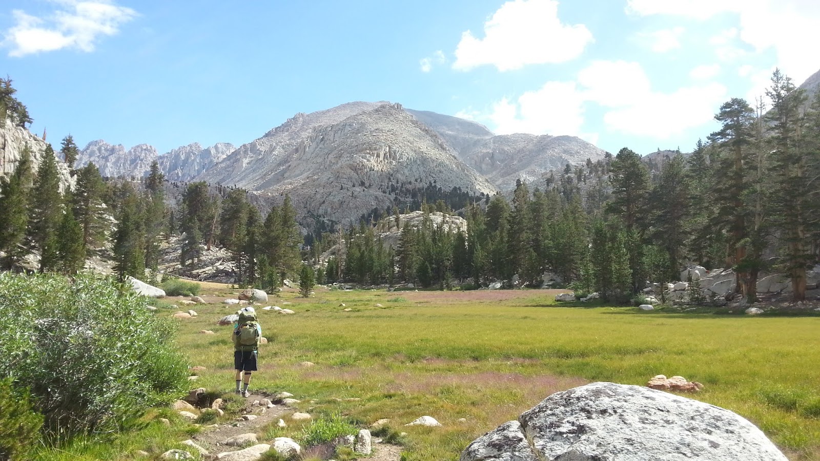
We were now in the midst of the dying. All around us the end of season and the imminence of winter was on full display. From the floor of the Owens Valley, you only catch a glimpse of the colors of death. But here, up canyon at 8,200', you're enveloped in the vibrant reds, warm oranges, brilliant yellows, and muted browns of the changing seasons. There's no escaping it. Here, you can literally smell the vegetation as it decays. Here, you can feel life slipping away. It's a full-body sensory experience.


For we humans, death and dying is generally an ugly, morose, and sad affair. We don't know how to do it with style. Not so the Aspen, Alder, Maple, Oak, Birch, Willow, and Cottonwood. They do not go gentle into the good night. They rage against the dying of the light as Dylan Thomas taught. Summoning all they have left, they go out in one final and exuberant explosion of glory and beauty. Oh to be like them. 

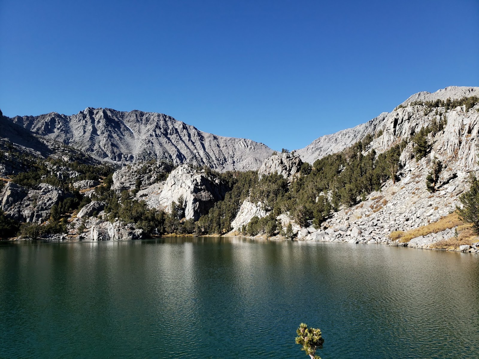
As we climbed into the drainage, the scenery gradually returned to the familiar stone gray and ever green of the Sierra. The path into the basin parallels the North Fork of Big Pine Creek that was still coursing strongly late into the season. At about the 10,000' contour, we crested a rocky prominence and were gobsmacked by the stunning emerald beauty of Lake 1. Further up-trail, Lake 2 did the same thing to us. We thought about stopping to just absorb what we were already seeing, but the drugs had taken hold. We were now Big Pine lake junkies in need of more. So we pushed on toward Lakes 4 and 5.

That decision proved worth the effort. Lake 5, set as it is against the backdrop of towering Two Eagle Peak, was an idyllic and scenic spot to have a snack and rejuvenate in the warm, late-season sunshine. Physically and spiritually fulfilled, we then retraced our steps back to the the golden trailhead as the shadows got long and the light began to dim. In the car again, we drove down canyon out of the blue and into the black as the final sputterings of day disappeared with the sun behind the darkened Sierra crest.

My, my, hey, hey.


Saturday, August 4, 2018

Chased Out of the Miter Basin

The Miter Basin
I’ve got a Tom Harrison map of the Whitney Zone that I unfurl now and then so that I can daydream about all of the nooks and crannies on that map that I still need to visit. One of the places I’ve stared at and imagined for a long time is the Miter Basin. Surrounded by an assemblage of white granite peaks, spires, and domes, and dotted with lakes with names like “Sky Blue” and “Iridescent,” I always found this trackless and relatively remote area irresistibly alluring. And I wanted to visit it.

So I finally conceived a plan and convinced my daughter and a friend from Utah to join me on a romp into the heart of the basin. The loose itinerary involved a loop of sorts beginning at the Cottonwood Pass trailhead. The plan was to spend the first night a lower Soldier Lake, a second night a Sky Blue Lake, and a third night in the Cottonwood Lakes Basin. We’d make the short walk out and back to the car on the morning of the fourth day.

So on a Wednesday afternoon we loaded up and headed for the Alabama Hills where we car-camped at Tuttle Creek. The next morning we were up early for coffee and permits. We didn’t actually have permits reserved, so we had to wait until the Eastern Sierra Interagency Visitor Center opened at 8 a.m. for the lottery. When we got there around 7:45 a.m. there was already a line of about 30 folks doing the same. I sauntered up to the entrance and was innocently milling about when a dude with his girlfriend barked at me for trying to cut the line. I told the guy that there was no line, and that we’d all draw numbers from a hat to determine our order. Shortly after that, a Ranger appeared with a bucket and made me look like a sage. We then all drew numbers. I pulled number 3; the guy that barked at me pulled something much worse. We got permits no problem. I don’t know about the other guy.

Car Camping in the Alabama Hills
Forty-five minutes later we were on the trail and making our way up to Cottonwood Pass. If you’re an old man living at sea level, one of the nice things about the trails departing from Horseshoe Meadow is that you’re already at elevation. You of course still end up climbing with a fully-loaded pack, but it’s a kinder, gentler climb that allows your body a bit of time to acclimate to both the weight of the pack and the less oxygen-nutrient air.

At Cottonwood Pass, we paused briefly for snacks and to snap pictures for a group that had spent a week or so making the circuit around the Big Whitney Meadow area. We then jumped onto the PCT and made our way to Chicken Spring Lake to tank up on water since it wasn’t evident whether we’d have another chance before we reached lower Soldier Lake.

Horseshoe Meadow
Cottonwood Pass

PCT
Chicken Spring Lake
From Chicken Spring Lake, the PCT climbs briefly out of a shallow cirque and then remains relatively level at about the 11,300’ contour until it crests a low rise and begins a slow descent into the vast Siberian Outpost. Here we stopped briefly to admire the stark landscape and the interplay of sun and shadows being cast by storm clouds to the west. A harbinger of things to come.

A mile or so beyond this is a well-marked trail junction. Going south will take you up over the Siberian Pass and into the Big Whitney Meadow area. Continuing west along the PCT leads to Rock Creek and beyond. We veered north on the pleasant connector which ultimately intersects with the path that leads east up over New Army Pass and northwest to lower Soldier Lake. Just before that intersection, the connector crosses a stream which was running strongly and could serve as a good source for replenishing water supplies. We were still good in that regard, so we pushed on to our destination.

The spur leading to lower Soldier Lake is dotted with campsites and a single bear box. There are additional sites immediately adjacent to the lake as well, but we didn’t know when we first arrived. As we inched along the spur, we were somewhat surprised to find that every single site was occupied. One large site housed a group of ten 20-somethings from Ohio State who told us they’d been on the trail for 26 days. The last site before the lake was taken by a sole older gentleman who offered to split the site with us. We gratefully accepted and shared our whiskey with him as recompense. Turns out our camp host was enjoying his first night of a solo hike of the JMT. The following day he was headed for Guitar Lake so that the day after he could summit Mt. Whitney and officially begin his through-hike.

PCT Views

Rock Field

Siberian Outpost
Connector to Lower Soldier Lake

Camp View at Lower Soldier Lake
The next morning we had planned to penetrate the Miter Basin. The intended route was the “short-cut” which follows a use trail that skirts the west side of lower Soldier Lake and then climbs the low rise on the north-west end of the lake. Upon seeing the route, my daughter expressed a bit of trepidation so we back-tracked to the main trail and tacked southwest to the mouth of the Rock Creek drainage.

There is supposed to be an obvious use trail leading up drainage, but it wasn’t obvious to us. We ran into a couple of young ladies looking to do the same thing we were doing and we all fumbled around a bit looking for the non-existent use trail. Finally, we forded Rock Creek and began ascending the west side on something that kinda, sorta resembled a faint use path or game trail. After bashing through brush for a bit and climbing obstacles, our female companions apparently called it quits because we didn’t see them again. Determined or obstinate, we continued forward for about ¼ mile when we burst into a wide, open meadow bisected by Rock Creek. One the east side of the creek, we finally saw the well-trod use trail we’d been searching for and jumped the creek to beat its path.

Meadow Near Rock Creek Junction

Rock Creek as it Flows Out of the Miter Basin

The Meadow - Use Trail to the Right
From here, the route forward was pretty simple: continue up the basin. We occasionally lost then relocated the use trail, but it’s pretty hard to get truly lost here as there is only one way in and one way out. Ok, that’s not entirely true, but practically speaking it is for most mortals, and that included us.

The scenery here is as sublime and glorious as I had imagined it. The Major General sits high on your right. Mt. Corcoran, Mt. LeConte, and the Shark Tooth, all 13,000’+ dominate the skyline to the northeast. The spikey Miter scrapes the sky to the north. And an unnamed granite spire and 12,000’ solid granite walls hem you in on the west. Our intended destination Sky Blue Lake, sits in a bowl above a series of cascades sandwiched between the Miter and Peak 13,221’.

But about ½ mile out, as we approached the final ascent to Sky Blue Lake, the sky after which the lake is named became ominous. The wind, which had been still throughout the day, began to howl. The temperature dropped. We started to hear the crack of lightning and the rumble of thunder. And then the heavens opened up and it began to rain. Then it hailed hard enough to coat the ground with tiny balls of ice. Then it rained again, harder this time.

We stopped to evaluate the situation and ponder the night ahead. My trail companions looked dubious. My daughter, the more level-headed of the two of us, was reluctant and urged retreat to lower ground. Dejected, I relented and we started to beat a retreat back to Soldier Lake.

On the way out, we bumped into a young lady that was part of the Ohio State contingent. She had gone into the basin on a day exploration and was retreating to Soldier Lake as well. When we discovered that she was returning via the “shortcut,” we stalked her all the way back to the lake which in fact shaved off a fair amount of distance and time.

Granite Cliffs Abound

Pushing Deeper Into the Basin

Typical Basin Views
Lower Soldier Lake from Atop the Shortcut
Back where we started the day, we set up camp lakeside on the peninsula of sorts that juts into the lake on its south side. As soon as our tents were up, the rain began and we took shelter. And then it rained, and it rained, and it rained. And it hailed again. And then it rained again. For three straight hours, the rain relentlessly pummeled our sad little fabric shelters which finally wetted out despite a valiant struggle to keep us dry. At dusk, the precipitation finally subsided and the clouds gradually began to move along and ruin someone else’s party.

The next morning was brisk and clear. We took our time breaking camp in order to allow our gear to dry some. Then we were back on the trail ascending the stunningly gorgeous valley that climbs to New Army Pass from the east. As the climb stiffened, and the suffering began in earnest, the beauty of my surroundings began to fade. Actually, the surroundings didn’t change at all. It was just my frame of mind. The Buckeyes were in front of us, and I tried to use them as my rabbit, but I couldn’t keep pace with the youngsters, including my daughter who blasted the ascent with no problems. Finally atop the 12,310’ pass, we stopped to refuel and to immerse ourselves in the moment. It was chilly and breezy at the pass and billowy clouds were starting to accumulate on the horizon.

The climbing for the trip complete, we descended the spare cirque that cradles appropriately-named High Lake. A fair number of hikers were struggling up as we came down, including a guy attempting to prod, poke, and cajole a group of adolescent boys up to the pass. We offered encouragement, but the boys just looked at us with utter contempt. I laughed because I knew how they felt. At Long Lake, we stopped again to pump water and solidify our plans for the evening. Charcoal gray thunderheads were now boiling up over the peaks to the northwest and the skies to the east and south were darkening. Remembering the onslaught we endured the night before, we determined to admit defeat and walk the rest of the way out. Midway back it began to rain again.

Back in Lone Pine, we figured we’d salvage the remainder of the trip by getting eats, beer, and firewood for another night of car-camping at Tuttle Creek. But even here, the weather refused to cooperate. While we were in town, the wind kicked up and the sky turned black. Lightning cackled and thunder thundered in the distance. We knew our fate was sealed. So we jumped in the car and made the long drive back to predictably and reliably dry civilization. 

Lower Soldier Lake Campsite

Climbing to New Army Pass

Approaching Near New Army Pass

Mt. Langley from the New Army Pass Trail
High Lake, Long Lake, and South Fork Lakes from New Army Pass

Descending the East Side of New Army Pass

Stunning Rock Formations
Long Lake

Cottonwood Lakes Basin


Thursday, September 1, 2016

Reelin' in the Years Along the High Sierra Trail


Your everlasting summer
You can see it fading fast
So you grab a piece of something
That you think is gonna last
But you wouldn't know a diamond
If you held it in your hand
The things you think are precious
I can't understand

A couple of years ago I really started feeling the urgency of time. I don’t know what brought it into focus—perhaps it was turning 50, or maybe the onset of certain old man ailments and conditions—but I suddenly came to understand that there was much I still wanted to do – no needed to do – but the window to accomplish that was narrowing with each 24-hour cycle. That epiphany about the finality of time, something of which I was subconsciously aware but which I had consciously ignored, caused a fair amount of a panic in me and the words of Roger Waters began to invade my thoughts and disrupt my equilibrium like never before:

Tired of lying in the sunshine staying home to watch the rain
You are young and life is long and there is time to kill today
And then one day you find ten years have got behind you
No one told you when to run, you missed the starting gun

So you run and you run to catch up with the sun but it’s sinking
Racing around to come up behind you again
The sun is the same in a relative way but you’re older
Shorter of breath and one day closer to death

So I began running. To catch up. Trying to tick things off my modest bucket list before the sun could overtake me from behind again. Foolish and futile.

What I wanted to accomplish as much as possible was to freeze the moment—see more of the people and the places that surround me now. I wanted to read books. I wanted to write stories. I wanted to take pictures. But most of all I wanted to ascend peaks and walk trails. I wanted to immerse myself in the Angeles National Forest, the Los Padres National Forest, and the Sierra Nevada before I no longer could. So I began covering the local terrain in earnest.

Most of my explorations were solo endeavors. My kids did join me on a handful of occasions, but mostly they stayed away. They’re young and had priorities other than wandering around the forest with their overly-opinionated father. And they had time that I felt I didn’t. That was me as a youngster too.

But then they started fledging from the nest to go make their own way in the world. First my eldest daughter to San Francisco. And in the space of few days before this was written, my son to the South. So the three of us talked about doing a trip together before they drifted away to become part of the family diaspora. We didn’t want to just go out for the day in the local mountains. Instead, we wanted to do something more monumental, meaningful, and memorable. I did a trip like that with my pops back in the mid-90s when both he and I were younger. A four-day float trip down the San Juan River through the broken desert of eastern Utah.  We floated the cool green waters of the San Juan during the hot day and slept on the sandy riverbank beneath the silent sky during the warm nights. It was time spent with my dad that stands out in memory more than almost anything else from the past. It was a lifetime event that I now wanted for my kids.

So the decision was made and permit secured. We would spend 5 days and 4 nights along the High Sierra Trail in Sequoia National Park. The justly famous trail begins at Crescent Meadow in the Giant Forest, tracks up the dramatic Middle Fork of the Kaweah River, crosses the Great Western Divide, and ultimately terminates atop Mt. Whitney some 60 miles east. But our aim was more modest: we would only go as far as the Hamilton Lakes.

Because you must pick up your wilderness permit the day before your entry date (or risk having them released to someone else), we made our way to the Lodgepole Village the afternoon before our trip was to start. Even though it was mid-week, Lodgepole was thronged with tourists who were as eager to experience Sequoia as we were. The crowds were so intense that it left my son bewildered and dismayed. It took some convincing to get him to accept the idea that where we were going, these folks would not follow. 

Permit in hand, we migrated to our assigned, yet underwhelming campsite—Lodgepole #4—dropped the car and gear, and then started up the Topokah Falls Trail in search of a water hole along the Marble Fork to the Kaweah. I had been along this stretch of easy trail years before and knew the swimming here was fine, but memory ultimately failed me and we never found the exact spot that I intended now to revisit. Instead, we walked the entire 1.7 mile length of trail to Topokah Falls which at this late stage of the season was just drizzling off the granite headwall. There we found a nice pool which we shared with some other folks who spoke a foreign language we didn’t understand. We swam in the dark water, drank a bottle of craft brew that we had carried up the trail for just this occasion, and then returned to our campsite to sit beside the campfire as the day turned into night.


Topokah Valley
Meadow Along the Topokah Falls Trail
Forest Views
The Watchtower from the Topokah Valley
Topokah Falls Trail
The Watchtower (8,983')
View Up the Topokah Valley 
Swimming Hole at the Base of Topokah Falls
Looking Back at the Watchtower
The Trail Back to Lodgepole
Over-the-Shoulders Glance at Topokah Falls
Big Tree Country
Looking for a Waterhole Along the Marble Fork of the Kaweah
Lodgepole Swimming Hole
Local Forest Denizen
Lodgepole Campsite #4 - Home for the Night :/
Early the next morning we hoisted 40 lb. packs onto our backs and began walking through the lush and mosquito-rich landscape that is Crescent Meadow. Within the first 15 minutes of our journey, we came face-to-face with a black bear, a big, dark, handsome boy foraging in the thick undergrowth. Although he was uncomfortably close by, he was remarkably unconcerned with us. And strangely enough, we him. So we admired him for just a bit, thrilled by the chance encounter, and then left him to his own devices. After all, bear sightings were getting kind of routine. We had already seen another bear roadside on our way into Crescent Meadow that morning and would see another one, much closer, on our way out.

Beyond Crescent Meadows and out of the Giant Forest, we were suddenly trekking high above the deep valley carved by the Middle Fork of the Kaweah. Here, intoxicating views of Moro Rock, the Castle Rocks, and the Great Western Divide prevail. Water from the Panther and Mehrten Creek drainages splashes across the trail. And wildflowers, long absent from the low country of Southern California, abound. We stopped frequently to drink in both the views and the abundant cold water. 

The trail from here to Buck Creek is very scenic and relatively flat. It snakes its way through a number of drainages and wends in and out of coniferous groves. But there is trouble with the trees. The forest is dying, a victim of the dual scourge of persistent drought and bark beetles. Large swaths of it, in some places up to 70%, are now rust, the telltale color of death. The rangers are justifiably worried. But they are powerless to do anything. So the die-off will continue. At least until the rains return. Or an inferno obliterates the desiccated tree-scape so as to permit a fresh start.

Bear #1 at Crescent Meadow
Obligatory Trailhead Photo
Amazingly lush Crescent Meadow
Early morning light streaming through the forest
Bear #2 at Crescent Meadow
Healthy looking boy
More bear #2
Leaving bear #2 to forage as we go on
Emerging from Crescent Meadows and the views begin to pop
Taking in the immensity of it all
Trailside Tiger Lily

Along the trail
Deer sighting
Beautiful greenery
Capturing the Great Western Divide

Looking back into the Middle Fork of the Kaweah River
Dramatic vistas ahead
Lots of water opportunities between Crescent Meadow and Bear Paw
Nine miles in, the trail dips into Buck Canyon before ascending to Bearpaw Meadow. Buck Creek, which carved this canyon from granite, ribbons through the rocky canyon bottom. We stopped here to cool off in crystal pools in which native trout happily swim. Or at least they did happily swim until some jackass smoking a cigarette illegally scooped a few up in a net and then offered them to us. We scowled and told him no.

Continuing on, the trail steepened and the warm afternoon air suddenly grew uncomfortably still. The water we took in at Buck Creek now drenched our shirts as we ascended to Bearpaw Meadow. I had read that the backpackers’ campground at Bearpaw was a bit disappointing because it was located in a sloping, viewless, dusty, and heavily timbered area. As it turned out, that description is fairly accurate. But we had been walking a long time. And we were tired. So we stopped and stayed.

The night at Bearpaw was long, dark, and spooky. The dense canopy prevented any moonlight from filtering down to the forest floor where our tents sat. And the surrounding trees were continually shedding bark and limbs onto the ground throughout the night. As a result, we were never quite sure if a snap of a twig or the crack of a branch was simply a nearby tree readying to fall upon us, or merely the mother bear and her cubs that we had been told had been frequenting the campground for the preceding week. At dawn we were up and out, happy to be leaving that place. 

Approaching Bearpaw Meadow

Forest canopy at Bearpaw
Backpacker's trail camp at Bearpaw Meadow
Campsite at Bearpaw Meadow
This day was mercifully short on mileage but long on the type of high country scenery that feeds the soul. Past the High Sierra Camp, the trail drops to a footbridge that crosses a deep gash carved by the upper stretches of the Middle Fork of the Kaweah, contours southeast to the Hamilton Creek drainage, and then steadily climbs through appropriately named Valhalla toward the Hamilton Lakes. Smooth granite domes, spires, and fins dominate the landscape hear. Looking at a map from the comfort of your couch, the Sierra appears as but a blip. But don’t be snookered by the map-makers. The enormity of this area is difficult to grasp. The scale is immense.   

The short climb was getting long and the mid-morning sun whose warmth we would have welcomed earlier was now starting to annoy. And then a miracle. Hamilton Creek washing across the granite trail at a spectacular vista point. Something about the universal attraction of water. Resistance was futile. So we stopped. We drank. We wallowed. Then we just loafed around in our drenched clothes listening to the hum of the place and absorbing its palpable energy.  

And we were not the only ones. Here we ran into a fellow doing the exact same thing we were doing. After he was done lying prone in Hamilton Creek, he told us he was going all the way through to Mt. Whitney. That was a common story we heard from other folks we met on the trail. And we met quite a few folks during the time we were out. We met sun-cured old men with white stubble on their chins, salt rime on their collars, and fire in their eyes. We met gregarious and pretty ladies accompanied by taciturn boyfriends who projected suspicion about any male who dared offer a kind word or glancing smile to their women. And we met solitary and bearded young men who lived entirely within themselves, preferring the comfort and ease of the trail to the awkward and potentially complicated camaraderie of others. Dirty, tired hungry, and thirsty folks all, but mostly friendly, happy, and sociable. Mountain people tend to be that way. And how could they not be? The mountains demand it. 

The youngsters
The old man

Canyon carved by the Middle Fork of the Kaweah River. The HST traverses the granite face to the right.
Nearing the bridge over the Lone Pine Creek gorge

Looking up toward the Hamilton Lakes basin
Hamilton Creek spilling across the trail. A welcome respite.
A fellow traveler cooling in Hamilton Creek
High altitude wildflowers at Hamilton Creek crossing

Lower Hamilton Lake
Dramatic Valhalla
Not far beyond where the trail crosses the creek, we crested a small rise and entered the basin holding picturesque upper Hamilton Lake. The day was unseasonably warm so we plunked down in the shade of a small evergreen poking out of the granite slabs, stripped to our skivvies, joyously jumped into the cool, blue waters, and then sat lakeside admiring our admirable surroundings.

Surprisingly (or perhaps not surprisingly), there were already a good number of backpackers at the lake set up for the night. In fact, most of what appeared to be “existing” camp spots were already taken. As a result, we were compelled the set our tents on a couple of bare spots separating the sheets of granite that form a patio of sorts on the lake’s northwestern edge. As we did, billowy, gray cumulous clouds began to build above the Great Western Divide. The dull thud of thunder boomed in the distance. And then the winds came. The unmistakable whoosh initially announced their arrival. Then we watched as they traversed the lake from east to west, transforming the water from still and cyan to frothy and white.

We and everyone else took shelter and waited for the downpour that never came. The winds, however, blew ferociously for almost an hour, filling our tents with fine Sierra grit. And then as suddenly as they began, the winds stopped, the air became still, and the lake placid. 


Upper Hamilton Lake

Another look at Upper Hamilton Lake from our front porch

The fruits of our labor: enjoying time and place
Camp at Upper Hamilton Lake
Later afternoon light

So you grab a piece of something that you think is gonna last...
Big granite
One of many camp visitors
Fellow campers
Bring on the night
As dusk approached, the deer began to arrive and troll through camp. Lots of them. Healthy and aggressive animals that were unintimidated by us and that would not be deterred in their search for a salty snack. Shirts, pants, sliders, bandanas, and hats were all on the menu. Another backpacker had told us about his encounter with one of these creatures at Precipice Lake the day before, and how it had stolen his trekking pole in order to use the handle as a salt lick. Appropriately warned, we hung our textiles as high as we could in the adjacent trees that night, but it wasn’t enough. The next morning, a fellow camper returned one of our bandanas that he had wrestled away earlier that morning from a marauding ruminant.

As the sun came up on the new day, the tents of the other backpackers with whom we had shared the lake came down and they all left.  Some went up the trail toward Precipice Lake and the Kaweah Gap, and some went down back toward Bearpaw Meadow, but away they all went leaving us as the only remaining campers. We quickly took advantage of the situation and relocated our tents to a premier, wind-protected site that occupied a flat bench above the lake. Then we swam in the lake, warmed ourselves in the radiant sun, swan again, and generally lollygagged for the remainder of the day.

That’s when it dawned on me. We had only been out on the trail for two days and two nights, but already my sense of time was significantly disrupted. I had become Crocodile Dundee: I didn’t know what day it was and I didn’t care. Time, or at least the measurement of time, was an artificial construct that had no real relevance on the trail. All that mattered was whether it was light or dark. Whether we were hungry or thirsty. And whether the dark clouds boiling up over the Great Western Divide were going to drop precipitation. Others we met experienced similar disorientation.  When we asked one group of hikers from New Hampshire how many days they had been on the trail, they just stared at us with confusion before looking to each other for assistance in remembering. We ultimately figured out that they had been on the trail nine days and eight nights.


Deer were plentiful and quite agressive
And not the least bit afraid
Handsome boy
Morning in the High Sierra
Valhalla served as a dramatic backdrop to our tent site

Early morning reflections off Upper Hamilton Lake
Light and Reflections
Alpenglow

Colors
Brother and sister
Mad and Maddie
The young man and the old man
The next morning we broke camp and started back with much lighter packs. None of us were enamored with the idea of another night at Bearpaw Meadow, so we set our sights on Buck Creek instead. We could have walked the entire way back to Crescent Meadow that day, but our ride wasn’t coming to meet us until the day following so breaking the return journey into pieces was a necessity.

At Buck Creek, we found the designated campsites buggy, claustrophobic, and unattractive. So we opted instead to spend the night in the open on the huge granite slabs that comprise the Buck Creek drainage. Others who came later in the day followed our lead and chose to camp with us on the rocks instead of in the brush. During the day, we hid in the shade beneath the footbridge over Buck Creek like trolls trying to stay cool and hydrated. At night, we laid on the smooth granite looking up at the cosmos in the ink black sky.

On our last day, we reluctantly walked out. Somewhere west of Mehrten Creek we came upon a ranger coming in the opposite direction. He said hello. I asked him to show me his wilderness permit. We both laughed. Then just before reaching Crescent Meadow, we rounded a bend and startled another bear. This one was big and cinnamon colored. The encounter happened so fast and the bear was so close that neither of us had much time to react. We instinctively yelled. The bear bolted a short distance then stopped and turned toward us. My son picked up rocks. My daughter reached for her bear spray. I told them to hold fire while I yelled again. The bruin moved toward a nearby tree preparing to climb it. That gave us wide enough berth to slip by him without incident and continue on our way.  

Back at Crescent Meadow my friend Chris was awaiting our arrival with Grapefruit Sculpin on ice. Crowds swarmed the meadow trying to get a small piece of what we just experienced. The folks from New Hampshire who we had met on the trail earlier came straggling into the parking lot. Chris snapped an obligatory picture of us next to the High Sierra Trail sign, we waved goodbye to our friends from the Granite State, and then we unenthusiastically loaded into the car for the long drive south down the I-5. 

Breaking camp
A couple more looks at Upper Hamilton Lake
Here comes the sun
Valhalla shadows
Re-crossing Hamilton Creek on the way back
Sierra Alligator Lizard Maybe

Big granite
Back in the forest
Campsite at Buck Creek

Back in Crescent Meadow
It is finished