 |
| Pointy Chief Peak as Seen from Chief Peak Fire Road |
Ok, calling it the "ugly way" is a bit of an over-statement. Maybe the "uninteresting way" would be a more apt description since the views along the way are pretty spectacular even if the hike up is rather, um, "pedestrian." Either way, fire roads are not my favorite way to get to a peak and this hike involved quite a bit of fire road.
So why go the fire road route if there are other alternatives? I'm glad you asked that. At 5,587 feet, Chief Peak is the highest point along the Nordhoff Ridge. I've been eying it for some time, but thought a summer route from the north would be preferable to climbing out of the Ojai Valley by way of the potentially scorching route up south-facing Horn Canyon. I was also looking for the most direct route to the summit of the Chief's somewhat out-of-the-way location. Looking at Tom Harrison's map of the Sespe, I didn't see any routes that fit those criteria other than fire road 5N42 out of Rose Valley campground. 5N42, which is the entry for ORV access to the Nordhoff Ridge, climbs south out of Rose Valley to intersect with Chief Peak Road. From that intersection, the route takes you east along the Nordhoff Ridge via Chief Peak Road until your reach a fire break approximately 1.5 miles later that affords easy access to Chief's summit. North-facing, short, and direct. So that was the route I settled on.
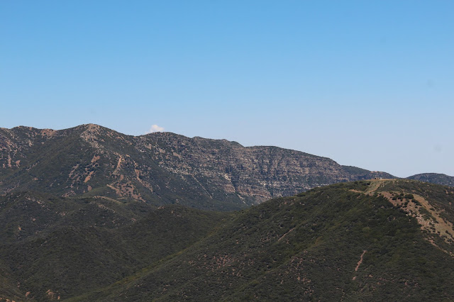
 |
| Thorn Point and the Sespe from Fire Road 5N42 |
 |
| Upper Rose Valley Falls, Such as They are at the Present |
 |
| Pine Mountain Ridge from Fire Road 5N42 |
 |
Pine Mountain Ridge Detail
5N42 begins at the rear south-west corner of the Rose Valley campground. There is a small spot to park between two campsites near the trailhead for Rose Valley Falls that you can squeeze into. Adventure Pass required I believe. Almost immediately, the road begins a relentless climb toward the Nordhoff Ridge to the south. Candidly, I was surprised by the sustained steepness of the road, although it is well smooth as a baby's bottom and well maintained. The day was warm and the bugs were out in force which was annoying, but as the road climbed out of Rose Valley, the dramatic views really begin to open up and a breeze kicked up for which I was eternally grateful. To the south-east, the Rose Valley Falls are visible. To the north lies the Piedra Blanca, the Sespe, and the ramparts of Pine Mountain. Looking west, you catch of glimpse of the Howard Creek trail as it makes its way toward Nordhoff Ridge several miles away.
|
 |
| 5N42 Flora |
 |
| The Howard Creek Trail Climbing to Nordhoff Ridge to the West of 5N42 |
 |
The Nordhoff Peak Fire Lookout Standing Sentinel in the Distance
After approximately 2.2 miles of climbing, 5N42 intersects the Nordhoff Ridge. From here, and all along the ridgeline, you are treated to expansive views south of the Ojai Valley, the Oxnard Plain, and the Channel Islands in the Santa Barbara Channel. The road going east from here will take you out to Chief Peak and beyond; the road going west roller-coasters along the ridgeline out to Nordhoff Peak.
|
 |
| The Ojai Valley and Beyond from Chief Peak Road |
 |
| The Oxnard Plain and Pt. Mugu from Chief Peak Road |
 |
| The View North Toward Thorn Point from Chief Peak Road |
 |
| Piedra Blanca and Thorn Point |
 |
The Upper Ojai Valley from Chief Peak Road
Atop the Nordhoff Ridge, the traveling is easy. Basically a stroll along an undulating fire road. A jeep passed me as I ambled along the road absorbing the scenery and solitude, but I had no other company except the halo of flies that magically appeared when the breeze was suddenly stilled. Approximately 1.5 miles later, an obvious fire break to the right signaled it was time to leave the road for a bit of welcome cross-country travel.
|
 |
| Approaching the Chief from the Nordhoff Ridge |
 |
| Thorn Point Framed by a Nice Meadow |
 |
The Firebreak Leading to Chief Peak. You Leave the Road Here
The firebreak requires a scamper up a steep, loose slope to the top of the "bump" to the Chief's immediate west. From the vantage point atop the bump, you get a good look at the Chief up close and personal and the rocky route ahead. That route follows a use trail to the base of the rocky out-cropping shown in the picture below and then contouring around to the south side for some Class 2 scrambling to the top.
|
 |
| Close Up of the Chief. The Route Up Contours Around to the Right in this Pic |
 |
| The Ojai Valley and Channel Island from Chief's Summit |
 |
Anacapa Island Peaking Out from Above the Coastal Fog
Atop the summit I found two benchmarks, a summit register, and rocky aerie upon which to lunch and appreciate the 360 degree vistas. Even though the fog clung heavy to the coastline, the Oxnard Plain, Pt. Mugu, and the Santa Monica Mountains were all plainly visible. Although partially obscured from view, Anacapa Island also poked its head through the cloud cover to make its presence known. Looking north brought views of Reyes and Haddock Peaks, the upper Sespe drainage, Piedra Blanca, and Thorn Point. The Topa Topa Bluffs featured prominently in the view to the east.
|
 |
| The Sespe from Chief Peak Summit |
 |
| The Topa Topa Bluffs |
 |
| One of Two Benchmarks Atop Chief Peak |
 |
| The Second Benchmark. This One Looks More Recent. |
 |
| Chief Peak Summit Register Adorned with Eispiraten Logo |
After spending what was far too short a time on the summit, I scrambled back down to Chief Peak Road and began my way back to Rose Valley. On the ridgeline, the breeze kept things tolerably pleasant and the bugs at bay. Descending 5N42 on the backside of the ridge, however, the breeze abated and the bugs became my constant companion all the way back to Rose Valley campground.
So that's my story and I'm sticking to it. Although fire roads are generally not my preferred mode of back-country travel, in this case the ease of access, the direct route they provided, and the amazing scenery all made up for the "ugliness" of not having a trail to tread.


