Sunday, October 31, 2021

Wright Mountain Hootenanny and Grilled-Cheese Extravaganza


Gobblers Knob Summit

I'm into grilled cheese. Grilled cheese makes me feel beautiful.
~Emma Stone

The poets have been mysteriously silent on the subject of cheese.
~Gilbert K. Chesterson

Men only need two things: grilled cheese and sex.
~Emmy Rossum

Ruminations on Grilled Cheese

The grilled-cheese sandwich. Two slices of white bread, butter, and cheese. A gastronomic staple of childhood and the culinary stuff of adulthood nostalgia. I never really thought that much about how enjoyable the combination of hot cheese and toast could be. And I certainly never considered the absolute epicurean genius one must possess to imagine, and the actually grill, grilled-cheese sandwiches on a mountain top. But a recent group outing to Wright Mountain in the San Gabriel Mountains brought me cheesy enlightenment about these important subjects. 

The event that set the table for this sudden understanding was the 14th anniversary of the San Gabriel Mountains Discussion forum. The forum is a San Gabriel Mountains-focused on-line board for posting trip reports, photos, information, questions, nonsense, and other valuable (and invaluable) whatnot. To celebrate the forum's 14 circle around the sun, Sean (aka Cucamonga Man), one of the board mucky-mucks, planned a ramble to the summit of Wright Mountain from the east starting from PCT mile marker 356 at the end of Forest Road 3N31. The plan was to arrive Saturday afternoon, car-camp at road's end beneath Gobblers Knob, and then hike westward along the Pacific Crest Trail ("PCT") to the summit of Wright Mountain.

Meet Up Beneath Gobblers Knob

After a slow and bumpy ride up 3N31 from Lone Pine Canyon, I arrived at the designated spot late Saturday afternoon. It was the middle of deer hunting season in Zone D11, so I passed several armed hunters in full camo on my way in. David and Elwood were already there when I arrived so I settled in with them as a heavy blanket of clouds began to broil up the ridge from the valley below. It was an ethereal scene reminiscent of the Ten Commandments when the Lord sent the breath of pestilence to kill the first born of the Egyptians. Fortunately, none of us perished as the fog passed-over while we drank beer and waited for Cucamonga Man, our Moses, to arrive so he could lead us to the promised land on the morrow. Much later, as the fog retreated and darkness replaced it, Dima and Sondra arrived to join the group. 

We were still above the cloud bank the following morning as the sun began to rise in the crystalline blue sky.  In an over-used word, it was spectacular. While we waited for Cecelia and JeffH to arrive to round out the group, I made a quick dash to the summit of Gobblers Knob. There is no trail to the summit, so I just gutted it out up a steep and loose old firebreak the follows the eastern ridge. The top of Gobblers Knob is wide and flat so it wasn't immediately apparent where the actual high-point was. But on the far western side of the summit I found a rock-pile which, officially or not, marks the spot. I could locate neither a register nor benchmark on Gobblers Knob, but I did find one of those ubiquitous triangular signs known as "witness posts." And it was the only time the entire trip that the back-side of Mt. Baldy would be visible.


North Fork Lytle Canyon
North Fork Lytle Creek Canyon

Lone Pine Canyon
Lone Pine Canyon

PCT Sunset
Sunset Over the PCT

Moon Over Lone Pine Canyon
Night Vision

Sunrise over Lone Pine Canyon
Sunrise Over Lone Pine Canyon

Gobblers Knob Summit
Views from Gobblers Knob

Gobblers Knob Summit
View West from Gobblers Knob - L to R: Baldy, Dawson, and Pine

PCT West to Wright Mountain

Shortly after I descended from the Knob, Cecelia and JeffH arrived and we headed out, jumping onto the PCT which transects the parking area. The well-maintained trail skirts Gobblers Knob to the north as it climbs gently toward the Blue Ridge and Wright Mountain. As you go along, the transition from a more scrub-dominated environment to a lush evergreen plant community is obvious and striking. You also get good looks at Dawson and Pine which dominate the southern skyline. Ultimately, the trail tops out and joins an old fire road that wraps around the south side of Wright Mountain. Here, we stopped at a window above the slide area at the head of Heath Canyon for snacks and the sublime scenery. Wrightwood and the high desert were visible in the foreground, while the southern Panamints could be seen on the northern horizon.

The final push had us ascending a faint, old road bed of some sort to the summit of Wright. Like Gobblers Knob, the forested crown of Wright is broad and flat and the actual high-point is not immediately obvious or intuitive. To complicate matters further, a series of use trails criss-crosses the summit plateau in a sign that a good many others have also spent time and energy wandering around in search of the actual "top" of Wright. But Cucamonga Man knew the way and led us to a rock-pile on the north end that apparently qualifies as the official summit. 

Grilled Cheese Sammies on the Summit

As we settled in to luxuriate in our achievement with our bland old trail mix, beef jerky, and granola bars, chef de cuisine JeffH dug into his stash of secret goodies and pulled out all the makings for grilled-cheese sandwiches. In a flash of mad-scientist brilliance, he had packed a loaf of bread, slices of American cheese, a container of butter, a frying pan, a spatula, and his stove. He then went about grilling sammies one at a time for everyone. It was candidly delicious and we all sat around in the warm sun extolling the awesomeness of Jeff's gastronomical creativity and licking butter and melted cheese off our grimy fingers. 

Afterwards, we hoisted our packs back onto our backs and started the 4.5 miles back to where we started. On the way out, a few of our party climbed Gobblers Knob via its north ridge. That route looked much more accessible than the east ridge that I climbed previously, and I then wished I had waited to ascend the Knob using that approach. Back at the parking area, we cracked cold beers as Cecelia broke out chips, salsa, and guacamole. Another stroke of inspiration. That probably sounds a bit over-stated, but I rarely bring post-hike food and drink to enjoy (mostly because I'm generally solo), so this was a really tasty treat. 
On the way out, I took the long way down 3N31 out of Lytle Creek just because. Although considerably longer, the road out this way was an easier drive than the access from Lone Pine Canyon.

All in all, a fun day in a really nice part of the San Gabriel range.  

Pacific Crest Trail
Along the PCT

Pacific Crest Trail
Nearing Wright Mountain

Dawson Peak and Pine Mountain
Dawson Peak (L) and Pine Mountain (R)

High Desert from PCT
To Infinity and Beyond

Wright Mountain Summit
Wright Mountain Summit Cairn

Grilled Cheese Sammies on Wright Mountain
The Mad Scientist at Work

Memorial on Wright Mountain
Wright Mountain Beautiful Child
 
PCT Views
Views East to San Gorgonio and San Jacinto

Friday, October 8, 2021

Takin' 'er Easy at Polly Dome Lake

Polly Dome Lake

Lighten up while you still can
Don't even try to understand
Just find a place to make your stand
And take it easy.
~Take it Easy (Eagles)

The Dude abides.
I don't know about you, but I take comfort in that,
knowin' he's out there. The Dude.
Takin' 'er easy for all us sinners.
 ~The Stranger (The Big Lebowski)

Foiled by Fire - Tahoe Rim and Jennie Lakes


Several months back, when the hills were still rich with vegetation and the reverberating echoes of Spring deceived me into believing that fire season in California wasn't really a thing, I dreamed of taking a late-season, multi-day backpacking trip with my kids and some old friends. California's backcountry is immense, so the possibilities then seemed limitless. Thus, along with my backpacking co-conspirators, we began pouring over topographic maps, researching trail descriptions, and plotting potential routes through the forests and ranges that comprise the vast Sierra Nevada. Ultimately, we settled on a section of the Tahoe Rim Trail, a 165 mile path that circumnavigates the famous sapphire pool that straddles the California-Nevada border. That selection seemed to have everything that an outdoor enthusiast could possibly desire: scenery, easy access, scenery, adequate water, and scenery. Plus, it was proximate to post-adventure beer and tacos. That was the real clincher.  

And then in mid-August, as the date for our departure began to creep over the horizon, the Caldor Fire ignited and the El Dorado Forest near Lake Tahoe began to burn. As the conflagration raged out of control and evacuation orders forced locals to flee to wetter ground, smoke darkened the skies and ash rained down over the Tahoe Basin. The best laid plans...

So we scouted alternatives and settled on the Jennie Lakes Wilderness near Sequoia-Kings Canyon ("SEKI"). It hit all the same marks as the Tahoe Rim Trail save nearby tacos and beer. We decided we could adjust to that minor imperfection and major inconvenience. 

And then it happened again. The KNP Complex fire ignited and suddenly SEKI was ablaze too. The fire began in the south, but steadily marched northward threatening the world's largest tree by volume and closing the park. Foiled yet again, we scrambled for a back-up to our back-up and miraculously found enough available permits for the Murphy Creek Trail in Yosemite. If the Tuolumne Basin started to burn, we were done. We'd just stay home and pout.  

But Yosemite didn't burn. So on a Thursday afternoon, we all converged on the trailhead along Tioga Pass Road, strapped on our packs that were heavy with whiskey and other goodies that would make the ultra-light set squeamish, and headed into the wilderness. 

Murphy Creek Trail to Polly Dome Lake


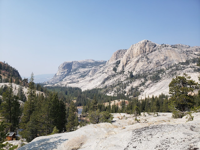
The Murphy Creek Trail is a short, flat, and pleasant walk through a lush coniferous forest that is occasionally interrupted by brilliant granite slabs that have polished smooth by the ancient glaciers that created this place. Classic Yosemite. About 2 miles in, a use trail branches to the right that takes you to the western edge of pretty Polly Dome Lake.  

The original plan, conceived when we were feeling ambitious about our adventure, was to hike to Polly Dome Lake for the first night, down to Glen Aulin along the Tuolumne River the second night, back to May Lake the third night, then out the morning of the fourth day. But after we arrived at Polly Dome Lake and set up camp, we decided to embrace our inner Dude and just take 'er easy. We'd use Polly Dome as our base the whole time and just day-hike to our planned destinations. That way, we could avoid the unnecessary hassle of repeatedly putting up and tearing down camp.  

Murphy Creek Trail

Polly Dome Lake

Polly Dome Lake

Polly Dome Lake Campsite

Day Hike to the High Sierra Camp at Glen Aulin


The following morning we brewed coffee in the cool mountain air. Inexplicably, the exact same coffee that you drink at home every single day suddenly becomes a gourmet experience when consumed from a titanium mug under a canopy of regal evergreens. If only I could say the same thing about food (Top Ramen excepted) which I find to be largely unappetizing at elevation. 

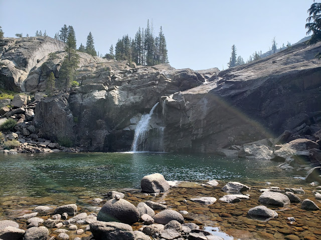
Anyway, sufficiently juiced up on caffeine, we then headed to Glen Aulin for the day which was a little less than 5 miles to our northeast. It was a slow descent on a beautiful, well maintained trail that permitted occasional looks at various peaks that stud the Tioga Pass area. At McGee Lake, a finger-like lake along the trail, we stopped for a brief spell to try our hands at swimming and fishing. Neither endeavor was particularly successful. We then made the final drop to Glen Aulin where the Tuolumne River comes spilling of the cliffside into a large, emerald pool. There's a High Sierra camp at Glen Aulin with bathrooms, water, and bear boxes, but all of it was locked tight and the camp was empty of campers. 

Ultimately, the nearby water proved too enticing, so we all gleefully stripped off our clothes and jumped into the waiting pool. A day-hiker nearby watched in bemusement. Almost immediately, we regretted our impulsiveness as the water was surprisingly frigid and major shrinkage ensued for all those with appendages that could shrink. We then sat like lizards in the sun, warming our now cold blood.  

On the way back to camp later that afternoon as my mind had wandered off as I wandered along, my friend suddenly exclaimed "bear!" I immediately snapped to attention, and sure enough, about 30 yards up-trail blocking our way was a very large black bear. When we checked in to obtain our permits, the ranger told us that bears were very active in the park and to expect a visit to camp every night, but that never happened. This was the only bruin we would see. As the bear ambled down trail toward us, we all started yelling and clapping our hands like fools to no avail. The bear was completely unfazed by our antics and continued slowly toward us. As we started to search the ground for projectiles, the bear moved off trail and we slid by without incident making it back to camp with a tale to tell.

Early Morning at Polly Dome Lake

Yosemite National Park

McGee Lake, Yosemite National Park

Glen Aulin

Grand Canyon of the Tuolumne

May Lake, the Geographic Center of Yosemite


The following day, we made the 4-mile trek to May Lake, the "geographic center" of the park. May Lake is a gorgeous high-country lake that sits in a basin beneath stark and towering Mt. Hoffmann. We briefly contemplated making an attempt at Hoffmann's summit, but consistent with our adopted Dude-aesthetic, we decided to simply sit shoreside and admire it from afar. 

There's also a High Sierra camp at May Lake replete with bathrooms, water, and bear boxes. Like Glen Aulin, the bathrooms and water here were non-functional. Unlike Glen Aulin, the bear boxes here were unlocked and stuffed to the gills. Loafs of bread, bottles of ketchup and mustard, and edibles of all types were crowded in, on, and under every box. And the camping area was congested with campers. It was a bit of a shit show even though it was late season. I suppose that is understandable given that May Lake is easily accessible from Tioga Pass Road via a mile and one-half trail. But as scenic and worthwhile as it was to visit for the day, we were quite happy to return to lonely Polly Dome for the night.

May Lake Trail

Mt. Hoffmann Yosemite National Park

May Lake Yosemite National Park

Yosemite National Park

Leaving Yosemite - the Last Day


On the final morning, we walked out, retracing our steps from day one. As always seems the case when you've been out a few days, we were both ready and reluctant to go. So we got moving early, but moved slowly, savoring the last moments of high-country bliss. Back at the trailhead, we unloaded our packs and retrieved the cans of malt and grain beverages that were stowed in the nearby bear boxes. We were going to just leave those in the trunk, but the ranger told us that bears can smell sealed beer through an aluminum can. Although we skeptically viewed that tidbit of information as nothing more than ranger scare-mongering, and despite the threat of theft by fellow hikers and hooligans, we ultimately were obedient little soldiers and stashed our stash in the bear boxes. And the beer survived the ordeal.

On the way down 395, we were hankering for some real food. After a couple of days of trial mix and tuna pouches and trail mix, we could think of nothing but burgers and fries and burgers, so stopped in Mammoth Lakes at the brewery to quell our hunger pangs and slake our thirst with a frosty mug. It was all very Dude and the perfect compliment to a good couple of days in the mountains.

Murphy Creek Trail

Murphy Creek Trail