Monday, January 9, 2023

The Agony of Defeat


Arlington Peak

Soy un perdedor
I’m a loser baby, so why don’t you kill me?
(Double-barrel buckshot)
Soy un perdedor
I’m a loser baby, so why don’t you kill me?
~Loser, Beck

In the foothills overlooking what is sometime hyped as the American Riviera, there’s a pyramidal-shaped sandstone peak that dares you to climb it. Back in the olden days, the locals apparently referred this peak as Cathedral Peak and its loftier neighbor to the northwest Cathedral Rock. Then, the U.S. Board of Geological Names rechristened Cathedral Peak as Arlington Peak and Cathedral Rock became the new Cathedral Peak. The “Arlington” nomenclature purportedly originated from staff at the luxurious Arlington Hotel who called the various peaks in the vicinity the Arlington Crags

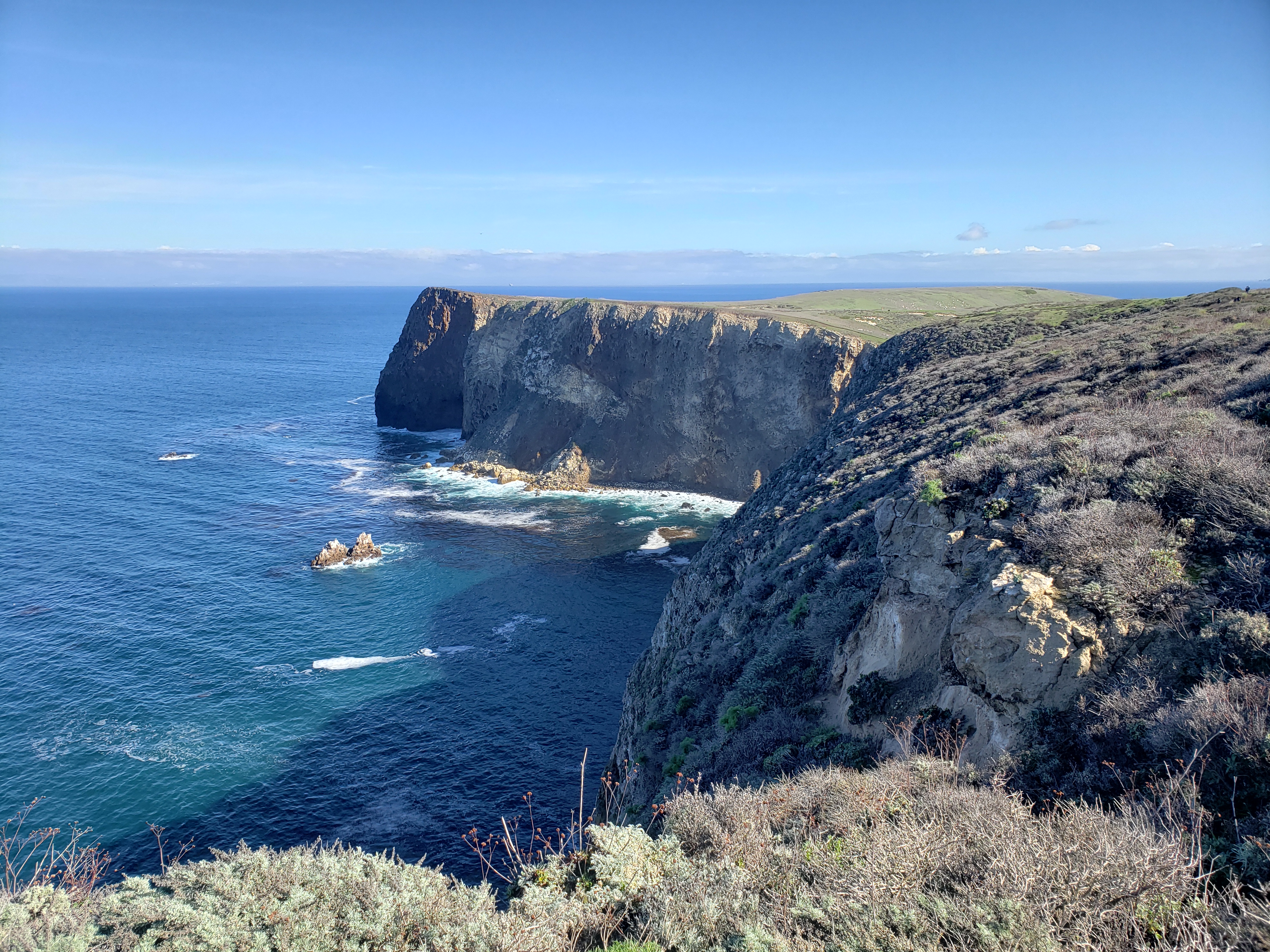
A few years ago, I took up the gauntlet that Arlington had dismissively hurled at my feet and made an attempt at its summit. I failed. I took the standard route up the southeast ridge by way of Mission Canyon, veering right on a faint use path immediately after crossing the creek and then clawing my way up to gain the ridge. Once there, I followed the route along the ridgeline as it wound its way around, over, under, and through the blocky sandstone for which Arlington is known. It was a warm winter day and I eventually bonked somewhere around the 2,500’ contour. Frustrated and tired, I sat on a gigantic boulder and salved my wounded ego with a warm beer. The magnificent views to Santa Barbara and the Channel Islands ended up being my participation trophy (which, in the grand scheme of things, really isn’t a bad participation trophy). 

That failed attempt has been an itch in need of scratching ever since. That itchiness flared up again this past weekend as I was thinking about options for getting out into the hills before the next round of drenching started. The weather was perfect for another attempt, so I decided that I’d drive to Santa Barbara to take care of some unfinished mountaineering business. 

Although I arrived late morning, cars were lining the street for almost a mile from the trailhead proper. I continued driving in hopes of scoring a spot closer up to avoid adding dreary road mileage to my day. I must have been living right that morning because as I approached road’s end without promise, someone pulled out leaving a spot for me right in the front row. I quickly took advantage, pulled on my boots, and started up the Tunnel Trail which initially is a deteriorating asphalt road. As I began to climb, I was astonished at the number of people I encountered both coming out and on their way in. Flowing water from the recent rains was bound to be big draw, but the Covid/Instagram-fueled assault on the outdoors continues unabated. 

A short distance up the road, the path splits and the asphalt turns to dirt. The right fork follows the Tunnel Trail to the Mission Crags and the Rock Garden; the left fork parallels Mission Creek to the junction with the trail leading to Inspiration Point. I followed the left branch into the canyon where I rock-hopped the creek which held a nice flow. On the adjacent side of the creek, I tacked hard right following an informal, yet well-beaten use path that climbs to Arlington’s southeast ridge. 

Arlington Peak's Southeast Ridge

Mission Creek

This is where the work really starts. The climb to the ridge is steep and physically demanding. It has also become deeply eroded and braided as a consequence of intense use. The various route options seemingly all get you to the same spot on the ridge, but as you’re ascending, you can never be quite certain that you’re on the “right” braid. To assist with navigation, someone has painted a series of white dots on the sandstone that is common here. Sometimes you see them, sometimes you lose them. Those damned dots are both a blessing and a curse.   

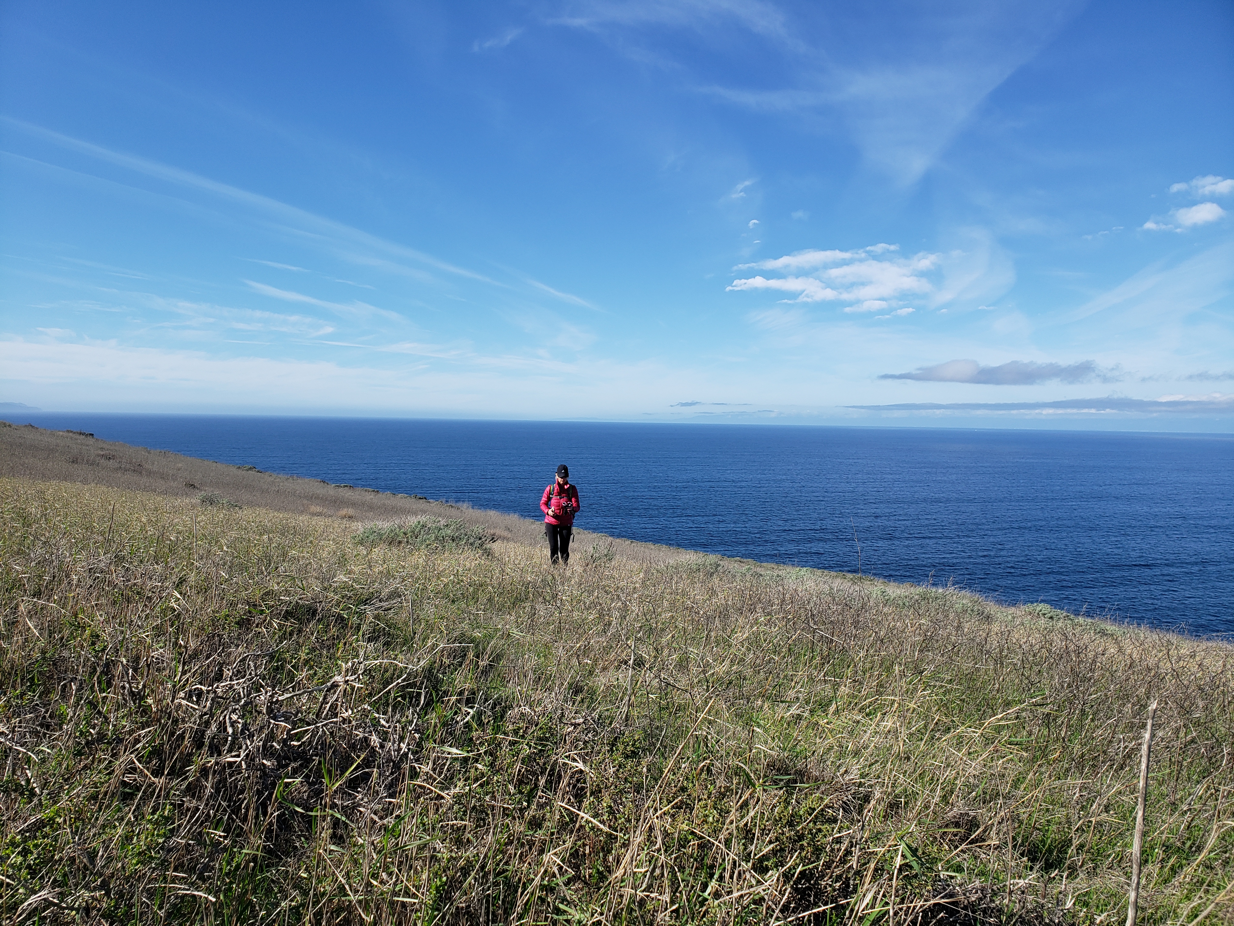
On the ridge, things level off for a bit and the views to the coast really open up nicely. Here you get to do a fair amount of scrambling over sandstone features as the path switches back and forth between the north and south side of the ridge. It’s a fun and entertaining alternative to ordinary hiking, but I wished that I had brought a pair of gloves along. The sandstone is unsurprisingly like, well sandpaper, and by the end of the day my hands were raw from the constant contact. 

I was making decent progress for an old guy until right around the 2,800’ level where the pitch steepens before the final summit push. As the route switched over again to the south side, there was a white dot painted on a rock just above a white arrow pointing to the left. From the looks of things, folks had been going left at this spot so I followed suit. Not long after that, I found myself at the base of a rocky wall in a steep chute with no white dots. The only way forward was up the rock face which was probably 20 feet high with a couple of class 3 moves. I felt fairly confident about my ability to scamper up, but getting back down was another matter altogether. Being solo, I didn’t think it wise to give it a go, so I back-tracked to the arrow to see if I had missed something. There I saw the last white dot but no real alternative to the route I had already followed.

Frustrated once again, but recognizing that discretion is the better part of summiting, I decided to turn back. If the price for achieving Arlington was notoriety for being the dumb ass that had to be rescued, I wanted no part of that. I’ve made enough poor decision in my life. I don’t need to compound that at this stage. 

Mission Canyon Falls


Santa Barbara

On the way down, my dogs were barking so I stopped for a snack and a cold malt and grain beverage I had stowed in my pack for just such an emergency. As I sat on a rocky outcrop enjoying the panoramic sight of the Santa Barbara coastline, I almost forgot what a loser I was. But I was quickly reminded of that as soon as I started moving again when I missed a white dot and ended up sliding down a steep, overgrown drainage. After descending that drainage further than was really advisable, and realizing the potential peril of continuing, I crab-crawled back up to the ridge where I relocated the track marked by multiple and obvious white dots that mocked my embarrassing lack of awareness. 

On the ride home, I assessed the situation. I’ve attempted Arlington two times now and both times I’ve failed. I don’t need to experience strike three to know when I’ve been vanquished. Some things are just not meant to be. And for under-achievers like me, summiting Arlington by the southeast ridge is apparently just one of those things. If I ever get there, it’s going to have to be top down by way of La Cumbre Peak.  

I know, I know. Soy un perdedor. I’m a loser baby, so why don’t you kill me?

Thursday, January 5, 2023

Scorpions and Potatoes - East Santa Cruz Island


The Captain announced that the seas would be choppy that day as we crossed the channel from the mainland to Santa Cruz Island, a place 25 miles off the coast that the native Chumash called Limuw. If you were prone to sea-sickness, the crew advised that the rear deck of the boat was the most stable place to be. Locking yourself in the only bathroom on board was not only ineffective, but it would make things worse as there was no sight-line to the horizon. Plus it was rude to your fellow passengers. Don’t do it. Barf bags would be provided to anyone who found themselves in significant gastric distress. 

Out of the harbor just past the breakwater, the northwest swells hit and passengers squealed as the boat chugged to the crest of one swell and then dropped into the trough of the next. Those standing starboard or on the bow were forced to retreat into the cabin to avoid being subjected to continuous spritzing while those on the upper deck maintained watch for dolphins and migrating cetaceans. As the seaworthy vessel tossed and rolled in the turbulent ocean currents, I thought of the grit and courage of the Chumash who once rowed across these same cold waters in tomols hewed by hand from redwood and pine.  

For about an hour or so we plied the continuous surge until the pier at Scorpion anchorage came into view. Here, the sea faded from a deep midnight blue to a translucent turquois dotted by the dark green kelp forests that proliferate in these protected waters. It was a kaleidoscopic orgy for the eyes. I was feeling a bit oogy from the trip as the engines died and we moored against the newly-renovated pier, so appreciated getting my landlubber’s feet back onto terra firma. 


It isn’t quite clear how or why the anchorage and the historic ranch here were named “Scorpion.” The National Park Service speculates that the designation could refer to either the shape of the valley or the fact that small scorpions are present. Either way, the name certainly isn’t native. Long before Juan Rodriguez Cabrillo arrived in 1542, the Chumash called this place Swaxil. It was the largest of 10 Chumash villages scattered around the island that was home to approximately 1,200 native people. Xaxas (pronounced “hä’ häs”), located at what is now known as Prisoners Harbor, was the second largest village on the island. In total, there are an estimated 3,000 prehistoric native sites on the island ranging from small ephemeral camps to formal villages. But that is all that remains of the original inhabitants. The last of the Chumash islanders were either killed by disease or forced from their ancestral lands by European colonization.

A trip to this island used to be a family tradition. When the kids were young, we’d make the journey with them every New Year’s Day while the rest of the world slept off its hangover. Now visits are more sporadic although there really is no objectively good reason for that. Maybe it’s because from the coast, the islands only exist in a distant, dream-like haze. You can see them sitting on the horizon, but you never quite know whether they’re real or just apparitions. So they end up as nothing but familiar backdrop to the vast blue oceanscape, easy to look past when you’re immersed in everyday living. 

Off the boat and on the pier, we were all corralled by a Park Service docent for a mandatory briefing. One lady tried to sneak by without stopping to receive instructions, but the ever-vigilant docent barked her back into place. Most of what we were forced to listen to was common sense stuff that we’d heard multiple times previously. Don’t trample the native vegetation. Stay on the established trails. It’s a federal crime to take anything from or disturb midden sites. There’s potable water on the island, but not food. Carry out your trash. You’d think folks wouldn’t need to be told any of this, but there’s always that one guy who was either raised by animals or who just doesn’t give a shit. So the obvious needs to be repeated out loud to everyone just to make sure that this one dumb asshole hears it even though he still won’t abide.

When the lecture was finished, everyone scattered like fifth graders freed from school for the summer. We got out in front of the mad rush and started up the easy service road leading to Cavern Point. We typically go the other direction toward Montañon Ridge and Smuggler’s Cove, but opted for the north-side views this trip. About half-mile up the road, near the intersection with the North Bluff Trail, things started to get sloppy due to the recent rains. We looked at the path leading to Cavern Point, but declined the invitation. The footpath leading to the point was a muddy, mucky mess. 

Instead, we headed west along with North Bluff Trail, a relatively level path that parallels the escarpment for a couple of miles out to Potato Harbor. It was a blue bird day and the views north and west were satisfying. If you’re a plant nerd, the flora on the bluff was also quite interesting. We noticed Giant Coreopsis (aka Truffula Trees) on the cliff edges that had emerged from summer dormancy to show off its finest spring greenery. We also saw plump Live-Forevers (Dudleya), Lemonade Berry, and a few other native and non-natives that all looked quite robust and healthy. We kept eyes out for the endemic Island Jay and Island Fox, but got skunked. 


The closer we got to Potato Harbor, the sloppier the path (now a road) became. To avoid the slippery mud, folks were walking the edges and trampling the vegetation. This is how paths widen and erode. We refused to play that game and defiantly trudged along right in the middle of the road, allowing the gooey, sticky mud to accumulate on the soles of our shoes like heavy pancakes. Unsurprisingly, no one else followed our lead. If they understood the point we were trying to make, they didn’t’ care. Principle must always take a back seat to clean shoes, especially when hiking.  

A good deal of mud later, we arrived at the overlook for Potato Harbor, so named for its tuber-like shape. Over the cliffs here, you look right down into the aquamarine waters of the isolated harbor. You can also see a good portion of the western side of the island which is owned by the Nature Conservancy and thus off-limits to us commoners. Given the destructive and exploitative history of the place, that’s probably not a bad thing ultimately.

There are several bare patches of diatomaceous soil near the overlook. Diatomaceous earth is bright-white, chalky, sedimentary rock derived from single cell organisms made of silica called diatoms. When dissolved in water and recrystallized, diatomaceous earth forms a hard glass-like substance called chert. The native Chumash mined chert to make arrowheads, drill bits, and scraping tools. They also used it to bore holes in Olivella snail shells to create beads for trade. The abundance of chert on eastern Santa Cruz Island explains the several sites that archeologists have described as Chumash “bead factories.”

We grabbed a seat in the cherty dirt and had a snack while listening to the ocean raging against the island’s north shore. Several other folks were doing the same. When we were finished, we started back to Scorpion anchorage along the same route we used coming out, but dropped down to the campground by way of the trail adjacent to the service road. The campground was very nice and smelled of cool menthol from the grove of non-native Blue Gum Eucalyptus that was planted here as a windbreak back during the ranching era. Then it was a short stroll to the pebbly beach where we lounged around waiting for the boat ride back across the channel. 

Back on the boat, the crew opened up the snack bar and I contemplated a can of beer to smooth out the ride back, but decided against it. I didn’t feel like getting gouged for a can of weak, shitty beer only to be left more sleepy than I was already. When we pulled into Ventura Harbor, I noticed that the boat had a single tap handle from none other than Island Brewing Company and I immediately regretted my prior decision. Beer from Island Brewing is always worth the price you pay both in dollars and effect. So I guess I’ll just have to make another trip across the channel in the near future to have an Islands beer on my way back from the islands.