Thursday, April 23, 2020

Another Los Padres Riddle: Who Was J.B. King?

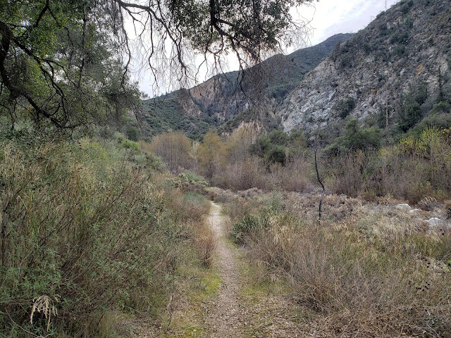
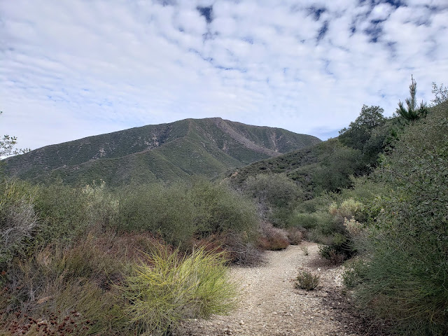
Ortega Trail
Inscription Along the Ortega Trail

It's easy to forget (or not even think about in the first place) that many of the hiking and recreational trails we use today follow routes established for very different reasons by those who came long before us. Game trails, ancient Native paths, and historic trails through the backcountry all serve as a substrate for a good number of contemporary trails used regularly by we hikers, backpackers, and mountain bikers. Examples abound. The Mt. Wilson Trail in the Angeles National Forest was established in 1864 to haul timber to Sierra Madre from the summit of Don Benito's mountain. It was also used to transport telescope parts to Mr. Harvard to be used in the first telescope (which was later relocated to Mt. Wilson). Now, hikers and trail-runners trod the old way primarily to get in a good, long day-hike to the summit of Mt. Wilson. The Cold Spring Trail in Santa Barbara was originally the main route leading into the Cuyama Valley from Montecito. Today, it is a pleasant, if not moderately strenuous hiking route to the Camino Cielo, Forbush Flat, and/or Cottam Camp.

And then there's the Ortega Trail (23W08) just north of the town of Ojai. Some sources claim that the trail was named after Jose F. Ortega who in 1895 established an 80 acre homestead at the mouth of canyon. Others suggest that the trail was established by famed vaquero and bear hunter extraordinaire Jose Ramon Ortega, descendent of El Capitan, Jose Francisco Ortega. Either way, it is rumored that the route was originally used to gain access to the upper Sespe from the Ojai Valley. Today the trail is an ORV route that connects the Maricopa Highway near the Holiday Group Camp site to the Cherry Creek area.

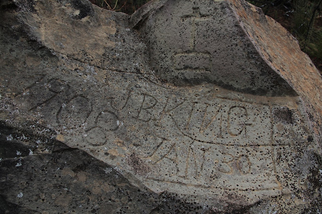
A mile or so up the rough trail there is a large sandstone boulder sitting trailside. Etched into the boulder is the inscription "JB King 1908 Jan 30." Immediately above the inscription is a calvary cross. There are no other carvings, inscriptions, or monuments in the immediate vicinity. So the questions that go begging about this inscription are (i) who was J.B. King, and (ii) why did he invest the time and energy into carving his name into this particular stone other than for the sake of notoriety?

I'm certainly not the first person to pose those questions. But to date, no one seemingly has come up with any satisfactory answers or explanations. Short of doing some serious historical research (which is quite difficult in these extraordinary times), the most comprehensive and readily available examination of this mystery can be found in a 1995 Los Angeles Times piece written by columnist Leonard Reed. Although Reed was not able to determine with certainty who the late-20th century Ortega Trail tagger was, he did narrow the field of potential candidates.

According to Reed's sleuthing, the rock carving is most likely attributable to John B. King of Nordhoff (now Ojai) who was a reverend at The Holiness Church and is now buried in Plot 192 of the Nordhoff Cemetery. Reverend King, his wife Katherine Linder King, and his son Robert Linder King are all long dead so any possibility of securing validation from them is non-existent. The Holiness Church is also gone. Established in 1885, the church occupied a wooden building at E. Topa Topa and Ventura Streets until approximately the 1920s. That building was either enlarged or reconstructed and is now occupied by the Ojai Valley Wesleyan Church.

So that is as much of an answer to the riddle as we are going to get unless and until something further can be unearthed. In the meantime, the Ortega Trail still affords the opportunity to walk back in history and see the backcountry much as it appeared during halcyon days of Ventura County's Californio past.

Ortega Trail

Saturday, April 18, 2020

Bear Liars I Have Met: Allen Kelley and the Capture of Monarch the Grizzly

Monarch the Grizzly
Illustration of Monarch the Grizzly from Allen Kelley's book "Bears I Have Met"

Ursus arctos horribilis. The dangerous and frightening Grizzly Bear. It's hard to envision now, but back in the 1800s when Southern California's streams were still boiling with native trout, the land was flush with game, and taking a walk in the wilds really meant taking a walk on the wild side, these behemoths freely roamed the local landscape. Not just one here and one there. Like everything else, they were here in large numbers. Estimates are that the mountains and forests of the Golden State once hosted up to 10,000 of these scary beasts.

In the backcountry of Ventura County, the North American Brown Bear was a regular fixture. And encounters with them were a common occurrence. Famed vaquero and bear hunter Ramon Ortega is reputed to have once seen 100 plus grizzly bear while traveling between the Rancho Sespe and the San Buenaventura Mission in Ventura. He is also said to have killed three grizzlies on one August day in 1882 in Matilija Canyon. In 1873, a grizzly chased a husband, wife, and infant into a tree while they were soaking in the Matilija Hot Springs. Other stories about run-ins with "the Grizz" abound.

Settlers rightfully feared the grizzly. Cattlemen and sheep herders loathed it. Like their contemporaries, the cattlemen and sheep herders of yore liked grazing their herds and flocks on the public range. Paying for that privilege in the form of lost sheep and steers, not so much. So the grizzly was shot, trapped, and poisoned by those whose agenda it was to sanitize the backcountry and rid it once and for all of those things that make the wilds wild. By 1889, the grizzly had effectively and systematically been extirpated from the landscape.

Enter newspaper magnate William Randolph Hurst. Hurst had a reporter who worked for the San Francisco Examiner named Allen Kelley. One day,  Hurst decided that he wanted to see a famed Grizz before they vanished from California completely. So he contrived a cockamamie scheme to send Kelley off to Southern California to capture one of the fearsome animals and bring it back alive to San Francisco. The project was fueled in part by Hurst's curiosity but mostly by his avarice and desire for attention. Kelley had zero experience trapping bears, but that was far more experience than the rest of Hurst's men had, so he was assigned the task.

Allen Kelley

Kelley's search for a grizzly brought him to Ventura County. There, in June of 1889, he assembled an expedition comprised of roughly a dozen "knowledgeable" locals, a couple of Native Americans, and two gear-laden donkeys and headed for the hills. The quest began with much fanfare as the rag-tag crew marched down Telegraph Road and out of Santa Paula toward the Sespe.

Kelley's route into the deep Ventura backcountry took him up Tar Creek to Squaw Flat, over to the Stone Corral, down into the Alder Creek drainage, over to the Sespe Hot Springs, up the Johnston Ridge to Mutau Flat, through the Lockwood Valley, and ultimately onto the southern flanks of Mt. Pinos. There, Kelley and his boys spent the summer trying without success to coax a grizzly bear into one of a number of traps they had built.

This is where the tale get murky. And it gets murky because Kelley, a supposed journalist whose job it was to recounts events accurately and truthfully, instead wrought confusion and suspicion by telling two very different stories that call into question his veracity and make it virtually impossible to really know what happened next. One story appeared as a multi-page expose that Kelly penned for and that was published in the San Francisco Examiner on November 3, 1889. The other story is the one he told many years later in a book he authored titled "Bears I Have Met - And Others" that was published in 1903. Both of these stories recount how Kelley ultimately captured the famous grizzly bear, now memorialized on the California state flag, known as "Monarch." But in the former story, Kelly claims Monarch was captured near Mt.Pinos in Ventura County. In the latter story, Kelly changed his tuned and asserted that he acquired Monarch from a "syndicate" that had captured the bear near Mt. Gleason in Los Angeles County.

Local Ventura County historian Charles Outland, author of the compelling read "Mines, Murders, and Grizzlies: Tales of California's Ventura Back Country," contends that the yarn Kelley wove in his 1903 book was a complete fabrication. But that view is not unanimous. In his book "The San Gabriels: The Mountain Country from Soledad Canyon to Lytle Creek," noted Southern California historian John Robinson, dismissed Outland's view as having "some support and a lot of conjecture." The Santa Clarita Valley Historical Society also apparently views Kelley's book as the last, authoritative word on the subject despite his previously published San Francisco Examiner article ("Various internet sources say Monarch came from the Ojai area; this is incorrect, as Kelly himself tells us.").

It's easy to assume that provincialism and/or pride might be at work here. Outland was from Ventura County and Robinson was from Los Angeles County. So each may have been motivated, whether consciously or not, to see Kelley's stories through a particular lens. And each may have then interpreted the facts so as to arrive at a conclusion that was consistent with the outcome desired. I don't know. I never met Charles Outland. I did meet John Robinson once and asked him about Monarch. He was unyielding in his belief about where Monarch was captured. So that leaves us with the conflicting narratives that Kelley published and the discord those narratives have sown among historians. In light of that, both of the tales Kelley told about Monarch are worth examining.

The 1889 San Francisco Examiner Article

According to the San Francisco Examiner article he penned, after getting skunked on Mt. Pinos, a clearly frustrated Kelley broke camp, "built several traps in the mountains near trails frequented by bears," and then changed locations to "the unsurveyed and unnamed peaks between Castac lake and the Liebre Mountains." That would have put Kelley and his troupe roughly in the northwest corner of Los Angeles County. Here, Kelley turned his attention for awhile to trying to capture a notorious grizzly that was known to frequent "General Beale's ranch" (known today as the Tejon Ranch) and to kill cattle with impunity and abandon.


Then, "one morning" (Kelley doesn't say when or exactly where they were), one of Kelley's men returned to camp to inform him that a dead steer had been found within 100 yards of an unfinished trap. All haste was then made to complete the trap in the belief that the murdering animal would return that night to finish off his meal. To that end, one of Kelley's men "rode out to Gorman's station to get some nails and honey, while the Correspondent (Kelley) paid a visit to one of General Beale's old corrals and stole some planks to make a door." Kelley then dragged the materials up the mountain to complete the trap, Just before dark, his man returned from Gorman station with honey and other provisions, but the hour was late so the trap could not be finished before darkness fell.

The next day, the trap was completed, but by some "ludicrous accident" it was destroyed thus guaranteeing that "a bruin would never be caught in it." Kelley's men then returned to Ventura, leaving him alone in the mountains, where he then had an exciting encounter with a grizzly, but still no success in capturing one.

In terms of trying to decipher where Kelley ultimately captured Monarch, this part of the story is key. This is what Kelley told his San Francisco Examiner readers next:


The bait scattered around this particular trap was ultimately discovered by four bruins, two of which were medium-sized, one of which was large, and the fourth which was enormous. As it turned out, the latter was not Monarch, but instead "Six-Toed Pete," a "cinnamon." However, a big grizzly soon also discovered this particular trap which Kelley tells us lead to a moonlight confrontation with Six-Toed Pete. The grizzly came out the victor and to him went he spoils that had been placed for him near the trap.

After his triumph, the big grizzly became less suspicious and cautious about approaching the bait Kelley and his men set out for him. Consequently, the bait was gradually moved closer to the trap door every day until finally a chunk of meat was placed on the trigger inside the trap. Then one morning,  Kelley awoke to find that he had finally captured the massive grizzly bear known as Monarch. The precise location at which Monarch was captured was not included in Kelley's exciting newspaper narrative, but the headline pronounced:

He Was Trapped in Ventura County After a Terrific Struggle and Secured with Massive Iron Chains - It Was  Hard Battle but Not a Man Was Hurt - The Long Journey Over Almost Impassable Mountains Before He Was Safely Landed in San Francisco - Getting Used to Captivity, but He Needs a Good Strong Cage All the Same

The "Bears I Have Met" Version

Fourteen years after he wrote the Examiner article, Kelley published his book in which he included an account of how and where Monarch was captured. In this version of the story, Kelley says that after an unsuccessful summer spent on Mt. Pinos, Hearst became impatient and recalled him back to San Francisco. Kelley refused to return to the City by the Bay bearless, so Hearst fired him on the spot. Undeterred, Kelley terminated his useless helpers, discarded "all the advice that had been upon unloaded upon me by the able bear-liars of Ventura," and struck out on his own for "General Beale's range in the mountains west of Tehachepi and above Antelope Valley" where he attempted without success to trap the a cagey grizzly named "Pinto."

Then, in late October, Kelley became aware that a grizzly bear had been trapped by a "syndicate" on Mt. Gleason. So Kelley left Pinto to his own devices and traveled to the Mt. Gleason area where he met with a "Mexican" named Mateo and negotiated the purchase of the bear that became known as Monarch. Kelley then had a box built to house his bear and transported the beast to San Francisco where he sold it to Hearst who put it on display in Golden Gate Park. And the other story Kelley had told years earlier? He downplayed the conflicting narrative by dismissively claiming:

"The newspaper account of the capture of Monarch was elaborated to suit the exigencies of enterprising journalism, picturesque features were introduced where editorial judgment dictated, and mere facts, such as the name of the county in which the bear was caught, fell under the ban of a careless blue pencil and were distorted beyond recognition."

Are You Lying Now or Were You Lying Then?

Given the radically different tales Kelley told, it is fair to ask which one of them is true. Stated differently, one might ask whether Kelley was lying in 1889 or 1903.

Based upon the San Francisco Examiner article, it's difficult to know exactly where in Ventura County Monarch was supposedly snared. The piece itself merely says that Monarch was finally apprehended on a mountain that was not infested with domesticated cattle and sheep and on which there were no acorns to forage. And this statement appears in the narrative while Kelley in admittedly in the Liebre Mountains near present-day Lebec. The only place in the article where Kelley explicitly states that Monarch was collared in Ventura County is in the headline. Not much to go on.

But the yarn Kelley wove in his book about Monarch's capture is even more problematic. First, 14 years passed after Kelley penned the Examiner article before he decided to correct the record. That extended delay calls into question the truth of the "correction." On top of that, he had a book to sell. Rehashing the story he already had told wasn't going to help in that regard.

Second, Kelley's stated reason for the supposed inaccuracies in the Examiner article are too flimsy to believe. Hearst was well known as a purveyor of yellow journalism, and it is not hard to imagine that he and his editors took some creative license with Kelley's story before it was published. But what possible "exigencies of enterprising journalism" were served by changing the name of the county where Monarch was captured from sexy Los Angeles County to backwater Ventura County? Particularly, since the expedition had spent its entire time in the latter county? The explanation just doesn't hold up under scrutiny.

Third, in his book, Kelley tells us that Hearst unceremoniously fired him after several unsuccessful months on Mt. Pinos when Kelley refused to terminate the search and return to San Francisco. Despite this, Kelley ventured forth on his own, spending several additional months tracking Monarch, purchasing him from the syndicate, transporting him to San Francisco, and then writing a detailed, multi-paged expose for Hearst and his publication about his exploits.Why would he do that if he had been fired? It simply isn't believable.

Lastly, the language Kelley used in his book is telling. It suggests that he was more motivated by grinding his axe and depriving Ventura County of notoriety than he was in actually telling the truth. The local men Kelley hired to assist in tracking and capturing a grizzly are dismissively described as "the able bear-liars of Ventura." Kelley bemoans the advice and recommendations he received from his "ingeneous, but sedentary" and "over-paid" assistant. The whole approach smacks of score-settling as opposed to objective and truthful reporting. And the "able-bear liars" slur that he leveled against the Venturans he hired is ironic given the fact that Kelley himself must have lied about the whole affair either in 1889 or in 1903.

So, what can be said of where Monarch was actually captured? There is certainly more resources available that can be consulted in an effort to ferret out the truth, but if those resources solved the mystery we would already know about it. But based solely on the Examiner article, Kelley's book, and a few other articles, I don't know that anyone can authoritatively say whether Monarch was captured in Ventura County, Los Angeles County, or some other county (a newspaper entry from the Ventura Observer dated December 9, 1891 indicates that Monarch was actually captured in Kern County - see snip below). What can be said, with apologies to the late John Robinson and the Santa Clarita Valley Historical Society, is that the generally-accepted story that Monarch was captured in Los Angeles County near Mt. Gleason is dubious at best.

Friday, April 10, 2020

The Vagina Rock Monologue

Chumash Bedrock Mortar

I know an old man. Actually, its probably too much to say that I know him. Or that he knows me. We've passed each other on the trail a number of times and have stopped occasionally to chat with one another. That ultimately happens when you repeatedly see the same folks in the same location doing the same thing you are doing. So this guy, he's is a familiar face to me even though I may not be to him.

My trail acquaintance is what you might call "learned." He is formally trained and educated and holds multiple advanced degrees to prove it. He also knows the land. That comfortable familiarity comes from years of walking, eating, breathing, working, and observing the trails. So he is both book smart and street (or, more appropriately "trail") smart.

Many months ago, this scholarly old gentleman told me a secret. The trail we were trodding crossed native land. The ancestral home of the Chumash people. For thousands of years before the European invasion, conquest, and forced assimilation, the Chumash called this place home. They roamed it freely, unencumbered by the disapproving eyes of their more advanced, religiously superior, and lighter-skinned brethren. That, of course, was not the secret. That was just common knowledge. What wasn't and isn't common knowledge was what he told me next: that there was a ceremonial fertility stone close by that was hiding in plain sight. And in the immediate vicinity of that stone was other evidence that the location was regularly used by the Chumash people. He didn't elaborate on what that other evidence was and I didn't prod him further. If he had wanted me to know, he would have told me.

Secrets like these are closely guarded by the people that know them. And for good reason. Many a site has been despoiled by those who believe it clever or cute to scratch their name into or tag a pictograph panel. Or to steal artifacts. So my friend did not disclose to me the location of this particular stone. And I, in turn, will similarly refrain from disclosing its location.

But after that encounter, I was intrigued. So I starting looking. I scanned the topography trying to see the land as the Chumash would have seen it. I looked along ridgelines, into the canyon bottoms, and at the various rocky prominences that dot the area. There were a million rocks out there, any one of which could in theory be a candidate. But eventually, I spotted a large sandstone protuberance. It didn't immediately beckon to me, but if I looked at it from a certain angle, it kinda, sorta resembled a vagina.

So I decided to investigate. There is no path to the vagina rock. It required some cross-country travel that involved a bit of bashing through our infamous chaparral to get there. The closer I got, the larger the rock got. And the less it resembled lady parts. I started thinking that perhaps I was on a fool's errand. But I was already invested this much in the task so it made no sense to turn back. Thus, I pushed forward.

When I finally arrived at my destination, I was struck by the enormity of the sandstone monolith. Distance alters one's perspective, but I was still surprised at how badly I had misjudged the size of this thing. And it was far too large, and its sides too sheer for climbing upon. So I doubt that is how the Chumash used this particular fertility aid. 

On the backside of the stone, I discovered what the old man on the trail must have been alluding to: a smattering of bedrock mortars. A short distance away, at the base of another sandstone monocline, surrounded by sycamore trees, I found another cupule embedded in the rocky ground. Nearby was a smooth, rounded stone that resembled a pestle. It did not appear that this particular rock was "the" pestle that went with this particular mortar (or that it was a pestle at all), but it was representative of the stony implements that litter the area and were available to, and leveraged by the Chumash people. I found no midden, but perhaps I'm too anthropologically challenged to have even noticed.

Chumash Bedrock Mortar

Chumash Bedrock Mortar

Chumash Grinding Stone

Satisfied, I sat for awhile in the cool of the shade with my back against the sandstone wall trying to imagine native peoples grinding dried seeds and acorns for wiiwish. It's a romantic ideal, particularly when viewed through the prism of 21st century advantage and comfort, but I wondered about the difficult reality of the task. I also wondered about the vagina rock and how, when, why, and by whom it was used. Perhaps as a descendant of colonizers and occupiers, it is not my place to know. And perhaps it wasn't even my right to have visited this place at all.

That same thought came to the forefront of my mind some days later when I inexplicably developed a severe case of dermatitis on my legs. It is possible that I passed through some poison oak on my way to the fertility stone, but I've been around enough poison oak to recognize it. And I didn't see any on my way to the stone. And I've had poison oak more times than I care to remember, and this didn't particularly look to be poison oak. So I allowed for the possibility that my flare-up was spiritual and/or cultural retribution for visiting a spot at which I was not wanted, had not been invited to, and had no business being at. Of course, that thinking could have just as easily been my hyper-active imagination being fueled by occupier guilt, but I'm not taking any chances. I will for now let this place be.

Monday, April 6, 2020

In the Footsteps of Grizzlies and Banditos

Dark Canyon

From a town known as Wheeling, West Virginia
Rode a boy with a six-gun in his hand
And his daring life of crime
Made him a legend in his time
East and west of the Rio Grande
~Billy Joel, The Ballad of Billy the Kid

As far as I know, legendary outlaw and bank-robber extraordinaire Billy the Kid was never in the San Gabriel Mountains. He was too busy shooting up saloons and rustling cattle and killing lawmen in Nuevo Mexico to bother coming further west. And even if he did have aspirations to visit the Golden State, those were cut short on July 14, 1881 when Lincoln County Sheriff Pat Garrett ambushed Billy in a house in Fort Sumner, New Mexico and put a bullet in his brain. Thus came the swift end for Henry McCarty aka William H. Bonney aka Billy the Kid.

But the San Gabriels didn't need Billy the Kid. It had a robust assemblage of banditos and gun-slingers and desperados all its own. One of the more notorious was the gentleman and chivalrous outlaw Tiburcio Vasquez who claimed that his crime spree was to avenge the numerous injustices committed by invading Anglos against native Californios. Vasquez and his gang were all over the San Gabriel range and several places memorialize or bear witness to that fact (e.g., Bandido and Horse Flat Campgrounds, Vasquez Creek, Vasquez Rocks).

One of Vasquez's more infamous exploits was the raid on the Repetto ranch which was located in southeast Los Angeles in what is now Monterey Park. Alexander Repetto was an Italian sheepherder who Vasquez was informed was flush with cash after having recently sold one of his flocks. So Vasquez and his boys hatched a plan to relieve Mr. Repetto of his burden. Claiming to be sheep-shearers, they came to the Repetto ranch looking for work. But Repetto was a sharp cookie with a keen eye who saw through the ruse and called Vasquez out. Admitting that he was in fact not a sheep-shearer, but a gangster, Vasquez tied Repetto to at tree, demanded $10,000 of him, and threatened to hang him if he did not comply. But Repetto didn't have the money. He had spent most of it. And what remained was on deposit at the Temple and Workman Bank in downtown Los Angeles. So an alternate plan was conceived. Vasquez would force Repetto to write a check that his nephew would carry to the bank, negotiate, and then return with the proceeds. In a piece titled "The Hunt for Tiburcio Vasquez: A Chase Through a Californio's L.A., " Robert Peterson describes what happened next:

"When Repetto's nephew arrived at the bank, he was so nervous that the banker, Francis Temple, became suspicious and contacted the Sheriff. Upon further questioning the nephew broke down and tearfully revealed the whole story. The Sheriff immediately started assembling a posse to capture Vasquez. At this point, the nephew became worried that the Sheriff's involvement might result in his uncle's death. He managed to convince the banker to give him 500 dollars in gold and returned to Repetto's house, before the posse, to give the money to Vasquez. When the Sheriff's posse approached Repetto's house, Vasquez and his men mounted up and started racing north towards present day Pasadena."

Vasquez's escape route took him up the Arroyo Seco, into Dark Canyon, up to the old Soledad Road grade at the crest (present day Grizzly Flat Road), and then down into Big Tujunga Canyon via Grizzly Flat and Vasquez Creek (roughly, the present-day Grizzly Flat Trail). The ride down to Big Tujunga was rough, steep, and overgrown with Buckthorn, and Vasquez lost a horse and his revolver on the way down. Years later, a 16-year old kid named Phil Begue from the City of Tujunga, found Vasquez's saddle and his revolver still bearing the initial "T V" cut into the barrel.

For a nice write-up of the raid by Vasquez on the Repetto ranch by legendary Southern California historian John Robinson, go here: http://www.lawesterners.org/wp-content/uploads/2013/10/149-DECEMBER-1982.pdf


Given its historical significance, I've wanted to see Grizzly Flat and the trail leading to it up Dark Canyon from Big Tujunga for awhile, but all the reports I had seen were that is was impassable and/or choked with poison oak. Me and poison oak ain't friendly. So I never went. Then one day, I read a report that the Grizzly Flat trail had been worked and was clear all the way to the divide. That was all the motivation I needed.

I started from Stoneyvale at Vogel Flats. The parking lot was empty save for one van near the trailhead. Two ladies in hiking gear had just come down trail and were loading their gear into the van. A good omen. As I passed them, they asked me where the trail went. They had followed it a short distance until it petered out in a tangle of growth at the stream and then turned back not seeing a way forward. A bad omen. I pushed on having to see for myself.

A short distance later I saw for myself. The path seemingly ended abruptly in a boggy, overgrown mess along Big Tujunga creek. This wasn't right. The reports I had read indicated the trail was passable. So I rock and log-hopped across the creek to left-hand side, bashed through a stand of Arundo donax, and the trail magically reappeared. From this point until the path tacks south at Silver Canyon and begins the climb to Grizzly Flat it was easy and open walking.

Lower Grizzly Flat Trail

Lower Grizzly Flat Trail

Grizzly Flat Trail

Then things began to get more interesting. As the trail starts to climb what I suppose is technically Dark Canyon, it gets steep, rocky, and narrow. Not impossibly steep, but steep enough to make you work. As the climb began, I looked for the Windsor benchmark (2094) without luck. It must be buried in the very thick brush that blankets the hillsides here.

Further up, stiff brush began to encroach on the trail poking and grabbing me as I passed. Then there were a number of fallen trees that had to be negotiated. Again, nothing too difficult, but enough to add some spice to the outing. But the higher I climbed, the more ducking and bending and crawling on, over, and around vegetation I had to do. Fortunately, none of it was of the poisonous oak variety. Just below and west of Grizzly Flat, in the dark and cool drainage that must be Dark Canyon (none of the maps that I've looked at are labeled), I heard rustling in the underbrush ahead. Since I was just shy of Grizzly Flat and in the deep recesses of the San Gabriels, I immediately assumed Ursus americanus californiensis. So I started hooting, hollering, and clapping my hands in a pathetic attempt to scare off the unseen beast. Then two guys came around the bend on the descent making me the fool. They didn't say anything but they knew. And I knew they knew. I asked them if they had gone all the way to the ridge, but they demurred. They said they got tired of bush-whacking so were beating a retreat back to the trailhead. Another bad omen.

Then I popped out into the clear and the sunshine at Grizzly Flat, named after the Grizzly Bears that once called the Angeles National Forest home and reputedly favored the Big Tujunga region. I've heard that before the Station Fire, Grizzly Flat was nice. Now, it is not much more than wide-spot on the trail. I stopped for a spell, investigated the water tank, hydrated, then pushed on.

Grizzly Flat Trail

Grizzly Flat Trail

Grizzly Flat

Grizzly Flat Water Tank

Here, the trail morphs into Grizzly Flat Road so I was optimistic that the traveling would become easier. But while the way did in fact open up, and the path did become wider, forward progress definitely did not become more effortless or simple. It seems Spanish Broom, a beautiful, non-native invasive, has a particular affinity for the area and it has aggressively colonized the place. It crowded the road to the point of being almost impassable at times, and I spent the next half-hour or so ducking under, around, and through massive clumps of the offending stuff.

Finally, I reached the divide separating Big Tujunga Canyon from the Arroyo Seco. This was the exact spot where 100+ years earlier, Tiburcio Vasquez finally shook Sheriff Rowland from his tail after the Repetto Ranch raid. The spot offers expansive views down Dark Canyon and into the Big Tujunga Creek drainage. Here, I found a spot to admire the fine scenery, shed my sweat-soaked top, dry out, and contemplate the historical significance the piece of ground on which I was sitting. After I had my fill, I hoisted myself up and then retreated back into the wilds of Dark Canyon that was once the haunt of both bandits and grizzlies.

Upper Grizzly Flat Trail

Upper Grizzly Flat Trail

Big Tujunga Creek