Friday, July 21, 2017

Dharma-Bumming the Southern Sierra


I felt like lying down by the side of the trail and remembering it all. The woods do that to you, they always look familiar, long lost, like the face of a long-dead relative, like an old dream, like a piece of forgotten song drifting across the water, most of all like golden eternities of past childhood or past manhood and all the living and the dying and the heartbreak that went on a million years ago and the clouds as they pass overhead seem to testify (by their own lonesome familiarity) to this feeling.
-Jack Kerouac, The Dharma Bums

The closer you get to real matter, rock air fire and wood, boy, the more spiritual the world is.
-Jack Kerouac, The Dharma Bums

Sometime last week, I glanced at the calendar and realized it was mid-July. Of course, I knew what date it was in a cognitive awareness sort of way, but it hadn't actually dawned on me that we were half-way through the summer already. Anxiousness washed over me with the subtlety of a flash flood. Summer, the season of the Sierra, was slowly receding from me. The promise of warm days and cool, starry nights at altitude was slipping away.

Mildly panicked, I resolved then and there that a trip to Lone Pine was in order. Not on some future date after meticulous organization, relentless planning, and exhaustive consultation. What I had in mind was something immediate. An impulsive, chaotic, and messy affair that I'd make up as I went along. When I mentioned my idea to my skeptical better half, I was told I was forcing the issue. And of course I was. That's the only way these things ever seem to happen.

So two days later, there I was headed north by myself, crossing the upper Mojave as the devilishly hot desert air came blasting through my open car windows. Those windows weren't open by choice, but rather by necessity as the air conditioner in my car had recently quit me. In some respects, that's understandable I suppose given the fact that I drive a 2009 Honda Civil Si with 187,000 miles and a flaking paint job. But still, the inability to conjure artificially cool air on demand made the journey an exceedingly hot and uncomfortably noisy affair. Through the haze of time, this will be the stuff of warm memories and embellished bar-stool reminiscences.

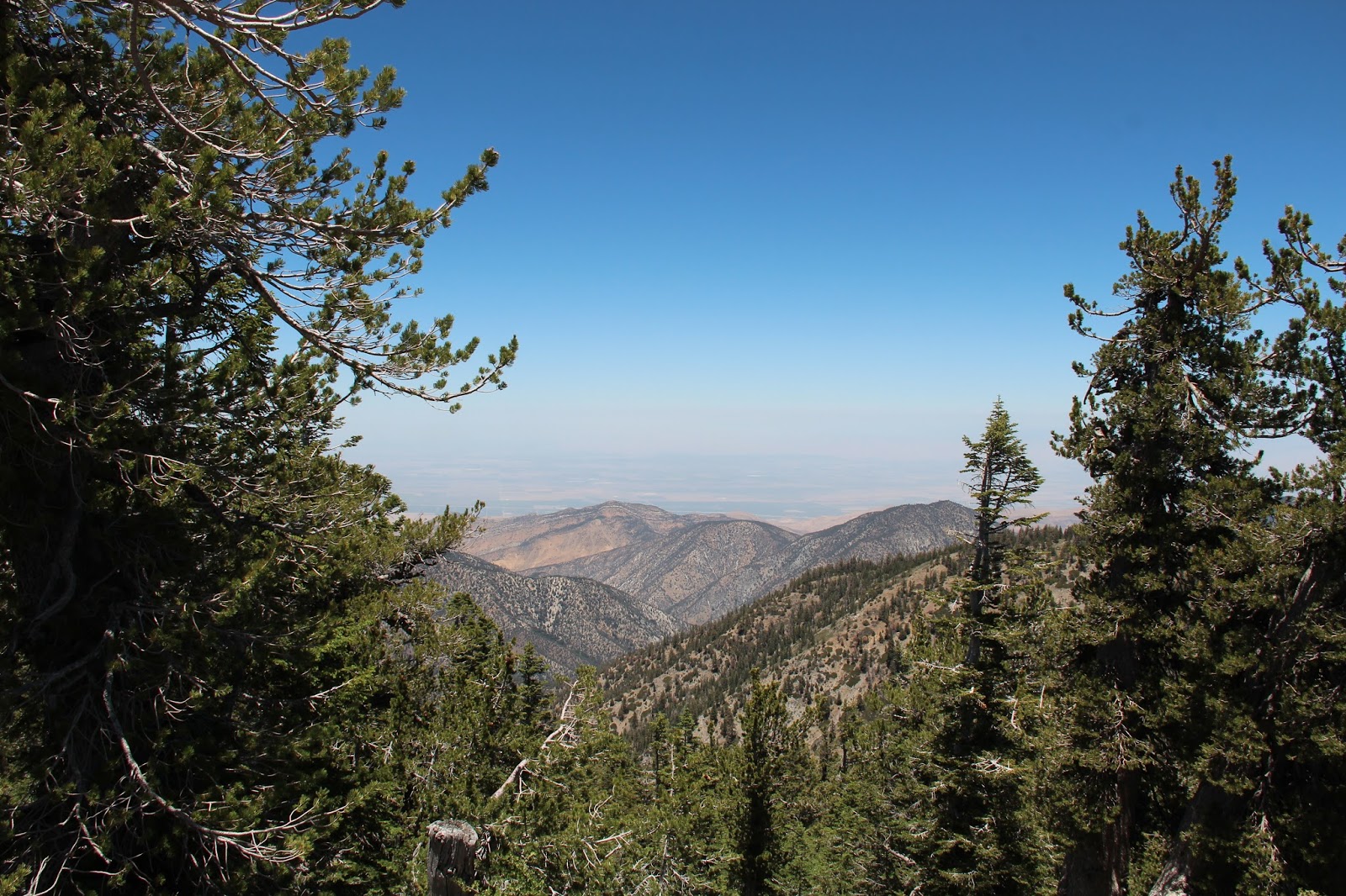
Three hours in I made a hard left and tacked west up narrow and winding Lubken Canyon Road. Here, the landscape immediately and dramatically changes from burnt desertscape to a velvety, green paradise that is watered by gurgly Lubken Creek. But Eden is a very small and private place that is not shared freely by its chosen inhabitants, so I soldiered on into the parched and sun-baked promised land that is the Alabama Hills. Finding a suitable place to call home for the evening, I set up camp, built a fire, and then settled in as the sun mercifully slid behind the mountains and darkness crept over the fantastic and grotesque rock formations for which these hills are justly famous.

It would not be odd in the least to wonder about how the name "Alabama" became appended to these eastern California hills. I have thought about that myself. Apparently, the area was named by local prospectors in honor of the CSS Alabama, a legendary Confederate battleship that was successful in raiding Union merchant and naval ships during the Civil War. The CSS Alabama was ultimately sunk in June of 1864 by the USS Kearsarge for which the Kearsarge Pass, Lakes, and Pinnacles are named. But fret not. The CSS Alabama may be gone, but it is not entirely forgotten in these parts. 150+ years and counting after the end of bloody hostilities between the north and south, a bit of the Confederacy spirit can still be found in Lone Pine where the "Stars and Bars" is proudly displayed over certain bars and hung from scattered homes.

Around 5:30 a.m the next day, the sun reappeared over the Inyo Mountains and bathed the Sierra in warm amber. This is a spectacular phenomenon I never tire of, although I wonder if the local even see it anymore because it is so commonplace. Foregoing coffee and the urge to linger, I broke camp and immediately drove to the Cottonwood Lakes trailhead at 10,000 feet where my thermometer told me the outside temperature was cool and comfortable 51 degrees. As I pulled in, I congratulated myself on the early arrival, smug in the belief that it would secure me a convenient place to park and ample space for my smellables in the bear box. Much to my dismay, however, the parking lot was completely full, forcing me to the sad overflow area near the equestrian camp, the hiker's equivalent of the kids' table.

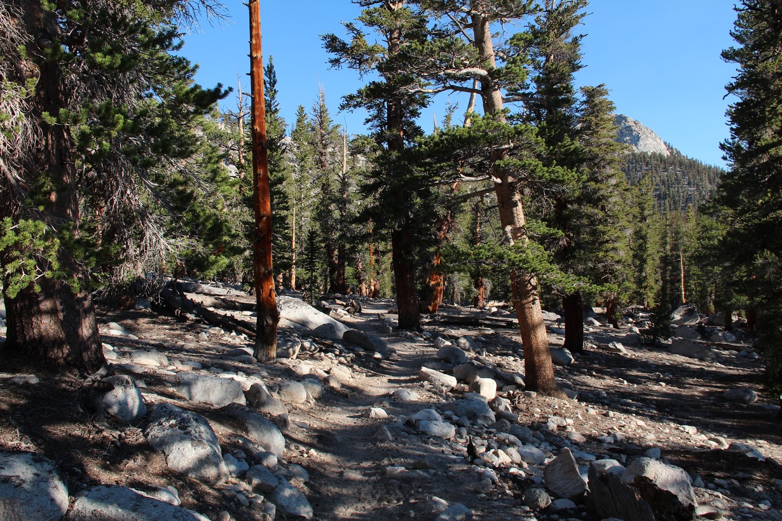
Although the parking lot was full, the trail was empty as I silently made my way through the forest noisily gasping for air. Being a lowlander all these years has rendered me altitudinally challenged. But the weather was so perfect, the creeks so full, and the scenery so fine it was easy to ignore my tortoise's pace and the fact that my legs felt like lead.

Five miles or so in, the trail crests a low rise and suddenly I was in an enchanted, high-altitude basin hemmed by blazing white granite and splattered with sapphire lakes. Mt. Langley towered 14,026' to my right. Cirque Peak pierced the flawless sky to my left. Before me sat a surprisingly verdant bowl studded with boulders and bisected by flowing water. Ah yes, this was the wonderland I had journeyed all this way to bathe in.

There are many foot-paths that cut through this justly popular basin. I opted to follow the one that passes between Lake No. 3 and the unnamed "pond" to the northeast. Water from snow-melt roared into Lake No. 3 at its inlet on the northwest end. As I neared Lake Nos. 4 and 5 nestled beneath Army Point Pass, clouds of marauding mosquitoes swarmed. It's been a record water-year in the Sierra and the mosquitoes are taking maximum and frenzied advantage of the situation. The only way I could escape the blood-thirsty little creatures was to stay on the rocks and away from any vegetation. I now know what it must feel like to be a Caribou on the Arctic Plain in the spring time.

But biting midge-like flies are a small price of admission, so I offered up some of my bodily fluids and luxuriated in the resounding silence of my personal nirvana. Afterwords, I back-tracked through the basin, veering south for a quick visit to the appropriately named South Fork Lakes, before reluctantly making my way back to the trailhead and what passes for reality.

Back at my campsite in the Alabama Hills, the late-afternoon heat was unrelenting. As a diversion, I tried to read, hoping for relief as the scorching sun crept west across the sky. But I despise the heat and soon grew impatient with how slowly sunset was approaching. So I loaded up my gear and started back for home.

The air conditioner in my car wasn't working any better on the way back than it was on the way up. So of course I had all the windows wide open once again. Somewhere along that tedious and lonely stretch between Olancha and Mojave ferocious cross-winds began to buffet the car. Then, a couple of closed-cell foam pads in the back seat that I keep in a plastic garbage bag began to levitate. I sensed impending calamity and began bringing up the windows in earnest, but the foam pads took flight. They momentarily got stuck as the passenger side window pinched around them, but then they were gone. Out the window to join the other sad detritus along the highway median. Stunned, I slowed some to quickly considered my options as other cars passed me on the right, their occupants staring at me quizzically. A quarter-mile or so later, I brought the car to a stop after I had processed the curiosity of what had just happened. Then I walked in shame and embarrassment up the freeway in the 103 degree heat to retrieve my garbage-bag belongings. Ah yes, another life episode to ultimately be remembered more fondly than deserved through the prism of hindsight and the bottom of a beer stein.

When I finally arrived home in the fading light a few hours later, I felt like Ray Smith from Jack Kerouac's The Dharma Bums. I didn't feel like doing much of anything but lying down and remembering it all. The woods do that to you.


Native Trout


Tuesday, July 11, 2017

David Stillman Speaks


David Stillman is a legendary and prolific explorer of the southern Los Padres National Forest. He is a walking encyclopedia on the forest whose knowledge was gained from raw experiences on, but mostly off the established path. I don't think it much of an exaggeration to say that David Stillman knows more about the southern Los Padres than all but a very select handful of folks.

From 2008 to 2015, David actively maintained a blog (http://davidstillman.blogspot.com) that catalogued his numerous explorations of the forest. Then, in mid-2015 his voice inexplicably fell silent. He posted no more. As Jack Elliott appropriately observed, "And like that, poof, he's gone. Underground. Nobody has ever seen him since. He becomes a myth."

Well I chased the myth down to find out what he is up to these days. As always, David was very accommodating of his time, free with his information, and tolerant of some of my dumb questions. Here's what David had to say:

Wildsouthland (WS): First off, how are you David? Are you still healthy, happy, and wise?

David Stillman (DS): Happy? Generally. Healthy? I won’t bore you with the numerous orthopedic insults that afflict me, but I did tear up my achilles in April and that’s had an impact on my abilities. Wise? It’s a work in progress.

WS: Tell me what you’ve been up to for the past 2 years?

DS: I’ve been pretty busy. Death Valley, the Mojave, the southern Sierra, Arizona,
Nevada, and Utah. I’ve been ranging pretty far and I find that a change of scenery is
pretty refreshing.

WS: Are you still climbing peaks, busting brush, and trodding the trails of the SLP?

DS: Um, the short answer is “Not so much.” I recently logged some time in the Miranda Pines/La Brea Canyon part of the San Rafael, and there was a nasty slog off trail somewhere on the south side of Sierra Madre Ridge that got a bit sporty. I guess you could say I still go out and get torn up. But summits, no. I’ve already done the SLP summits that interest me.

WS: Where have you been recently?

DS: The last outing, a couple weeks ago, involved waking up at 03:00, driving to Lake Isabella, hitting up some rock art sites in the Walker Basin and topping the day off with a 12 mile hike in the woods above the Lake. Then driving home. That was a rewarding day.

WS: Let’s get down to what everyone wants to know. For years you published a very informative blog about your adventures in the SLP and beyond. In 2015 you stopped publishing and went on a temporary hiatus which appears to now be permanent. A lot of folks were bummed about that, including me. Can you tell me what prompted you to stop publishing?

DS: I can. It’s complicated, but let me try to reduce my reasoning to something that makes sense. On one hand, I had this blog going, which was becoming popular for a whole range of reasons. It had taken off to the degree that a local mountain rag can. On the other hand, it wasn’t fun anymore. I began to understand that the need to generate new material, to stay popular and relevant, and to one-up myself every time I went out was really not what I wanted to be about anymore. It started reminding me of Caesar; Vini, Vidi, Vici and all that. I just gradually started to feel like the blog, and not my time in the woods, was what was more important. When I finally recognized what these feelings were, I decided it was time for a change.

WS: How much did controversies over access to certain locations and the constant criticism of internet trolls play into your decision?

DS: The B.S. definitely played a role. Along with a growing readership I attracted plenty of people who were watching what I was doing through the eyes of their own agenda. There weren’t many outright trolls, but organizations like the Wind Wolves Preserve, and the US Forest Service were paying pretty close attention to where I went and what lines I crossed. Also, a particularly vocal shade of archaeological academia made it their mission to equate what I was doing vis-a-vis rock art with the vandals out there. The way I saw it, I was going to go see these places whether they liked it or not, and the fact that I never gave out directions or coordinates or posted landscape shots
that others could use to find sacred places wasn’t good enough for them. The way they saw it, anybody not sanctioned by themselves had no business seeing or appreciating these sites.

WS: Do you ever see yourself starting back up again?

DS: That’s the big, bad question again. To this day, every time I go out and come back with great photos and a solid tale I want to post. The bug is still alive, but I also realize that I’d be less active in the Los Padres, and I certainly wouldn’t be out there doing 25 mile peak bagging days. Mostly because I don’t feel I have anything to prove. I’m content that I left a record of achievement in that forest that stands on it’s own.

WS: Even though you’re not presently publishing, the archival content of your blog is still available on-line for folks to access. It’s very helpful information to those of us that like to explore the SLP. What are your plans for your blog? Do you intend to keep it accessible into the future? If not, what is to become of its content?

DS: I intend to maintain the blog as it is today. I basically consider that content to be in the public domain.

WS: Have you ever thought about putting that content together as a book?

DS: An interesting question, but no, I haven’t considered that.

WS: How and when did you first get into exploring the SLP?

DS: My father was a naturalist/biologist out of UCSB. He introduced me to the Los Padres. Mostly by dragging me here and there to see animal poop. Seriously though, I remember hiking into and camping at White Ledge Camp under Topatopa when I was 5. I did Chief Peak when I was 10, with that old sadist Glenn Hackworth. Being in an active Scout troop really set the hook. The first time I hiked Whitney I was 12. I ended up doing big summer road trips with a friend. We’d save all year and take off for the summer, we were 16, 17 years old. We’d hike in Montana, Idaho, Washington, New Mexico. Past that I was heavy into rock climbing and mountaineering. I moved back to the Central Coast in 2000 and resumed hiking in the SLP in 2005.

WS: How did you gain your extensive knowledge about the forest? Did you gain it primarily from books or from raw experience?

DS: I just went. But I will say I have a boner for maps, and I’ve never paid much attention to where the trails are. They’re just lines on the map.

WS:  Who were some of the folks that you looked to, and still look to, for guidance and information about the SLP?

DS: Uh, I just figured this shit out on my own. It wasn’t until later, when the blog became a thing, that I started meeting other SLP people of note.

WS: I don’t know these folks, but guys like Craig Carey, Jack Elliott, Mickey McTigue, Bardley Smith, those are some of the guys I consider giants of SLP knowledge and adventure. Do you know all of those guys? Are they still exploring and writing, or are they “retired” like you?

DS: I know of McTigue, but have never met him. Bardley I’ve met a couple times. He’s a guy I wish I could get to know better. He’s probably got some good stories. Craig is heavily involved in the forest, both through the Scouts and with the USFS. He’s done some really good things and I admire him. Jack Elliott is still a close mate. He and I get out every couple months for something that usually turns out amazing. In a word, Jack is stalwart. And a good mate.

WS: Who, if anyone, do you see taking up the mantle you have laid down? Any young SLP up-and-comers that we should know about? Who are the next generation of SLP prophets?

DS: No idea. I don’t really care what other people are doing. I’m not on social media and I rarely look up anything to do with the Los Padres because I already know everything I personally need to know about it. I know I sound like a dick but I’m just not a social person. I will say that there are always tough people doing awesome things in that forest.

WS: Shifting to your other interests, I know you are interested in native rock art have documented a number of Native American rock art sites. How did you get involved in that?

DS: I guess it was always there. My grandfather had grown up in Santa Barbara and had collected baskets, points, tool and the like. We call that looting nowadays. I visited the Alder Creek site when I was 11. Over the years it just became an ongoing and unrelenting interest. Aboriginal art of any type is interesting to me. I usually plan road trips and hikes around rock art sites. A good rock art panel adds a bit of mystery to any day. Plus, a lot of these places are hard to find so there’s the easter egg factor. Been to hundreds of sites and far from done.

WS: Do you coordinate your outings and share information behind the scenes with scientists and archaeologists, or is it primarily just to satisfy personal interest?

DS: Absolutely not. Next question.

WS: I know there has been some blow-back by folks about you publishing images of some of these sites, even though you have never disclosed the locations. Their protectionist attitudes are understandable given the damage that occurs at publicly know sites like Piedra Blanca for example. How do you reconcile the need to protect these sacred sites with the desire to document them and share them with the world before they disappear?

DS: I’ll start by saying that the protectionism around the local stuff, Chumash art, is unlike anywhere else. By protectionism I mean mostly academia. Other regions are comparatively much more relaxed about access to rock art, and yeah, there’s always some jackass out there that’s going to defile a rock art site, but the venom coming out of certain corners when one poaches their patch is pretty remarkable. This is the only region I’ve visited where certain constituencies actively discourage the visitation of rock art sites, and fight hard to assert their own right to those sites at the expense of the
few interested public.

WS: Have you had conversations about this with Native American tribes and how do they feel about it?

DS: I have nothing to talk about with the Chumash. It probably wouldn't serve anyone’s interest to share where I’ve been or where I’m going.

WS: Ok, this is kind of a “secret sauce” question. But if you could only visit one site in the SLP before you die, where would you go and why?

DS: Of course I’ve already been there. There was always some hidden gem and impossible mission in the SLP. But I ran out. For the purest, most unique experience in this forest I would have to hand that to Hole-in-the-Wall. Of course it is deep in Condor Preserve country and I can’t endorse going there. And good fucking luck if you try.

WS: What’s next for David Stillman? I know you’re hoping for a trip to Denali. But what else do you have in the hopper?

DS: Let’s see. Italy in the Fall. I still have the three most minor California fourteeners left to do. I’ve got a couple adventure motorcycles now and I’m finding that travel on a tricked out enduro suits me. I can really experience getting into rugged, out of the way places. Camping off a bike is pretty special. And getting into the back deserts and dark mountains alone on a bike is right up my alley. One day, the Yukon to Denali.

WS: What was your hardest day in the LP?

DS: No doubt about it, Devil’s Heart Peak. 22 hours, going into and out of, up and down the Sespe, plus a peak nobody’d ever climbed. Yeah, toughest day.

WS: What was your most rewarding day in the LP?

DS: Easy answer, White Ledge Peak. There was insane route planning, insane trespassing, a mountain lion, an unclimbed gully to a massive face overlooking the ocean, and a new route to a summit nobody’d had in a generation. 

WS: What was your worst day in the LP?

DS: I've never had a truly bad in the the LP. Knock on wood.

# # #

Saturday, July 8, 2017

Liyikshup: A Journey to the Center of the World

The View North from Iwihinmu'u
Mahk jchi tahm buooi yahmi gidi
Mahk jchi taum buooi kan spewa ebi
Mahmpi wah hoka yee monk
Tahond tani kiyee tiyee
Gee we-me eetiyee
Nanka yaht yamoonieah wajitse*
~Mahk Jchi (Heartbeat Drum Song)

Mt. Pinos sits among the butterscotch-scented Ponderosa pines in the high country where the transverse ranges begin to bleed into the Central Valley. At 8,831' in elevation, it is the highest point of Ventura County. As a result of this distinction, it has been leveraged by modern man like a number of other prominent Southern California peaks to facilitate modern communications. An unsightly radio tower adorns its hump-backed summit. 

But those who came before us treasured Mt. Pinos for other reasons. To the native Chumash Indians who occupied this land for generations before the arrival of the Californios, Mt. Pinos, or Iwihinmu'u in the language of the Samala, was Liyikshup, the center of the world. This was a place of black bear and mule dear, of white fir and Jeffrey pine, of buckwheat and lupine, of Almiyi. This was a sacred place where life was in balance.

It's not difficult to see why the Chumash believed this. If you ignore the modern intrusions atop Mt. Pinos proper, and push on a short distance to the "Wildlife Viewing Area" to the immediate west of the summit, it is possible to experience the awe that the Chumash must have had for this place. The natural world has a distinct rhythm and hum. This hum is not audible. It is not visible. You can't feel it. But close your eyes. Be still here. The hum is very plainly present at the center of the world. The energy here is palpable.

Directly west of Iwihinmu'u, located in the aptly named Chumash Wilderness, sits Sawmill Mountain. The two are connected by the Tumamait Trail, named for Vincent Tumamait a Chumash spiritual leader and storyteller who passed in 1992. To get to Sawmill, follow the Tumamait Trail west as it drops gently off the shoulders of Mt. Pinos to a shallow saddle at roughly 8,400. The trail then regains the elevation just lost as it climbs to the broad, rounded summit of Sawmill Mountain at elevation 8,813'.

Unlike its slightly taller brother, Sawmill Mountain is not fouled with electronic equipment and other amenities. Instead, its summit is bedecked with a huge cairn made from flat stones that litter the area. And that energy you felt on Iwihinmu'u? That palpable natural hum that can neither be heard nor felt? Well its present here too, focused perhaps by the large spirit tower that masquerades as a summit monument. Sit quietly on this exposed summit. Listen to the wind. Absorb the expansive views north toward the San Emigdio Mountains and the flats of the southern San Joaquin Valley. Record your thoughts in the summit register hidden within the recesses of the monument.

Re-energized, retrace your steps through the numerous twisted and strangely contorted trees back to the large parking area at the terminus of Mt. Pinos Road where you began. Or continue west from Sawmill along the Tumamait Trail through the Puerta del Suelo to Campo Alto atop Cerro Noroeste where you can spend the night under the bright moon and diamond stars that adorn the evening sky above the center of the world. And like the Chumash, live a hundred thousand years.

*A hundred years have passed
Yet I hear the distant beat of my father's drums.
I hear his drums throughout the land.
His beat I feel within my heart.
The drum shall beat
so my heart shall beat
And I shall live a hundred thousand years.