With luck, it might even snow for us.
The snow doesn’t give a soft white damn whom it touches.
~e e Cummings
Folks around these parts are fond of saying that L.A. is a desert. It’s a misconception that gets perpetuated through the inertia of perpetuation. Although the climate here is generally warm and dry, Los Angeles is more accurately characterized as a coastal sage and chaparral environment with a Mediterranean climate. In practical terms, that normally means hot, dry summers, and cool, rainy winters. But regardless of whether L.A. can be accurately described as a desert or by some other descriptor, the one constant is that snow in the local hills is a rarity. I’m not talking about the high country peaks of the San Gabriels like Baldy, Ontario, Cucamonga, and Baden-Powell. Those summits frequently see some level of snow every winter. I’m talking about the low elevation, front-country peaks like Rocky Peak, Oat Mountain, Mission Peak, Los Pinetos, Mendenhall, Sister Elsie, and the Verdugos. Although they may get an occasional dusting, significant snow accumulation on these afterthought peaks is quite unusual.
We’re only two-plus months in, and 2023 has turned out to be an anomaly, at least as far as the weather is concerned. Back in the fall, when the hillsides were scorched brown and the skies were barren, the weather gods were predicting a triple-dip La Niña. In common-speak, that meant a third year of below-average rainfall and continuing drought for thirsty Southern California. As often happens when it comes to the meteorological sciences, however, all that prognosticating was just that: prognostication. The triple-dip never really materialized. Instead, since early January, California has been pummeled by a series of “atmospheric rivers” (the new vernacular for what was once known as the “pineapple express”) that have blanketed the Sierra in an unfathomable amount of snow and showered the state with record rainfall.
Low-lying areas have not been spared nature’s climatological wrath. A flurry of recent storms left snow falling in the San Fernando Valley, the Inland Empire, and the hills above Ventura and Santa Barbara. It even snowed at the Unhappiest Place on Earth. We’re not talking hail or graupel or whatever glorified else that typically gets hyped for the white stuff when it “snows” in Southern California. This was the real deal. Fluffy white snow that fell from the sky like manna from Heaven and then stuck.
The day after one of these recent storms, I figured I needed to get out for a romp in the hills. It had been raining for days and I was beginning to feel caged. The plan, to the extent I had one, was to make my way to the Santa Monica range where I figured the trails would be more passable. As I was filling my gas tank, however, I glanced east and could see snow capping the Santa Susanas. Right then and there, I decided to abandon my prior plans and make my way into the San Fernando Valley instead. I didn’t really have an identifiable objective yet. I’d figure that out as I went. I just knew that this was a once-in-a-lifetime opportunity that I would later regret passing up if I didn’t take advantage of it.
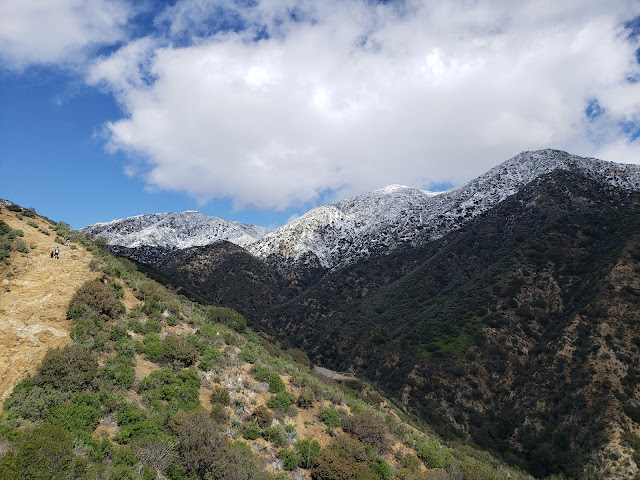
As I rode the 118 east I could see that the entire range encircling the Valley was blanketed white. In the distance, San Gabriel, Markham, Lowe, and Wilson were all covered. I really wasn’t outfitted for snow – shorts, a base-layer, a light mid-layer, and a hiking stick - so I figured it best to avoid these higher elevations where temps were likely to be low and the snow deep. Mission Peak was a possibility but it struck me as somewhat dull. I could see that Los Pinetos and May Peaks both had some coverage so I made my way to Veteran’s Park in Sylmar where I figured I could get to the snow by way of May Canyon Road (3N54).
Someone once told me that the hike out of Veteran’s Park was the North Valley’s equivalent of Runyon Canyon. Other than the absence fit, beautiful people in tight neon garments, I found that to be a fairly accurate description. As I started up the paved fire road, I was joined by throngs of folks making the same pilgrimage that I was making. And most of them looked to be as ill-prepared for the foul weather as me.
The walk up May Canyon Road to the saddle at the crest is a 5 mile road walk on deteriorating asphalt that sees almost 2,000 feet of gain. As hikes go, it isn’t terribly exciting even though the surrounding terrain is quite nice and the view exceptional. Fortunately or unfortunately depending upon your perspective, there is a more direct alternative. Just beyond where the road leaves Veteran’s Park, a steep firebreak follows a ridgeline north all the way to May Peak. Strangely, the vast majority of folks on the trail this day took this more challenging route even though it appeared to be a significant physical struggle for most of them. As I climbed the very steep break, I was joined by dog-walkers, young children in Sketchers, little old abuelas, macho guys in smooth-soled engineer boots, and large, extended families. The most direct and challenging route did not discriminate against hikers on the basis of sex, age, race, ethnicity, sexual preference, fecundity, experience, preparedness, or ability.
A short distance up, the ridge crossed May Canyon Road at a nice vista point. A good portion of the crowd dropped off here. I crossed the road and continued along the ridge route that is comprised of a series of very sharp climbs interrupted by short level sections. As I continued upward, patches of slush began to dot the ground making the path wet and sloppy. That slush then became a thin sheet of snow that covered the ground.
At the base of a steep section of the ridge, I contemplated how much farther I should go. I was in shorts, didn’t have spikes, and really wasn’t prepared for serious winter travel. But from this vantage point, it felt as if I this was the last climb before the route finally topped out. I could see that a few other hearty souls had made their way up before me, so I determined to carry on despite the fact that the slope angle was high and the footing questionable.
At the crest of the climb where things leveled off a bit, I discovered that my figuring was all wrong. Ahead, the firebreak continued up yet another steep climb. And the depth of the snow on the ground had increased to about 10-12.” Going forward would involve plowing through this shin-deep snow in shorts. Going back would require a sketchy descent down a steep, slick slope. Deciding that hypothermia was probably better than serious injury, I continued upward, making sure to step in the virgin snow along the edges instead walking the slippery footsteps of those that came before me.
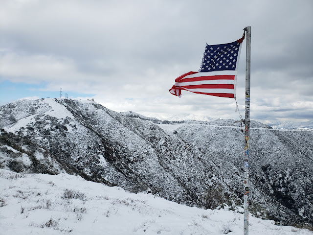
When I reached the top, I finally found myself at the top which was adorned with a shredded American flag fluttering in the icy wind. The pure white landscape was ethereal and surreal and aesthetic. I sat down briefly on a bare rock to absorb both the unique scene and the can of beer stowed in my pack, but found sitting idle to be uncomfortably cold. So I threw on the only additional warmth I had and picked my way through the knee-deep snow and driving wind to the May Canyon Saddle where 3N54 tops out and intersects with Santa Clara Road (3N17.0).
I again momentarily thought about stopping at the saddle for a snack and a drink, but by this point, my feet were wet and my fingers numb. I needed to get off the breezy ridgeline and gain warmth by losing some elevation. Since returning the way I came wasn’t a realistic option given my state of ill-preparedness, that left a 5 mile walk down slushy May Canyon Road.
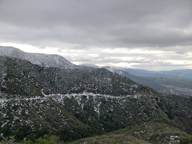
Somewhat surprisingly, the snow clung to the ground quite tenaciously as I descended. I found that escaping it, even on this south-facing slope, took longer than I expected. It wasn’t until I reached roughly the 3,000’ contour that the road was finally snow-free and things began to warm up some. At that stage, I pulled the can of Sierra Nevada Celebration Ale that I had brought out of my pack and walked along with my open container predictably provoking the side-eye from a number of people that I passed.
After what seemed an interminable amount of time, I was back at the vista point where the ridge route first crosses the road. Here, I retraced my steps down the steep fire break to Veteran’s Park. As is typically the case, the descent on tired legs and old knees was much more difficult than the climb up. That reality reinforced for me that the decision I had made earlier in the day to continue up the ridge when I first encountered snow was the correct one.
Anyway, it was a rare and beautiful snow day in Los Angeles. Regardless of how you choose to describe the climate and ecosystem here, the snow this season has brought us is anything but ordinary for this glitzy, mid-latitude metropolis that folks are fond of calling a desert.


