Showing posts with label Sespe Wilderness. Show all posts

Monday, November 23, 2020

Ain't No Cure for the Pandemic Blues

Muau Flat Thorn Point
Thorn Point and Mutau Flats

Sometimes I wonder what I'm gonna do
But there ain't no cure for the summertime blues
~Summertime Blues, Eddie Cochran

So I'll meet you at the bottom if there really is one
They always told me when you hit it you'll know it
But I've been falling so long it's like gravity's gone and I'm just floating
~Gravity's Gone, Drive By Truckers

As you can tell from looking at the large gap between posts here, I haven't been inspired to write much lately. The process has always been a laborious challenge for me, but now it's a real struggle to even put pen to paper. Being the opinionated bastard that I am, it's not that I don't have anything to say. Just ask the people around me. They know that I'm rarely at a loss for words. And they're probably grateful for the respite from my constant yammering and bloviating. But the whole thing weighs on me. The muse has abandoned me without notice and everything I try to write now feels forced and inauthentic.

But these are strange and frightening times we're living through. People are fucking dropping dead from an enemy that can't be seen or fought. We're all wearing face-masks at the grocery store for fear of contagion. I haven't shaken a stranger's hand or given someone outside of my bubble a hug in months. I'm maxed out on vacation accrual, but can't go anywhere to use it. The restaurants and malls are empty, but the trails are packed with people, graffiti, and trash. And politicians' promises notwithstanding, it don't look too much like things are going to get materially better for the average person any time soon. So yeah, things are kind of fucked up right now. For that reason, I guess my muse can be forgiven for perhaps having a case of the pandemic blues.

In an effort to get out of my funk, I decided a day in the woods would be good for my soul. So last Friday, I played hooky from work and headed for San Rafael Peak, a seldom-visited summit deep in the Sespe Wilderness. 

The Iron Hiker joined me on this adventure. The original plan, devised by the ferrous one, was to hike Hines Peak and Cream Puff from the eastern terminus of the Nordhoff Ridge fire road. To do that, we needed a permit from the Forest Service. But that plan was foiled when fires closed the entire Los Padres for a spell and permits became unavailable. Then, the normal, seasonal closure of the Nordhoff Ridge road went into effect guaranteeing that we would not be doing Hines Peak the easy way until next spring. So we went searching for a remote, uncrowded, and challenging alternative. San Rafael checked all of those boxes nicely. 

Grade Valley Road
Morning Commute

Cattle Drive

We met early at the entrance to Grade Valley Road and then drove the 10+ miles south on a washboard dirt road to the Johnston Ridge Trailhead. Sunlight peaked through the forest canopy as we went and I kept an eye out for wildlife as the conditions seemed ripe for a sighting or two. Unfortunately, all we encountered was a herd of bovine blocking the road that weren't in any particular hurry to cede ground to us. But being the superior beings that we are, we dispatched the dumb beasts with a couple of blares of the horn and we were on our way. 

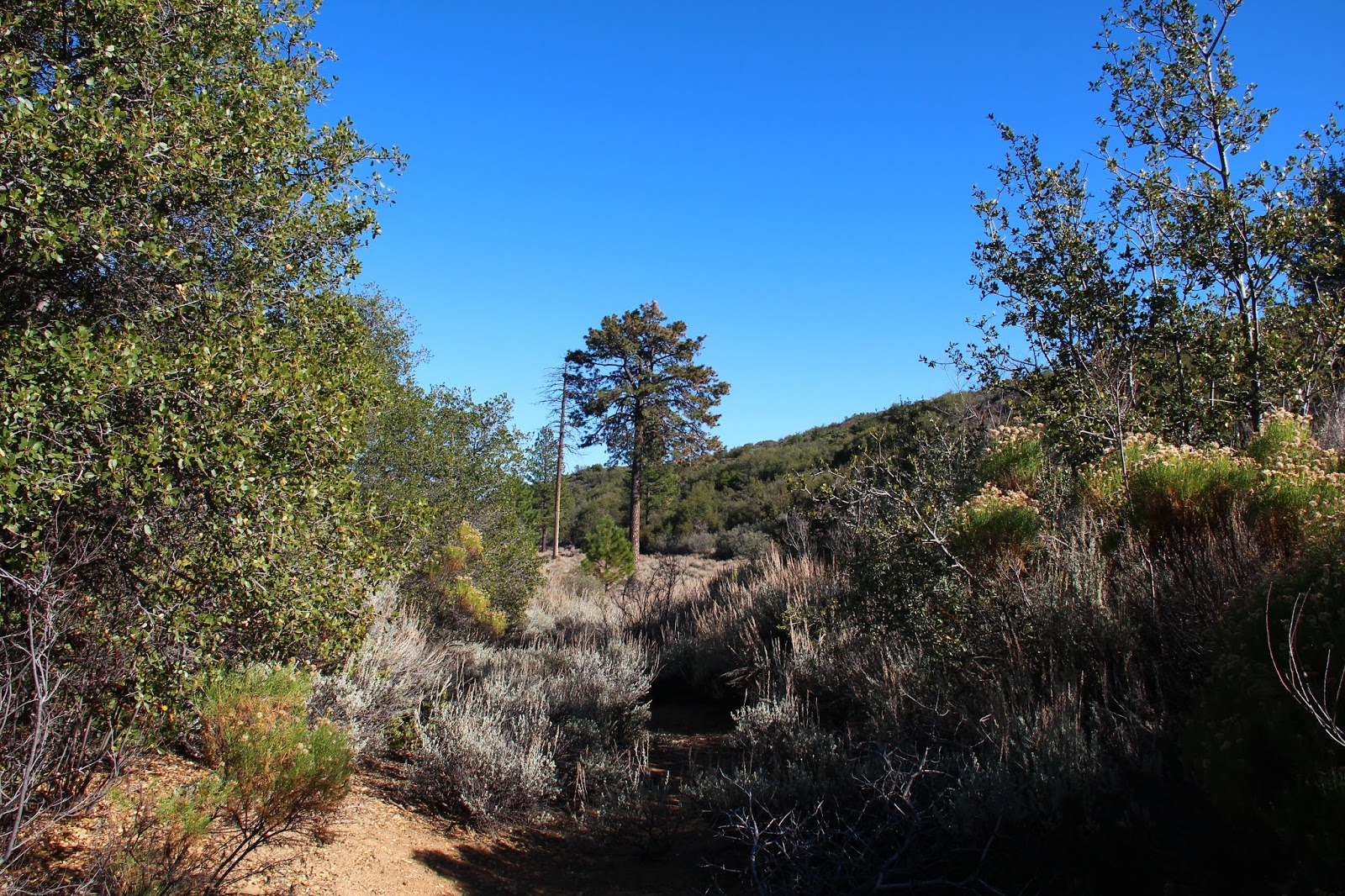
The trailhead parking area was vacant. We were the only ones in the forest. We gathered our gear and started off, heading southeast on a well established trail that skirts Mutau Flats to the south as it drops about 200' in elevation to Mutau Creek. The word "Mutau" features prominently in this part of the forest. Although linguistically it sounds like it could be Chumash in derivation, it's actually the last name of a cantankerous old horse rustler who homesteaded these parts. Old Man Mutau, who settled in the area that is now the flats, was a known ally to horse thieves who moved stolen horses along the Horse Thief Trail from southern Ventura County to Kern County. Mutau, whose homestead sat right along the trail, permitted rustlers to use a canyon on his homestead (appropriately named "Horse Thief Canyon") to graze purloined horses before they were moved off to Tehachapi to be sold to work crews who were constructing the railroad from San Francisco to Los Angeles. Old Man Mutau met his maker at the flats that now bear his name when was ultimately shot and killed there.

Little Mutau Creek Trail
No Country for Old Men

Mutau Creek Sespe Wilderness
Mutau Creek

Little Mutau Creek Trail
Breathing Room

Mutau Flat
Moo-tau

Mutau Creek was still flowing some, so we splashed through and started up a minor drainage that climbed to an obvious saddle at 5,729'. Along the way, we found a mylar balloon with a bright pink boa that we would retrieve on our way out. (PSA: stop releasing mylar balloons into the air people!) At the saddle, the trail continues east, dropping into the Little Mutau Creek drainage. Here, however, we abandoned the trail, opting to go cross-county in a southerly direction over a serious of bumps that lead to San Rafael Peak. 

The Sierra Club says that the navigation along this part of the route is "difficult," but we found it to be pretty straight-forward. At one stage, we wandered slightly off-track, going too low on the northeast flank of Pt. 6,408, but we quickly righted ourselves by making a steep climb back to the ridgeline which has expansive views of Hot Springs Canyon and the Sespe Creek drainage. We then traversed one final minor bump and made the steep climb to the summit. 


San Rafael Peak Route
Going Off the Grid

San Rafael Peak Route
Dragon's Back

San Rafael Peak
St. Raphael

Hot Springs Canyon
Home of Hot Springs

Atop San Rafael we had 360-degree views of the entire Ventura County backcountry. Cobblestone, Topa Topa, Devil's Heart, Hines, Chief, Thorn Point, Haddock, Reyes, and Pinos are all clearly visible from summit. We logged our appearance in the summit register which dated back to 1974 and then lollygagged in the warm sun and tried not to share our snacks with a bunch of insistent hornets that magically appeared every time a plastic baggie or foil was opened.  

Then it was time to go. Days are short this time of year and light a precious commodity. We were well equipped with lighting, but really didn't want to have to rely upon it. So we retraced our steps back to the trailhead and began the long drive back to the reality of life in a pandemic. I can't say that this little adventure cured my pandemic blues or broke my writer's block, but as the old saying goes, "sometimes you just need to go off the grid and get your soul right." And my soul was right on this day. 

Cobblestone Mountain
Cobblestone Views

Devil's Heart Peak
Topa Topa and Devil's Heart

Summit Pano

Thorn Point
Thorn Point, Haddock and Reyes

San Rafael Peak Route
Going Back Home

Tuesday, July 11, 2017

David Stillman Speaks


David Stillman is a legendary and prolific explorer of the southern Los Padres National Forest. He is a walking encyclopedia on the forest whose knowledge was gained from raw experiences on, but mostly off the established path. I don't think it much of an exaggeration to say that David Stillman knows more about the southern Los Padres than all but a very select handful of folks.

From 2008 to 2015, David actively maintained a blog (http://davidstillman.blogspot.com) that catalogued his numerous explorations of the forest. Then, in mid-2015 his voice inexplicably fell silent. He posted no more. As Jack Elliott appropriately observed, "And like that, poof, he's gone. Underground. Nobody has ever seen him since. He becomes a myth."

Well I chased the myth down to find out what he is up to these days. As always, David was very accommodating of his time, free with his information, and tolerant of some of my dumb questions. Here's what David had to say:

Wildsouthland (WS): First off, how are you David? Are you still healthy, happy, and wise?

David Stillman (DS): Happy? Generally. Healthy? I won’t bore you with the numerous orthopedic insults that afflict me, but I did tear up my achilles in April and that’s had an impact on my abilities. Wise? It’s a work in progress.

WS: Tell me what you’ve been up to for the past 2 years?

DS: I’ve been pretty busy. Death Valley, the Mojave, the southern Sierra, Arizona,
Nevada, and Utah. I’ve been ranging pretty far and I find that a change of scenery is
pretty refreshing.

WS: Are you still climbing peaks, busting brush, and trodding the trails of the SLP?

DS: Um, the short answer is “Not so much.” I recently logged some time in the Miranda Pines/La Brea Canyon part of the San Rafael, and there was a nasty slog off trail somewhere on the south side of Sierra Madre Ridge that got a bit sporty. I guess you could say I still go out and get torn up. But summits, no. I’ve already done the SLP summits that interest me.

WS: Where have you been recently?

DS: The last outing, a couple weeks ago, involved waking up at 03:00, driving to Lake Isabella, hitting up some rock art sites in the Walker Basin and topping the day off with a 12 mile hike in the woods above the Lake. Then driving home. That was a rewarding day.

WS: Let’s get down to what everyone wants to know. For years you published a very informative blog about your adventures in the SLP and beyond. In 2015 you stopped publishing and went on a temporary hiatus which appears to now be permanent. A lot of folks were bummed about that, including me. Can you tell me what prompted you to stop publishing?

DS: I can. It’s complicated, but let me try to reduce my reasoning to something that makes sense. On one hand, I had this blog going, which was becoming popular for a whole range of reasons. It had taken off to the degree that a local mountain rag can. On the other hand, it wasn’t fun anymore. I began to understand that the need to generate new material, to stay popular and relevant, and to one-up myself every time I went out was really not what I wanted to be about anymore. It started reminding me of Caesar; Vini, Vidi, Vici and all that. I just gradually started to feel like the blog, and not my time in the woods, was what was more important. When I finally recognized what these feelings were, I decided it was time for a change.

WS: How much did controversies over access to certain locations and the constant criticism of internet trolls play into your decision?

DS: The B.S. definitely played a role. Along with a growing readership I attracted plenty of people who were watching what I was doing through the eyes of their own agenda. There weren’t many outright trolls, but organizations like the Wind Wolves Preserve, and the US Forest Service were paying pretty close attention to where I went and what lines I crossed. Also, a particularly vocal shade of archaeological academia made it their mission to equate what I was doing vis-a-vis rock art with the vandals out there. The way I saw it, I was going to go see these places whether they liked it or not, and the fact that I never gave out directions or coordinates or posted landscape shots
that others could use to find sacred places wasn’t good enough for them. The way they saw it, anybody not sanctioned by themselves had no business seeing or appreciating these sites.

WS: Do you ever see yourself starting back up again?

DS: That’s the big, bad question again. To this day, every time I go out and come back with great photos and a solid tale I want to post. The bug is still alive, but I also realize that I’d be less active in the Los Padres, and I certainly wouldn’t be out there doing 25 mile peak bagging days. Mostly because I don’t feel I have anything to prove. I’m content that I left a record of achievement in that forest that stands on it’s own.

WS: Even though you’re not presently publishing, the archival content of your blog is still available on-line for folks to access. It’s very helpful information to those of us that like to explore the SLP. What are your plans for your blog? Do you intend to keep it accessible into the future? If not, what is to become of its content?

DS: I intend to maintain the blog as it is today. I basically consider that content to be in the public domain.

WS: Have you ever thought about putting that content together as a book?

DS: An interesting question, but no, I haven’t considered that.

WS: How and when did you first get into exploring the SLP?

DS: My father was a naturalist/biologist out of UCSB. He introduced me to the Los Padres. Mostly by dragging me here and there to see animal poop. Seriously though, I remember hiking into and camping at White Ledge Camp under Topatopa when I was 5. I did Chief Peak when I was 10, with that old sadist Glenn Hackworth. Being in an active Scout troop really set the hook. The first time I hiked Whitney I was 12. I ended up doing big summer road trips with a friend. We’d save all year and take off for the summer, we were 16, 17 years old. We’d hike in Montana, Idaho, Washington, New Mexico. Past that I was heavy into rock climbing and mountaineering. I moved back to the Central Coast in 2000 and resumed hiking in the SLP in 2005.

WS: How did you gain your extensive knowledge about the forest? Did you gain it primarily from books or from raw experience?

DS: I just went. But I will say I have a boner for maps, and I’ve never paid much attention to where the trails are. They’re just lines on the map.

WS:  Who were some of the folks that you looked to, and still look to, for guidance and information about the SLP?

DS: Uh, I just figured this shit out on my own. It wasn’t until later, when the blog became a thing, that I started meeting other SLP people of note.

WS: I don’t know these folks, but guys like Craig Carey, Jack Elliott, Mickey McTigue, Bardley Smith, those are some of the guys I consider giants of SLP knowledge and adventure. Do you know all of those guys? Are they still exploring and writing, or are they “retired” like you?

DS: I know of McTigue, but have never met him. Bardley I’ve met a couple times. He’s a guy I wish I could get to know better. He’s probably got some good stories. Craig is heavily involved in the forest, both through the Scouts and with the USFS. He’s done some really good things and I admire him. Jack Elliott is still a close mate. He and I get out every couple months for something that usually turns out amazing. In a word, Jack is stalwart. And a good mate.

WS: Who, if anyone, do you see taking up the mantle you have laid down? Any young SLP up-and-comers that we should know about? Who are the next generation of SLP prophets?

DS: No idea. I don’t really care what other people are doing. I’m not on social media and I rarely look up anything to do with the Los Padres because I already know everything I personally need to know about it. I know I sound like a dick but I’m just not a social person. I will say that there are always tough people doing awesome things in that forest.

WS: Shifting to your other interests, I know you are interested in native rock art have documented a number of Native American rock art sites. How did you get involved in that?

DS: I guess it was always there. My grandfather had grown up in Santa Barbara and had collected baskets, points, tool and the like. We call that looting nowadays. I visited the Alder Creek site when I was 11. Over the years it just became an ongoing and unrelenting interest. Aboriginal art of any type is interesting to me. I usually plan road trips and hikes around rock art sites. A good rock art panel adds a bit of mystery to any day. Plus, a lot of these places are hard to find so there’s the easter egg factor. Been to hundreds of sites and far from done.

WS: Do you coordinate your outings and share information behind the scenes with scientists and archaeologists, or is it primarily just to satisfy personal interest?

DS: Absolutely not. Next question.

WS: I know there has been some blow-back by folks about you publishing images of some of these sites, even though you have never disclosed the locations. Their protectionist attitudes are understandable given the damage that occurs at publicly know sites like Piedra Blanca for example. How do you reconcile the need to protect these sacred sites with the desire to document them and share them with the world before they disappear?

DS: I’ll start by saying that the protectionism around the local stuff, Chumash art, is unlike anywhere else. By protectionism I mean mostly academia. Other regions are comparatively much more relaxed about access to rock art, and yeah, there’s always some jackass out there that’s going to defile a rock art site, but the venom coming out of certain corners when one poaches their patch is pretty remarkable. This is the only region I’ve visited where certain constituencies actively discourage the visitation of rock art sites, and fight hard to assert their own right to those sites at the expense of the
few interested public.

WS: Have you had conversations about this with Native American tribes and how do they feel about it?

DS: I have nothing to talk about with the Chumash. It probably wouldn't serve anyone’s interest to share where I’ve been or where I’m going.

WS: Ok, this is kind of a “secret sauce” question. But if you could only visit one site in the SLP before you die, where would you go and why?

DS: Of course I’ve already been there. There was always some hidden gem and impossible mission in the SLP. But I ran out. For the purest, most unique experience in this forest I would have to hand that to Hole-in-the-Wall. Of course it is deep in Condor Preserve country and I can’t endorse going there. And good fucking luck if you try.

WS: What’s next for David Stillman? I know you’re hoping for a trip to Denali. But what else do you have in the hopper?

DS: Let’s see. Italy in the Fall. I still have the three most minor California fourteeners left to do. I’ve got a couple adventure motorcycles now and I’m finding that travel on a tricked out enduro suits me. I can really experience getting into rugged, out of the way places. Camping off a bike is pretty special. And getting into the back deserts and dark mountains alone on a bike is right up my alley. One day, the Yukon to Denali.

WS: What was your hardest day in the LP?

DS: No doubt about it, Devil’s Heart Peak. 22 hours, going into and out of, up and down the Sespe, plus a peak nobody’d ever climbed. Yeah, toughest day.

WS: What was your most rewarding day in the LP?

DS: Easy answer, White Ledge Peak. There was insane route planning, insane trespassing, a mountain lion, an unclimbed gully to a massive face overlooking the ocean, and a new route to a summit nobody’d had in a generation. 

WS: What was your worst day in the LP?

DS: I've never had a truly bad in the the LP. Knock on wood.

# # #

Thursday, June 29, 2017

A Man Could Lose His Way in a Country Like This

San Guillermo Peak
A man can lose his past in a country like this
Wandering aimless
Parched and nameless
A man could lose his way in a country like this
Canyons and cactus
Endless and trackless
~Rush, Seven Cities of Gold

I spend a considerable amount of time virtually exploring places I’ve never been by pouring over images on Google Earth and searching topographic maps on CalTopo. For better or worse, I’ve passed this idiosyncratic trait onto my eldest daughter who now carries on the tradition. Most of these “out of body” explorations involve the wild places close to home, the Los Padres National Forest and the Angeles National Forest, but I frequently stray beyond these boundaries to the San Bernardino National Forest, the Sierra Nevada, and to other far-away places I’ll probably never go other than in my fervent imagination.

Recently, while staring at the computer screen and time-traveling across the magnificent canyons and ridgelines that texture the southern flanks of Mt. Pinos, I noticed a narrow slot in the lower sections of the Middle Fork of Lockwood Creek that piqued my interest. Some online searching unearthed a short YouTube video clip posted several years back by a guy who had visited this area which he described as “the narrows of the Middle Fork of Lockwood Creek.” Additional scouring of the interwebs revealed nothing about this little canyon.

So this past weekend, my daughter and I drove to the Lockwood Valley in hopes of getting into the narrows. Much of this area is a crazy-quilt of public and private land that is crisscrossed by a network of mostly dirt roads. One or more of these roads, I surmised, would allow us easy access to the Middle Fork of Lockwood Creek which we would then ascend to the narrows. 

Along Boy Scout Camp Road, we swung off the pavement and tracked north on a gravel road adjacent to the Middle Fork. A short distance later, we encountered private property and a chain blocking our forward progress. Back-tracking to Boy Scout Camp Road, we tried a different dirt road on the other side of the Middle Fork. But to call this track a road is being generous with the term. It was narrow and soft, and the encroaching sagebrush scraped the side of the car as we proceeded forward. Ultimately, this option failed us too.

The preordained back-up plan was Mt. Pinos. But as we headed back to Lockwood Valley Road, San Guillermo Mountain and dark storm clouds loomed nearby to the south. So that of course became our new objective.

We found Pine Springs Campground mostly deserted except for a few hardy souls that were toughing it out in the oppressive midday heat. A couple of small RVs occupied the lower spaces. A tent and assorted gear filled the upper-most site in the loop. A woman peered at us over her bikini top as we circled the campground, a plume of dust trailing us. Looking at this moisture-deprived place, it's easy to forget the big winter we just had.

The air was still and the heat withering as we dropped into the dry drainage adjacent to the campground. On our way, we passed a plastic bucket topped with a section of pool noodle. Toilet paper was strewn hither and yon, while a shovel lay nearby at the ready. A make-shift privy, necessary I suppose since the outhouses at Pine Spring were boarded up tight for some odd reason.

In the drainage, we boulder-hopped west for a short distance, following cairns and the occasional piece of brightly-colored tape hanging limply from encroaching tree limbs. Little black flies buzzed us incessantly. A short distance later, we left the creek bed for a low ridge that splits San Guillermo from Pt. 6,324 to the immediate south. Here, the flies disappeared, chased off by occasional wind gusts heralding the imminent arrival of high-country thunder-showers. Ominous dark clouds hung leaden in the sky, neither advancing toward nor retreating from us. We stopped, looked skyward, and checked wind direction, contemplating the possibility of being caught on an exposed ridgeline during an electrical storm. But sometimes storm clouds are like bullies, threatening but ultimately pulling their punches. And so it was with these clouds. We faced the threat and pressed forward while the storm retreated to the northeast.

Atop the ridge leading to San Guillermo, the impressive expanse of the Sespe Wilderness unfolded before us. The trackless sweep of Wagon Park Canyon spread west to the horizon. To the south lay the boundless headwaters of the Piru Creek drainage. Eastward sat Mutau Flat and the big empty. Mt. Pinos and the beginnings of the Cuyama Badlands buffered the north. This is vast and vacant terrain that doesn’t give up its history or its secrets easily. A man could lose his way in a country like this.

Ultimately, we didn’t go deep enough or long enough to lose our way. We were ill-equipped for that type of undertaking. But the prospect and promise of that very sort of adventure exits in a place this unspoiled, this magical. It’s a compelling proposition, isn’t it? To have a grand adventure. To walk into the wilds and back in time. To get completely lost, if only within one's self. To experience the raw fear and magic that only the remote backcountry is capable of manufacturing. The certainty of all of that is just too tantalizing to pass on. We will return. To secure the missed reward. To collect on the promise.


Sunday, November 20, 2016

Ambling Along the Dry Lakes Ridge

The First Dry Lake Along Dry Lake Ridge
You will follow me and we will ride to glory, way up, the middle of the air!
And I'll call down thunder and speak the same and my work fills the sky with flame
And might and glory gonna be my name and men gonna light my way.

Just out of Ojai and beyond the point where the Maricopa Highway squeezes through the slot of Wheeler Gorge, a high mountainous barrier towers above the roadway to the north. The unmistakable geologic feature with an east-west orientation is so impenetrable that the road-builders were to forced snake around it when the road (originally designated Highway 399, but now Highway 33) was surveyed and constructed in the early part of the last century. This imposing obstacle is Dry Lakes Ridge.

In my many forays into the Ventura County back-country, I've admired this ridge with wonder and awe. Based upon the many good trip reports published by my fellow wilderness travelers, I knew the ridge was comprised of a series of dry lakes or basins, and that the area atop the ridge was designated as a botanical area because of the unique flora that it harbors, but never having experienced it myself, I was left to imagine what it was like to travel along its spine.

Well, I now have to imagine no more. Last week, a friend and I decided to tackle the ridge in order to get a first hand look. Given its configuration, and depending upon your definition of the term, there really is no "easy" way to gain the ridge. There are only gradations of steepness. Stated differently, from a topographic perspective, the spread between the contour lines for the ridge range from almost non-existent in some areas to merely close together in other areas. Despite this, there is an obvious and traveled route to the top which involves ascending an old fire-break that runs down the eastern tongue of the ridge to intersect Highway 33 where it tops out near the Heliport benchmark at elevation 3736.

From the highway to the top of the ridge, the way forward is fairly obvious although there is no established trail. The initial climb is stout but it mellows some once you attain the ridge. There, you get nice looks at the Pine Mountain Ridge, the upper Sespe drainage, the Nordhoff ridge, Lake Casitas, and the coast. The track then continue upward, wending it's way through the ubiquitous manzanita to the high point and your first glimpse of the eastern-most dry lake.

The Pine Mountain Ridge

Piedra Blanca and the Upper Sespe Drainage
Zoom of Pine Mountain Ridge

The Abandoned Fire Lookout on Nordhoff Peak

Nordhoff Ridge, Lake Casitas, and the Channel Islands

Toward the Coast
Dropping into the first basin, the "correct" way to go became a bit muddled as various tracks zigzag through the manzanita, buckthorn, wild rose, yucca, and an assortment of other spiky flora that like to jab and grab. We veered left, aiming for an open spot in the sea of brush and what appeared to be "the path." As it turns out, this route terminated in a clump trees which we fought through, ending up in the first dry lake bed itself. We then did battle with the plentiful sage that populates the basin until we picked up the faint use path again on the western edge of the lake. Note to self: go right time.

Once we got back on track, we wandered through the second and third basins which are very similar in character to the first. Beyond the third lake, the path squeezed through some trees before cresting a small hill and revealing the big, open, grassy basin of the fourth lake below. We enthusiastically dropped into the lake bed aiming for the big evergreens in the middle. Here we found shade, a fallen log on which to enjoy lunch, and an old ice can stove, a remnant of a bygone trail camp. This is a really neat spot and we lingered here enjoying the solitude and the sound of the wind rustling through the grass.

Yellow - yes; Red - no

In the First Dry Lake
Looking Back Toward the Third Lake

The Fourth Dry Lake

In the Grassy Bed of the Fourth Lake

Looking Back at the "Trail" Into the Fourth Lake

Sitting in the Shade

Vestiges of the Old Trail Camp
Just beyond and west of the fourth lake, sits the tiny fifth lake. Had I spent more time studying my maps, I would have known this. But I didn't so I didn't. So instead of visiting this last dry lake while we were in the neighborhood, we instead turned tail here and retraced our steps back to Highway 33. Recognizing the error and stupidity of my ways back in the car, we headed for Institution Ale Company in Camarillo where I drowned my sorrows in a pint of Citra pale ale and planned a return to the ridge to pick up that last dry lake.  

Citra Pale Ale at Institution Ale Company. Go Here for the Best Beer Anywhere.

Thursday, October 6, 2016

Dough Flat Walkabout

The Striated Bluffs of Whiteacre Peak
Many years ago, when I first came to Ventura County and before I got my Los Padres "forest legs," I made the long drive out of Fillmore up Squaw Flat Road (6N16) to see Dough Flat. I don't really know what compelled me back then since Dough Flat is generally not touted as much of a scenic destination, but I had noticed 6N16 stabbing deep into the Los Padres National Forest from the south on maps and I was intrigued by the relative isolation of the spot. So I made the drive just to satisfy my curiosity. When I arrived, a couple of rag-tag characters were loitering about the small gravel parking area. They stared me down as I rolled through like I had interrupted some nefarious activity, so I just kept moving. At least that is how I remember it now. In truth, they were probably just a couple of dirty backpackers who were surprised to see someone else make the trek to Dough Flat. Regardless, I stayed away for a couple of decades as the place just didn't spark my imagination or feel that inviting.

Last weekend I decided to return to the scene of the original crime. Half of the adventure in going to Dough Flat is getting there. Squaw Flat Road, which begins in Fillmore as Goodenough Road, is initially paved. As the road wends its way north and gains elevation, that pavement deteriorates eventually turning into gravel. The lower section of the road, which is routinely used to access the numerous oil leases that dot the area, is fairly well maintained. Past the last oil lease about 1/2 mile before roads end however, the track steepens a bit and becomes considerably more rocky. It's all negotiable without 4-wheel drive, but the going is slow.

View Across the Sespe Creek Drainage and Into the Condor Sanctuary
Bluffs Along the Whiteacre Ridgeline
When I arrived at Dough Flat this time I found the parking area completely empty. A sense of isolation came over me as I pulled on my boots and began up the Alder Creek Trail. Before I even reached the wilderness boundary, I encountered huge piles of scat on the path which I would continue to see throughout the day. This is undoubtedly bear country although it really doesn't look like it. I always imagine bears in lush green forests ribbonned with flowing water and festooned with lakes. This is definitely not that. It is an arid and inhospitable place of rust and tan and prickly plants.

I didn't really have an agenda for the day other doing a bit of exploring. I first wandered up to Squaw Flat and kicked around at a guerrilla camp I found there located in a clump of trees. After that, I continued up the gently rising path to the split with the trail out to Ant Camp and scouted routes up Pts. 4082 and 4706. The left fork of the trail took me out to Cow Spring Camp where I lunched at the fairly unattractive trail camp and searched without success for the spring after which the place is named. Water is so yesterday in this parched landscaped of the new millennium. I did, however, locate a Forest Service benchmark (EM 22) trailside around Stone Corral next to a rock formation I dubbed the Backcountry Throne.

Trailhead Signage en Espanol. The English language version is vandalized.
Entering the Sespe Wilderness
Whiteacre Peak from the Alder Creek Trail
Squaw Creek Drainage
Point 4082 from Squaw Flat

View South toward Dough Flat
Point 4082 (left) and 4706 (right)
Doubling back to the trail split, I followed the track out toward Bucksnort Spring to see if I could find water there. A trail guide I have from the late 1980s said that the spring was "fouled and useless." But that guide was written in an era when cattle and mountain bikes had free reign of the land. Now it is wilderness and a condor sanctuary.

Over a small rise and up a drainage, I spied a knot of green that looked out of place in the sea of brown. This was clearly Bucksnort Spring. I followed an obvious use trail up to where the spring is supposed to be where I found another guerrilla campsite, but no surface water. The greenery was no mere happenstance, however. There is water here, but it must all be subterranean at this stage.

On the way back to the parking area I scouted Sulphur and Whiteacre Peaks. Both are in the Condor Sanctuary and technically off limits, but I know they have both been scaled by intrepid adventurers who shall remain nameless. Suffice it to say that of the two, Whiteacre is the easier to access. Anecdotally, Sulphur, which is further away, has to be attacked from the Tar Creek side since any approach from the Pigeon Flat area is reputed to be chocked with brush. But the forest service has been forced to close Tar Creek because people don't know how to behave in the backcountry. So until that changes, Sulphur Peak seems to me a very difficult proposition.

View North to the Sespe Backcountry
Cow Spring Trail Camp

Forest Service Benchmark EM 22

The Backcountry Throne
Back at the parking area I found myself still completely alone. Not really surprising given the effort required to get to Dough Flat and the lack of an immediate "wow" or payoff, that many forest visitors are looking for and expect. Of course, I was completely content with the solitude. I pulled out my chair, removed my boots, cracked a cold beer, and listened to the light breeze rustling through the scrub and the faint but perceptible hum of the land.

Blue Sky
Cow Spring Area from Stone Corral
Native Flora