Showing posts with label Los Padres. Show all posts

Sunday, May 30, 2021

Los Padres Double Delight


Hines Peak and Creampuff

The true delight is in the finding out rather than in the knowing.
~Isaac Asimov

Suck it up, cream puff!
~Captain Lee

I've spent a good amount of time over the past couple of decades exploring the backcountry of the southern Los Padres. I've also sat in my living room attentively pouring over maps of the Sespe, staring at peaks and trails and rivers and canyons and ridgelines and fantasizing about what it would be like to experience those abstract places that exist only on a Tom Harrison map and in my fertile imagination. Because of this, I've known for some time about Hines Peak and it's slightly shorter neighbor, Creampuff. I had just never actually been to either of them. This dereliction of exploratory duty certainly wasn't due to my disinterestedness. Instead, it was primarily the result of the challenge of actually getting to these two peaks which sit in a rather difficult-to-access corner of forest. The only two ways to reach these peaks is either by a very long and tortuous walk or, a long and tortuous drive along the Nordhoff Ridge Road to Elder Camp near the road's junction with the Red Reef Trail (permit and 4-wheel drive required).  

But as Isaac Asimov said, true delight isn't in the knowing. It's in the finding out. So when Keith (aka, the Iron Hiker) suggested that we drive to the end of the Nordhoff Ridge Road in his 4x4 Tacoma, and then scale both Hines and Creampuff, I jumped at the opportunity. Time to be delighted. 

Rose Valley and the Nordhoff Ridge Road

We met at Rose Valley early. Sean (aka Cucamonga Man) and Cecelia joined us there and we all piled into Keith's truck. As we began the long drive up 5N42, the marine layer hung thick and low in the air, blanketing the hillsides with an ethereal mist and obscuring the path forward. At one stage, the cloud-cover became so dense that I had to get out of the truck in order to tell Keith where the road was.

After a slow, bumpy, and foggy drive, we found a place to park just beyond Elder Camp and began our hike. At road's end, where the fire road intersects with the Red Reef Trail coming up from White Ledge, a couple was camped on a broad flat with magnificent views into upper Lion Canyon and the Sespe. Here, the mist finally began to burn-off as we climbed into the Thomas Fire burn zone which scorched this area in 2017. A Poodle Dog orgy was in full swing here, so we had to bob and weave and dance our way around the offending bush until it petered out near the saddle that separates Lion Canyon to the north and Santa Paula Canyon to the south. Here, we caught our first glimpse of the day's objectives piercing the pillowy cloud bank.

Red Reef Trail
How it began

Lion Canyon
Upper Lion Canyon

Red Reef Trail
Trudging Along the Backside of the Topatopa Bluffs

Cucamonga Man
The Cucamonga Man in his Natural Environment

Creampuff
Creampuff (foreground) and Hines (rearground) from the Saddle

After we "ooh'd" and "ahh'd" for a spell at the grandeur of the scene before us, it was an easy stroll to the base of Creampuff. We stopped briefly to survey the steep route we would later be taking up Creampuff's north face, and then continued down the trail to climb Hines first. Dinner before sweets. 

The Climb to Hines Peak

The route up Hines begins at the shallow saddle between Hines and Pt. 6,403. The Red Reef Trail continues in a south-easterly direction dropping down to Ladybug trail camp and then continuing all the way to the Sespe where it intersects the creek near Oak Flat. Recent reports indicate that this trail is passable from Oak Flat to roughly the old Horsethief site. But between there and Ladybug, the path is apparently a tangle of overgrown brush that is difficult to follow. No bueno.


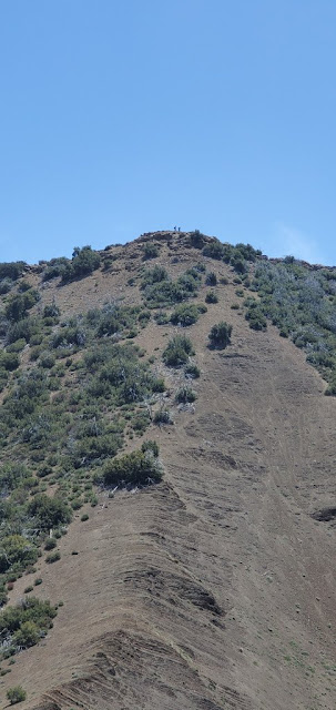
After gulping some water and a Shot Blok for a quick energy jolt, we began the slog upward. There is no formal path, but there is a visible use trail worn by others who came before. We tracked this use trail as closely as possible, but as these things typically go, it eventually frayed into a number of strands the higher we went, so each of us just picked our own way up. The north side of Hines is basically comprised of loose dirt over bedrock so it was steep and loose going. After scampering up a sketchy chimney which was the crux of the climb, we topped out on a false summit. A short distance later, we were on the actual summit where we found a register and two benchmarks, but limited views. Celebratory pictures were taken, obligatory entries were entered in the registered, and then we retraced our path back to the saddle. The retreat from the top was a quick and dirty affair, much easier than the climb.  

The Sespe
Sespe Views

Hines Peak
Creampuff (right) and Hines (left)

Creampuff Peak Route
The Spine Route to Creampuff

Hines Peak
Hines Awating Us

Hines Peak
The Route Up Hines

Hines Peak
The Cat Walk - Don't Slip Here

Climbing Hines Peak
Keith Attacking Hines

Ladybug Camp Sespe Wilderness
Looking Toward Ladybug and Beyond

Creampuff Peak
Creampuff from High on Hines

Hines Peak Summit Register
Hines Summit Register and Benchmark

Summit Pose - Iron Hiker, WildSouthland, and Cecelia

Hines Peak Route
Dropping Down from Hines

The Route up Creampuff

Cucamonga Man and Cecelia weren't feeling Creampuff, so Keith and I hurried ahead to tackle our second peak. Along the way, we passed the old Last Chance Trail which is mostly abandoned, but can still be seen coming up from Santa Paula Canyon. The route up Creampuff is very similar to the route up Hines, but steeper and looser. Much of the time, the process was two steps forward, one step back as the ground moved continuously beneath our feet. Fortunately, it's a shorter climb - a mere 400' in elevation gain -  and before long, we were atop the summit where we found a summit register and the lid of a cream puff container to mark the spot. Trolling through the register of this "Seldom Visited Site" we recognized a number of entries from Los Padres regulars, including Christopher Lord (Lost in the Los Padres) and Reece McCalister aka Red Tail aka Mupu Mac aka the Lost Padres Lost Boy. This is a superior summit to Hines in terms of views. From this 6,486' aerie, you get panoramic looks at Hines, the Topatopoa Bluffs, and all points south.


Creampuff Peak Route
Ascending Creampuff

Hines Peak
Hines from the Summit of Creampuff

Creampuff Summit Register
Summit Register - a "Seldom Visited Site"

Proof WildSouthland was There

Creampuff Peak Summit
Iron Hiker and WildSouthland on the Summit

How Creampuff Got it's Name

It is worth noting that the appellation "Creampuff" is not the actual, recognized name of this peak. In fact, I don't believe that it actually has a formal name. Which got us to thinking: how did this peak become colloquially known as "Creampuff?" David Stillman pondered this very same question and surmised that two guys christened it "Creampuff" after scaling it with a bag of weed and a container of Costco cream puffs. When I put the question to Bardley Smith, Los Padres legend and sawyer extraordinaire, he told me: "I thought it might be a case of Occam's razor. This was verified by legendary hiker Kim. C. As you found, the register is contained in a 'cream puffs' container." So there you have it. Mystery solved.

Back at the saddle between Lion and Santa Paula Canyon, I realized that I neglected to drink the summit beer I had brought along for the occasion. So I dug that out of my pack while the rest of the crew drank more healthy, but less enjoyable hydration alternatives. Then we all trudged back to the trailhead through the Poodle Dog minefield and the dense fog to end a truly delightful the day in the backcountry.

Friday, March 12, 2021

Tempted by El Diablo's Potrero

The Pothole and Devil's Potrero

I can resist anything except temptation.
 ~Oscar Wilde, Lady Windemere's Fan

I generally avoid temptation unless I can't resist it.
~Mae West 

I've stared numerous times at my Tom Harrison map of the Sespe Wilderness and wondered about the Pothole Trail leading out to the Pothole, the Devil's Gateway, and the Agua Blanca drainage. That area of the Los Padres has been an intriguing blank space on my experience map for awhile now, not from lack of interest, but instead from the difficulty of accessing the trailhead. Ok, perhaps "difficulty" is the wrong descriptor here because accessing the trailhead really isn't that difficult. It's more of a significant annoyance that I have simply refused to subject myself to. That annoyance involves paying $14 to enter the Lake Piru Recreation Area, parking in the visitor's lot, and then making a 4.5 mile road-walk just to get to the trailhead so you can begin the hike. Um, thanks no. A visit to the proctologist holds significantly more interest for me than a tedious 4+ mile, one-way asphalt walk. 

Then, the other day I heard something on my local public radio station that piqued my interest. It was a story about a new parking area and trailhead for the Pothole Trail that was scheduled for opening this past weekend. The improvements are part of the recently-approved Central Coast Preservation Act that designates the 400+ mile Condor Trail as a National Recreation Trial. With the opening of this new trailhead parking area, gone are both the ridiculous entrance fee to the Lake Piru Recreation Area and the interminable road walk. Suddenly, the temptation to visit El Diablo's corner of the Los Padres was more than I could be expected to resist. So I went.

At the kiosk to the entrance to Lake Piru, I told the attendant I was going to the Pothole Trail. He gave me a special permit to hang from my rearview mirror and waived me through without dinging my wallet. Then it was a 5 mile drive on a winding, narrow, and poorly maintained yet paved road to the sparkling new parking area which is equipped with clean restrooms (for now), trash receptacles, and a temporary hand-washing station. But access to the trail itself from here is not immediately intuitive. You don't proceed west from the back of the parking area to begin this hike. Ask me how I know that. Instead, to get to the actual trail, you need to backtrack out to the road and then continue north 100 or so yards where the trail starts on the left, marked by both a new sign and an old, sun-bleached forest service sign that is obscured from the road by encroaching brush.

Lake Piru
Lake Piru

Trailhead Pothole Trail
New Parking Area

Pothole Trail
Trailhead

Because this trail was hyped on public radio where it was probably heard by all types of listeners, a word about the hike ahead is appropriate here. First, this is not a family-friendly hike or one that is appropriate for the casual hiker. From the trailhead, the climbing starts immediately and doesn't let up for a couple of miles. It is a steep, sustained, and relentless grind until you reach that boundary for the Sespe Wilderness at about the 3,200' contour. After that, it's a 1,000' drop in elevation to the Pothole itself, meaning that you are climbing both ways on this hike for a total of 3,000'+ of gain. Additionally, this is a seldom-visited and remote part of the Los Padres. If you go, make certain you are well-provisioned and know how to take care of yourself. If you get into trouble out here, ain't no one coming to assist you quickly. Finally, the initial climb to the wilderness boundary is exposed, south-facing, and shadeless. There is no water until you reach the Agua Blanca. Combine that with the fact that it gets hotter than Hades in this part of the forest, and this is probably not the best choice for a mid-to-late summer hike. In fact, barring a pre-dawn start, hiking here in the summer could be downright dangerous. Heat stroke is real y'all.

With those preliminaries out of the way, I started up the trail which initially crosses a dry meadow and then climbs steeply to the adjacent ridge. Here, Blue Point, so named for the bluish-gray rock bands that streak its south face, comes into view. Behind, and to the northeast, Whitaker Peak can also be plainly seen. The trail then continues to climb, sometimes steeply, in a northwesterly direction following the ridgeline up and over Pt. 3,016 just shy of the wilderness boundary. From a trail-building perspective, the current route really doesn't make a lot of sense. But as you climb, you'll see vestiges of the original trail skirting the numerous bumps on the ridgeline over which the current track goes right up and over. These old trail segments are now so overgrown from disuse and lack of maintenance that the more direct ridge route has ironically become the less difficult default.  

The Meadow

Blue Point Pothole Trail
Blue Point (Whitaker Behind)

Original Pothole Trail
Original Trail Route

Pothole Trail Ridge Route
Current Ridge Route

Pothole Trail Ridge Route
Forever Ridgline

Pothole Trail High Point
Pt. 3,016 - Wilderness Boundary Near High Point in Rear

Cobblestone Mountain
Cobblestone and Vicinity

Just beyond Pt. 3,016, the trail enters the Sespe Wilderness which is well marked by signage. Impressive views of distant Cobblestone Mountain and the more remote reaches of the Los Padres backcountry come into focus. Being the wilderness, mechanized travel is prohibited here, but rogue motorcyclists have ignored that ban and damaged the trail considerably. Typical fucking entitlement mentality. 

From the wilderness boundary (approximately 3,200'), it is a 1,000 foot drop to the Devils Potrero which you finally catch a glimpse of as you cross a narrow saddle at about the 2,800' contour. The trail then passes by Pt. 2,716 to the north, snakes back on itself, and finally deposits you into the potrero adjacent to the the Pothole which was formed by a gigantic slide that has covered the canyon floor with sand and silt. In his excellent blog Songs of the Wilderness, James Wapotich has posted images from the mid-1990s showing the Pothole filled with water and forming a lake reputed to be 15 feet deep. 

Sespe Wilderness
Entrance to the Sespe Wilderness

Devil's Potrero
First View of Devils Potrero

Sespe Wilderness
Saddle View Looking East

Unfortunately for me, I didn't get the opportunity to do anything more than look at the Pothole from afar. Due to a later start than originally intended, I gave myself a 2:30 p.m. hard stop. And by that deadline, I was just shy of the objective. I contemplated pushing on to achieve the objective, but I was solo, it was a fair distance back to the trailhead, and I didn't want to get caught too far out in the fading light even though I was prepared to contend with that type of situation. So I reluctantly turned tail and started the climb back out.

On they way down, I stopped for a couple of minutes on a protruding rock to have a snack, swill a warm beer that I had stowed in my pack, and take in the scenery I had missed on the way up. Because it was now so late in the afternoon, I had the run of the place and I sat luxuriating in the absolute silence, contemplating my return.  

Near the road, I ran into a couple just starting up. They asked me how far it was to the "look-out point." I told them that depended on what they meant by that term, but that they had a long, arduous climb ahead of them before they topped out near the wilderness boundary. Ten minutes later, as I was loading gear into my car, the couple came strolling back into the parking lot. Shortly after our encounter, they apparently realized the folly of attempting to complete the hike with such a late start. So like me, they resisted temptation to continue on, and returned to the parking lot so that they could come back on another day to give the devil his due.

Piru Creek
Ridge View South into the Piru Creek Drainage

Pothole Trail
Roller Coaster Ridge Return Route

Blue Point Piru Creek
Piru Creek and Blue Point

Lake Piru Deer
Piru Locals

Monday, November 23, 2020

Ain't No Cure for the Pandemic Blues

Muau Flat Thorn Point
Thorn Point and Mutau Flats

Sometimes I wonder what I'm gonna do
But there ain't no cure for the summertime blues
~Summertime Blues, Eddie Cochran

So I'll meet you at the bottom if there really is one
They always told me when you hit it you'll know it
But I've been falling so long it's like gravity's gone and I'm just floating
~Gravity's Gone, Drive By Truckers

As you can tell from looking at the large gap between posts here, I haven't been inspired to write much lately. The process has always been a laborious challenge for me, but now it's a real struggle to even put pen to paper. Being the opinionated bastard that I am, it's not that I don't have anything to say. Just ask the people around me. They know that I'm rarely at a loss for words. And they're probably grateful for the respite from my constant yammering and bloviating. But the whole thing weighs on me. The muse has abandoned me without notice and everything I try to write now feels forced and inauthentic.

But these are strange and frightening times we're living through. People are fucking dropping dead from an enemy that can't be seen or fought. We're all wearing face-masks at the grocery store for fear of contagion. I haven't shaken a stranger's hand or given someone outside of my bubble a hug in months. I'm maxed out on vacation accrual, but can't go anywhere to use it. The restaurants and malls are empty, but the trails are packed with people, graffiti, and trash. And politicians' promises notwithstanding, it don't look too much like things are going to get materially better for the average person any time soon. So yeah, things are kind of fucked up right now. For that reason, I guess my muse can be forgiven for perhaps having a case of the pandemic blues.

In an effort to get out of my funk, I decided a day in the woods would be good for my soul. So last Friday, I played hooky from work and headed for San Rafael Peak, a seldom-visited summit deep in the Sespe Wilderness. 

The Iron Hiker joined me on this adventure. The original plan, devised by the ferrous one, was to hike Hines Peak and Cream Puff from the eastern terminus of the Nordhoff Ridge fire road. To do that, we needed a permit from the Forest Service. But that plan was foiled when fires closed the entire Los Padres for a spell and permits became unavailable. Then, the normal, seasonal closure of the Nordhoff Ridge road went into effect guaranteeing that we would not be doing Hines Peak the easy way until next spring. So we went searching for a remote, uncrowded, and challenging alternative. San Rafael checked all of those boxes nicely. 

Grade Valley Road
Morning Commute

Cattle Drive

We met early at the entrance to Grade Valley Road and then drove the 10+ miles south on a washboard dirt road to the Johnston Ridge Trailhead. Sunlight peaked through the forest canopy as we went and I kept an eye out for wildlife as the conditions seemed ripe for a sighting or two. Unfortunately, all we encountered was a herd of bovine blocking the road that weren't in any particular hurry to cede ground to us. But being the superior beings that we are, we dispatched the dumb beasts with a couple of blares of the horn and we were on our way. 

The trailhead parking area was vacant. We were the only ones in the forest. We gathered our gear and started off, heading southeast on a well established trail that skirts Mutau Flats to the south as it drops about 200' in elevation to Mutau Creek. The word "Mutau" features prominently in this part of the forest. Although linguistically it sounds like it could be Chumash in derivation, it's actually the last name of a cantankerous old horse rustler who homesteaded these parts. Old Man Mutau, who settled in the area that is now the flats, was a known ally to horse thieves who moved stolen horses along the Horse Thief Trail from southern Ventura County to Kern County. Mutau, whose homestead sat right along the trail, permitted rustlers to use a canyon on his homestead (appropriately named "Horse Thief Canyon") to graze purloined horses before they were moved off to Tehachapi to be sold to work crews who were constructing the railroad from San Francisco to Los Angeles. Old Man Mutau met his maker at the flats that now bear his name when was ultimately shot and killed there.

Little Mutau Creek Trail
No Country for Old Men

Mutau Creek Sespe Wilderness
Mutau Creek

Little Mutau Creek Trail
Breathing Room

Mutau Flat
Moo-tau

Mutau Creek was still flowing some, so we splashed through and started up a minor drainage that climbed to an obvious saddle at 5,729'. Along the way, we found a mylar balloon with a bright pink boa that we would retrieve on our way out. (PSA: stop releasing mylar balloons into the air people!) At the saddle, the trail continues east, dropping into the Little Mutau Creek drainage. Here, however, we abandoned the trail, opting to go cross-county in a southerly direction over a serious of bumps that lead to San Rafael Peak. 

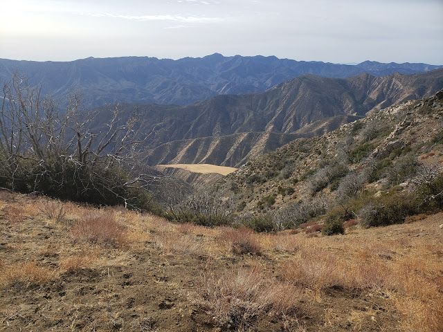
The Sierra Club says that the navigation along this part of the route is "difficult," but we found it to be pretty straight-forward. At one stage, we wandered slightly off-track, going too low on the northeast flank of Pt. 6,408, but we quickly righted ourselves by making a steep climb back to the ridgeline which has expansive views of Hot Springs Canyon and the Sespe Creek drainage. We then traversed one final minor bump and made the steep climb to the summit. 


San Rafael Peak Route
Going Off the Grid

San Rafael Peak Route
Dragon's Back

San Rafael Peak
St. Raphael

Hot Springs Canyon
Home of Hot Springs

Atop San Rafael we had 360-degree views of the entire Ventura County backcountry. Cobblestone, Topa Topa, Devil's Heart, Hines, Chief, Thorn Point, Haddock, Reyes, and Pinos are all clearly visible from summit. We logged our appearance in the summit register which dated back to 1974 and then lollygagged in the warm sun and tried not to share our snacks with a bunch of insistent hornets that magically appeared every time a plastic baggie or foil was opened.  

Then it was time to go. Days are short this time of year and light a precious commodity. We were well equipped with lighting, but really didn't want to have to rely upon it. So we retraced our steps back to the trailhead and began the long drive back to the reality of life in a pandemic. I can't say that this little adventure cured my pandemic blues or broke my writer's block, but as the old saying goes, "sometimes you just need to go off the grid and get your soul right." And my soul was right on this day. 

Cobblestone Mountain
Cobblestone Views

Devil's Heart Peak
Topa Topa and Devil's Heart

Summit Pano

Thorn Point
Thorn Point, Haddock and Reyes

San Rafael Peak Route
Going Back Home