~Isaac Asimov
Suck it up, cream puff!
~Captain Lee
I've spent a good amount of time over the past couple of decades exploring the backcountry of the southern Los Padres. I've also sat in my living room attentively pouring over maps of the Sespe, staring at peaks and trails and rivers and canyons and ridgelines and fantasizing about what it would be like to experience those abstract places that exist only on a Tom Harrison map and in my fertile imagination. Because of this, I've known for some time about Hines Peak and it's slightly shorter neighbor, Creampuff. I had just never actually been to either of them. This dereliction of exploratory duty certainly wasn't due to my disinterestedness. Instead, it was primarily the result of the challenge of actually getting to these two peaks which sit in a rather difficult-to-access corner of forest. The only two ways to reach these peaks is either by a very long and tortuous walk or, a long and tortuous drive along the Nordhoff Ridge Road to Elder Camp near the road's junction with the Red Reef Trail (permit and 4-wheel drive required).
But as Isaac Asimov said, true delight isn't in the knowing. It's in the finding out. So when Keith (aka, the Iron Hiker) suggested that we drive to the end of the Nordhoff Ridge Road in his 4x4 Tacoma, and then scale both Hines and Creampuff, I jumped at the opportunity. Time to be delighted.
Rose Valley and the Nordhoff Ridge Road
We met at Rose Valley early. Sean (aka Cucamonga Man) and Cecelia joined us there and we all piled into Keith's truck. As we began the long drive up 5N42, the marine layer hung thick and low in the air, blanketing the hillsides with an ethereal mist and obscuring the path forward. At one stage, the cloud-cover became so dense that I had to get out of the truck in order to tell Keith where the road was.
After a slow, bumpy, and foggy drive, we found a place to park just beyond Elder Camp and began our hike. At road's end, where the fire road intersects with the Red Reef Trail coming up from White Ledge, a couple was camped on a broad flat with magnificent views into upper Lion Canyon and the Sespe. Here, the mist finally began to burn-off as we climbed into the Thomas Fire burn zone which scorched this area in 2017. A Poodle Dog orgy was in full swing here, so we had to bob and weave and dance our way around the offending bush until it petered out near the saddle that separates Lion Canyon to the north and Santa Paula Canyon to the south. Here, we caught our first glimpse of the day's objectives piercing the pillowy cloud bank.
The Climb to Hines Peak
The route up Hines begins at the shallow saddle between Hines and Pt. 6,403. The Red Reef Trail continues in a south-easterly direction dropping down to Ladybug trail camp and then continuing all the way to the Sespe where it intersects the creek near Oak Flat. Recent reports indicate that this trail is passable from Oak Flat to roughly the old Horsethief site. But between there and Ladybug, the path is apparently a tangle of overgrown brush that is difficult to follow. No bueno.
The Route up Creampuff
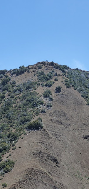
Cucamonga Man and Cecelia weren't feeling Creampuff, so Keith and I hurried ahead to tackle our second peak. Along the way, we passed the old Last Chance Trail which is mostly abandoned, but can still be seen coming up from Santa Paula Canyon. The route up Creampuff is very similar to the route up Hines, but steeper and looser. Much of the time, the process was two steps forward, one step back as the ground moved continuously beneath our feet. Fortunately, it's a shorter climb - a mere 400' in elevation gain - and before long, we were atop the summit where we found a summit register and the lid of a cream puff container to mark the spot. Trolling through the register of this "Seldom Visited Site" we recognized a number of entries from Los Padres regulars, including Christopher Lord (Lost in the Los Padres) and Reece McCalister aka Red Tail aka Mupu Mac aka the Lost Padres Lost Boy. This is a superior summit to Hines in terms of views. From this 6,486' aerie, you get panoramic looks at Hines, the Topatopoa Bluffs, and all points south.
How Creampuff Got it's Name
It is worth noting that the appellation "Creampuff" is not the actual, recognized name of this peak. In fact, I don't believe that it actually has a formal name. Which got us to thinking: how did this peak become colloquially known as "Creampuff?" David Stillman pondered this very same question and surmised that two guys christened it "Creampuff" after scaling it with a bag of weed and a container of Costco cream puffs. When I put the question to Bardley Smith, Los Padres legend and sawyer extraordinaire, he told me: "I thought it might be a case of Occam's razor. This was verified by legendary hiker Kim. C. As you found, the register is contained in a 'cream puffs' container." So there you have it. Mystery solved.
Back at the saddle between Lion and Santa Paula Canyon, I realized that I neglected to drink the summit beer I had brought along for the occasion. So I dug that out of my pack while the rest of the crew drank more healthy, but less enjoyable hydration alternatives. Then we all trudged back to the trailhead through the Poodle Dog minefield and the dense fog to end a truly delightful the day in the backcountry.


