Showing posts with label San Antonio Canyon. Show all posts

Sunday, December 16, 2018

Looking for Lookout Mountain


If I throw myself off Lookout Mountain
No More for my soul to keep
I wonder who will drive my car
I wonder if my Mom will weap
~Lookout Mountain, Drive By Truckers

The other morning, I found myself out in Pomona during the work-week which is not a typical occurrence. So after taking care of business, I decided to leverage the unusual situation and go hunting for an alternate cross-country route to Lookout Mountain that David R and dima, two characters I know, had blogged about on the San Gabriel Mountains Discussion Forum. I don't know whether I was doing the route correctly or not, but I didn't achieve the objective. So at least on one level, I was doing it wrong. On the other hand, you really can’t do the outdoors “wrong,” especially when the alternative is sitting behind a desk.

I parked in the village in front of the visitor's center and started up Bear Canyon. Along the way, I admired the quaint cabins and day-dreamed about what daily life was like there. I followed the road until it became a footpath and then followed that to the point where it begins the short series of switchbacks climbing eastward just below where the last two cabins in the canyon are situated. Immediately adjacent to this spot, a lateral drainage enters the main canyon from the west. Here, I crossed the creek bed and started up the drainage which had been traveled by others as I saw blue tape and rock cairns along the way. So I figured if I wasn't on the right route, at least I was on a route.

I rock-hopped up the drainage to a point where a subsidiary drainage entered from the west. I figured this couldn't be the right drainage because it appeared too narrow and its entrance obstructed with deadfall. So I continued my up the "main" channel passing and posing for a trail cam mounted to a tree along the way. Beyond that point, I noticed that the blue tape and rock cairns had disappeared. Ignoring that, I pushed on and finally came to a dry waterfall that was probably 20 feet high. The falls were climbable and there appeared to be a steep bypass on the right, but since I was solo, I figured discretion was the better part of adventure and so I turned tail here. I also reasoned that there was a good chance I was on the wrong trajectory anyway, so I backtracked to the junction with the subsidiary canyon and began my way up that drainage instead. 


"Lookout" Canyon

Ascending the Main Branch


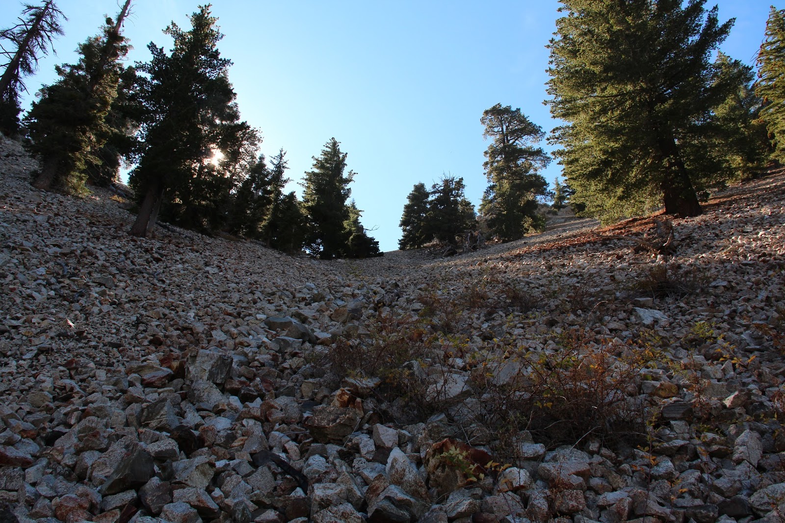
The Main Branch After the Split

Waterfall Obstacle
Ascending this drainage, I saw signs of travel by others so I was optimistic I was now where I was supposed to be. There was deadfall and rocks to negotiate, but nothing insurmountable. Then I came to a huge tree that had fallen across the creek bed. This is where I think things went awry. Instead of going under or around this tree and continuing upward in the channel, I climbed on top of the fallen behemoth and used it to cross to the south side of the gully as the going looked easier there. And I saw discernable signs that others had done the same. So I left the drainage and began ascending the steep, forested slope, following in the footsteps of previous visitors as best as possible.

But where others had been was apparently not where I wanted to be. As I neared what appeared to be ridgeline leading north from Pt. 5696, the brush got thicker. Then it became an impenetrable wall at every turn so I finally abandoned the fool’s effort. Reflecting on it now, I probably should have made my way back to the channel and continued upward, but figured I'd save that for another day. Marveling at how much easier it was descending then ascending, I retreated back to the main trail and decided to go to Bear Flats to see if I could locate the beginning of another fabled cross-country route to Lookout Mountain. 


Mouth of the Lateral Drainage

Drainage Ascending to the Saddle Just North of Pt. 5696
Bear Flats seems like a misnomer to me. I didn't see any bears and it’s not particularly flat. I also didn't see any trace of a use trail that could be used as an access point for a cross-country route to Lookout Mountain. All I saw was more brush. Since I’d already had enough of that for the day, I found a rock to sit on and have a snack while I licked the wounds to my ego and contemplated my navigational loserdom.


View South from the Bear Canyon Trail

Ontario Peak Dressed in Winter Finery

The LBC from the Bear Flats Trail

Saturday, November 12, 2016

Falling Rock Canyon

Lower Falling Rock Canyon
Falling Rock Canyon is one of those places that I felt the entire local hiking community had visited except me. I had looked at it on maps and glanced at it numerous times on my way up Icehouse Canyon, but I had never ventured into its rugged and shady depths. Some other peak or destination always took precedence. So last weekend I decided to fill that embarrassing gap in my San Gabriel Mountains experience. There's a ton of good route descriptions on-line so I'll dispense with that. To paraphrase Cracker, what the world needs now is another route description, like I need a hole in my head.

I rolled into the parking lot at Icehouse late to find it packed to the gills as usual. To my great fortune, however, there was an open spot right of front which I dutifully snagged. A good omen. Out of the car and up the trail that was heavy with weekend warriors like myself, I broke ranks with the herd just beyond the first switch-back and dropped into the stream-bed. There I was compelled to pause for a moment to absorb the colorful foliage and listen to the water music from Icehouse Creek. Leaf litter littered the ground and obscured the faint path forward, so I just aimed for the obvious gash in the side of the canyon whose entrance was choked with fallen rocks. Yeah, this had to be the way.

Icehouse Canyon

Sunburst in the Forest

Entrance to Falling Rock Canyon
Once in the confines of the canyon, I quickly encountered the first and second dry waterfalls. After a false start that left me more exposed than I was comfortable with, I gingerly backtracked a bit, tacked left, and then ascended some scree before rejoining the canyon above the second falls. Here, the narrow canyon climbs steadily up before moderating some in its higher reaches. This is a really an enjoyable stretch, one of the nicer places I've been in the San Gabriels, so I slowed my pace here as I picked my way through the rocks. I was only going as far as Sugarloaf so there was really no need to rush things.

The route descriptions I had read told me that I would ultimately exit Falling Rock Canyon on the right at the first scree field. Cairns marked the spot I was told. In short order, I came upon a cairn at the base of a steep slope coming in from the right that I told myself could be characterized as a scree field. Looking at the hillside, it was evident that folks had either been up or had come down here so I surmised this was the exit point. Thus, I began to climb but with some uncertainty.

The sledding here was tough. The angle was very steep. The rock was loose and crumbly. And every two steps forward resulted in one step back. I soldered on for about 20 minutes and then stopped to take stock of the situation. This didn't feel right. Either everyone else is more capable than me (which I admit is a distinct possibility), or I had taken a wrong turn. So I slowly made my way back into the canyon bottom resigned to the possibility that I might not make it to Sugarloaf.

But the day was still relatively young, and I was already here, so I figured there was no harm in continuing up the canyon just to see what was there. After rock-hopping for a bit in the slowly narrowing canyon, a bigger and more defined scree field spilled in from the right. There was no cairn to mark the location, but looking up it appeared to top out at a saddle. With nothing to lose, and a new belief that this must be the place, I began picking my way up the rock pile.

As it turned out, this in fact was the place. After a relatively short but steep rock slog, I topped out at a saddle between Ontario Peak and Sugarloaf. Here, a distinct use trail veered northwest toward Sugarloaf and the southern ridge route to Ontario was in view. I stopped to take in water and peer into the deep recesses of Cherry Canyon.

Lower Falling Rock Canyon

Looking Down Falling Rock Canyon

The Correct Scree Field

Use Trail to Sugarloaf

The North Side of Ontario Peak

Mt. Baldy from the Saddle

View South Into Cherry Canyon
From the saddle, it was just a short hop, skip, and jump over a false bump or two to Sugarloaf. On the flat, rocky summit I found a well-maintained register which I dutifully signed. Flipping through the pages I saw several names I recognized. Hikerhodi was in there several times. Dima Kogan had logged in after scaling Ontario Peak from Cascade Canyon. Feeling inferior, I put the register back in its canister home and enjoyed the fine scenery that Sugarloaf affords. To the northeast, the 3 Ts were plainly in site. Telegraph Peak loomed particularly large. To the northwest across Icehouse Canyon, Mt. San Antonio dominated the skyline. And to the south, was a unique look at Ontario Peak.

After lazing about for awhile, I picked myself up and made my way back to the saddle. Then it was a quick scree-ski into the shade of Falling Rock Canyon and a rock-hop back to Icehouse. In the car and out of San Antonio Canyon, I realized the Claremont Craft Ales was conveniently and dangerously nearby. So of course I made a visit to sample their Grapefruit IPA before calling it a day. For you beer aficionados, Claremont's Grapefruit IPA is decent, but I'd personally use a lighter hand on the grapefruit if I was brewing. I did sample their Mosaic Dry IPA which I found to be exceptional. I'll probably order that on my next visit. Cheers!

Upper San Antonio Canyon
The 3 T's - Thunder, Telegraph, and Timber

Ontario's Peak's North Side

Mt. San Antonio, Up Close and Personal

Telegraph Peak 

Grapefruit IPA at Claremont Craft Ales