 |
| California Poppies
Gilbert: I just wanted to say that I'm a nerd, and I'm here tonight to stand up for the rights of other nerds. I mean uh, all our lives we've been laughed at and made to feel inferior. And tonight, those bastards, they trashed our house. Why? Cause we're smart? Cause we look different? Well, we're not. I'm a nerd, and uh, I'm pretty proud of it.
Lewis: Hi, Gilbert. I'm a nerd too. I just found that out tonight. We have news for the beautiful people. There's a lot more of us than there are of you. I know there's alumni here tonight. When you went to Adams you might've been called a spazz, or a dork, or a geek. Any of you that have ever felt stepped on, left out, picked on, put down, whether you think you're a nerd or not, why don't you just come down here and join us. Okay? Come on.
Gilbert: Join us cause uh, no one's gonna really be free until nerd persecution ends.
~Revenge of the Nerds (1984) I remember the first time it dawned on me just how much I was missing when I began moving across the land on a bicycle instead of in an automobile. At 60 miles per hour, you see the forest but you miss the trees. On a bike, time slows down and space constricts revealing surprising and wonderful details about the landscape that otherwise would go unnoticed. Getting out of the car and onto a bike is like stepping up to an image that from afar looks like the Mona Lisa, but upon closer scrutiny reveals that is actually a mosaic of a thousand miniature images of George W. Bush.
That effect and realization were amplified when I climbed off the bike and started exploring my surroundings as my creator (whoever and/or whatever that might be) intended: on two feet. Crawling slowly across the land like an insect instead of rolling over it on two wheels, I was able to see and hear slices of life and evidence of the geologic and historical past that I’d completely missed before. The shed skin of a rattlesnake. Camouflaged scorpions the color of dirt. Fossils of ancient sea creatures embedded in sedimentary rock. A tarantula hawk dragging a tarantula carcass to its nest. A fox slipping silently into the trail side brush.
From another perspective, my understanding and appreciation of the local biota also came into sharper focus after I began my campaign of botanical disobedience. I suddenly noticed the incredible richness, diversity, and vibrancy of the plant community that makes up the chaparral ecosystem. Far from being uniformly dull, dry, prickly, and generally brown, I discovered that this native plant community is colorful, vibrant, varied, and incredibly compelling. Fascinated by this realization, I embraced my inner nerd and began in earnest trying to identify some of the plant life I was seeing. Beyond wanting to understand something about the land that I use with a high degree of frequency, I wanted to know who the interlopers were. I wanted to know who belonged and who didn’t.
So I started taking photographs of interesting or beautiful plants I was seeing. Then I’d come home and scour the Calflora website in hopes of making an identification. It’s not as easy as I thought. There’s a bazillion plant species that grow in Southern California and subtle differences in color, flower size, flower shape, leave configuration, elevation, and geographic location can make a definitive identification challenging. Then of course there are sub-species that look exactly alike which adds to the complexity of the whole affair. Finally, the pictures posted online never look exactly like the plant I’m looking at. Either the color is off or the angle is weird or the lighting is different or the perspective is dissimilar or the photograph was taken during a different season or whatever. So there’s always a margin for identification error.
Heading into mid-summer, I would have thought that the blooming season was pretty much over. But despite the lack of moisture, there’s actually still a lot going on out there. If you look, you’ll see that the hills are still dotted with yellow and red and orange and purple and and pink and white and green. Below are examples of a few of the natives that I’ve come across recently. Yeah, I’m a nerd, and uh, I’m pretty proud of it.
Blue Elderberry is a shrub that is native to California. It is recognizable by it blue-to-dark purple berries that appear mid-summer. The native Chumash are reputed to have used its hollow branches for clapper sticks. I always scrunch some leaves between my fingers when I pass an Elderberry so I can smell their wonderfully nutty aroma.

The beautiful and delicate Plummer’s Mariposa Lily is both native and endemic to California. It effectively exists only in 5 counties in Southern California: Ventura, Los Angeles, San Bernardino, Riverside, and Orange. Calflora categorizes it as rare on account of its limited range. If you live in one of those counties, go see it now. It’s going off.

Soap Plant or Soaproot is a perennial herb native to California. It is not endemic to California, but its range doesn't extend far beyond the Golden State's borders. You'll know this plant by its spindly appearance and startling white flowers. The native Chumash peoples used this plant to make soap and brushes. They also stirred crushed bulbs of this plant into pools which stupefied fish that then floated to the surface.
Narrow-leaved Milkweed is probably the single-most important plant for Monarch butterflies. The plant plays host to Monarch larva which consume the plant before they pupate. Narrow-leaved Milkweed is native to California, but not endemic, although its range is limited to the western United States.

Also known as Prostrate Spurge, Smallseed Sandmat is an odd little plant with an ugly name, but beautiful white flowers and vibrant green leaves. The plant, which oozes a sticky white substance, likes dry and/or sandy areas. Native peoples apparently applied the plant to scorpion and snake bites and chewed its roots to promote vomiting, to loosen bowels, and for stomach troubles. Smallseed Sandmat is native, but not endemic to California.

Another native to California, the Chaparral Bush Mallow is a shrub commonly found in the chaparral ecosystem. It has violet, cup-shaped flowers and irregular green leaves. Chaparral Bush Mallow is not endemic to California, but one variation (nesioticus) is a rare plant that is endemic to Santa Cruz Island and is federally listed as an endangered species because only approximate 120 individual plants remain.

This bright-red, gorgeous beauty loved by hummingbirds for obvious reasons has a darker side. Native peoples are reputed to have used the roots of this plant, and its cousin, Blue Larkspur (Delphinium parryi) to drug their opponents and poison cattle. They also used the flowers as a remedy for head lice, scabies, and other conditions. Scarlet Larkspur is native, but not endemic to California. It is blooming right now so go see it!

Cardinal Catchfly is another strikingly dramatic, crimson beauty that is currently in bloom. This perennial herb, with its distinctive starburst flower, is native to California. The "catchfly" name derives from the sticky, hairy glands on the stem and leaves that occasionally traps unwary insects.

Also known as the California Desert Peony, Sacapellote is a native herb endemic to Southern California. It is typically found on shrubby and wooded slopes, and is prominent after fires. You'll know this plant by its clustered pinkish/purplish flowers which alternate with white, fuzzy bristles (referred to as pappus). After the petals drop, seeds are disbursed when the pappus are carried away by the winds.

Sometimes referred to as the Woolly Sunflower, Golden Yarrow is a late-spring/summer blooming shrub that is native to California. It's striking, golden flowers form a tightly clustered dome atop an erect stem. Golden Yarrow can be found from the San Francisco Bay Area to Baja and in a variety of plant communities from chaparral to coastal sage scrub to southern oak woodland. Ladies and gentlemen, I give you the fantastic Golden Yarrow.

Known by its alternate name, Slender Tarweed, this ubiquitous annual herb is native to California, although not endemic. Often found in dense populations, this sun-loving plant is one of several that gives the Southern California hills their golden hue. From an ethnobotanic standpoint, tarweed was used by the native peoples of Santa Barbara, Ventura, and Santa Ynez to make pinole, one of their staple foods. Tarweed roots were also eaten by the Miwok who considered it an important part of their diet.

This is one of my absolute favorite plants. It's so distinctive, and weird, and chalky. Aptly named for its coating of powdery surface wax that reflects light and acts as a water repellent, this California native is typically found growing on steep, rocky slopes where fog is common. You can find the Chalk Dudleya outside of California, but it is confined to Western North America. Sorry East-coasters.

This is another odd, but interesting plant. Rub it's hairy leaves between your fingers and then smell them. Gross! A member of the mint family that also goes by the name terpentine weed and camphor weed, this plant's name derives from the strong vinegar-like odor it emits. The unpleasant smell is propionic acid, a phytotoxin that the plant releases to kill or injure competing plant species. This bad-smelling boy is native to California, but not endemic. But if you want stinky fingers, you'll have to travel to western North America because is isn't found beyond there.

Yerba Mansa is unique among this group of plants in that it is an aquatic perennial herb that is only found in an around wet creek banks and ever-wet cienegas. Given the aridity of Southern California, it's distribution is therefore necessarily limited. A native to California, Yerba Mansa was an important plant to a number of tribes California, the Great Basin, and the Southwest who used its root for medicinal purposes. Even Spanish settlers to California recognized Yerba Mansa's healing properties and used it as a linament for skin problems and as a tea for blood disorders. You'll know Yerba Mansa by its pretty white flowers, gigantic green leaves, and conehead-like protuberance.

Caterpillar Phacelia is an annual herb that is native to California. It's coiled, hair-like structures (inflorescence) which resemble a caterpillar make this plant unmistakable. This particular species of phacelia (there are many) can be found, sometimes in very large populations, mostly in chaparral communities, and frequently in burned areas or on rocky slopes.

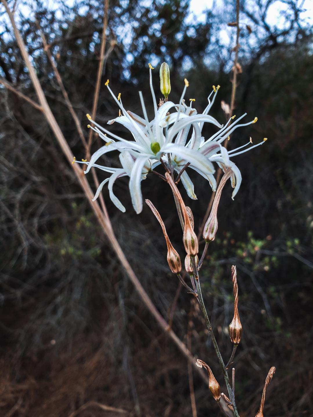
When we were kids, we used to say "first the worst, second the same, last the best of all the game." We said that when we got chosen last for whatever activity we were doing to convince ourselves we weren't total losers. Of course, it wasn't true in those instances...we were total losers. But in this case, that is certainly not the case. The stunningly gorgeous Humbodlt Lily is indeed "best of all the game." I've always called these beauties "Tiger Lilies," but I've discovered just recently (with a nudge from a couple of knowledgeable Instagramers) that the "Tiger Lily" is a distinct species of lily (there are actually two tiger lily species, the California Tiger Lily and the Sierra Tiger Lily). This native and endemic to California, which is loved by hummingbirds and swallowtail butterflies, is categorized by Calflora as rare based upon it's limited geographic distribution.
 |

Sunday, July 7, 2019
Embracing My Inner Nerd
Saturday, June 1, 2019
Better Living Through Nano-Aggression
 |
| Wild Mustard on the Long Canyon Trail |
After the rainy season was over, Southern California experienced a so-called “Superbloom.” This is when native wildflowers which have lain dormant during the long, brown months of fire and drought, suddenly germinate and explode in a technicolor orgy of orange, purple, blue, and red. And we all stampeded into the hills to appropriately “ooh and aah” at the wonderful spectacle of it all. In the process, we managed to trample under foot, leg, arm, and ass a good deal of the delicate wonders we all rushed out to admire. Then the dying time arrived and the warm spring sun bleached the hills from green to gray to straw yellow.
As that transformation was happening, a second “Superbloom” was under way. Unlike the first bloom, this one was not sugar and spice and everything nice. Instead, this bloom heralded the arrival of Black Mustard (Brassica nigra), a pleasant-looking but pernicious organism that metastasizes like a stage 4 cancer cell. No one ran to the hills to gape and gasp at this bloom even if they wanted to. The Black Mustard infestation became so thick that entire trail networks disappeared under a heavy blanket of yellow flowers and tall, woody stocks.
Black Mustard is a nasty plant that grows aggressively in disturbed and burned areas. It’s an early-germinating water hog with a deep tap root that releases allelopathic chemicals into the soil which prevent native plants from developing. It is not native to California and there are various competing explanations as to how it got here. One theory is that it was introduced by Franciscan padres who deliberately scattered its seeds along the El Camino Real to mark the way as they trudged northward between missions. Another story postulates that the plant was brought to California by Spanish colonizers as a spice crop which then quickly got out of control and spread like wildfire. Still another theory is that Spanish Rancheros introduced the species to support cattle grazing. The fast-growing mustard, the story goes, was deliberately planted to compensate for diminishing native grasses that were being rapidly consumed by the four-hoofed locusts we call cows. I don’t know which theory is the most accurate. They all sound plausible to me. But I think it safe to assume that indigenous Californians are not the ones responsible for this pest. It was brought here by colonizers and settlers and we have them to thank for it.
One look at the mustard-covered hills and you immediately know it is with us to stay. Given the sheer scope and magnitude of the infestation, it is pure folly to believe that it can be eliminated from the environment either now or in the future. I know and accept that truth. Nevertheless, I started randomly pulling mustard trailside here and there while I hiked as a cathartic exercise. They come up surprisingly easily if the soil is not compacted. I wasn’t really making a dent in the problem, but I figured getting rid of a plant here and there was a small contribution that I could make. Then I hit upon something. I could never win the war. I couldn’t even win a battle. I was far too outnumbered for that. But I could win small skirmishes. If I focused my attention microscopically on one small plot or one choked-out native, I actually could rack up some victories.
 |
| Before |
 |
| After |
So I commenced my insurgency against Brassica nigra in earnest. I’ve added
gardening gloves to my day-pack as the “11th essential,” and now
each time I go out, I pick a small area to clear and start yanking. I don’t
focus on the walls of mustard that flank every fire road. That’s a useless
endeavor. Instead, I’m focusing my attention on small sections of hillside or
individual native plants that are being crowded out.
The looks I get from passer-bys are hilarious. They’re not sure what to make of me. They’ve all got this “what in the actual fuck is this lunatic doing?” look on their faces. I’ve seen some of them shaking their heads to themselves. My family understands me by now. They fortunately tolerate my idiosyncrasies.
So there you have it. Me and Sisyphus both rolling our boulders uphill. It’s an endless and impossible task, but it’s oddly gratifying. And it is effective, albeit on a micro level. I’m fine with that even if the task will never be complete. It's what I call better living through nano-aggression.
 |
| Before |
 |
| After |
Sunday, December 16, 2018
Looking for Lookout Mountain

If I throw myself off Lookout Mountain
No More for my soul to keep
I wonder who will drive my car
I wonder if my Mom will weap
~Lookout Mountain, Drive By Truckers
The other morning, I found myself out in Pomona during the work-week which is not a typical occurrence. So after taking care of business, I decided to leverage the unusual situation and go hunting for an alternate cross-country route to Lookout Mountain that David R and dima, two characters I know, had blogged about on the San Gabriel Mountains Discussion Forum. I don't know whether I was doing the route correctly or not, but I didn't achieve the objective. So at least on one level, I was doing it wrong. On the other hand, you really can’t do the outdoors “wrong,” especially when the alternative is sitting behind a desk.
I parked in the village in front of the visitor's center and started up Bear Canyon. Along the way, I admired the quaint cabins and day-dreamed about what daily life was like there. I followed the road until it became a footpath and then followed that to the point where it begins the short series of switchbacks climbing eastward just below where the last two cabins in the canyon are situated. Immediately adjacent to this spot, a lateral drainage enters the main canyon from the west. Here, I crossed the creek bed and started up the drainage which had been traveled by others as I saw blue tape and rock cairns along the way. So I figured if I wasn't on the right route, at least I was on a route.
I rock-hopped up the drainage to a point where a subsidiary drainage entered from the west. I figured this couldn't be the right drainage because it appeared too narrow and its entrance obstructed with deadfall. So I continued my up the "main" channel passing and posing for a trail cam mounted to a tree along the way. Beyond that point, I noticed that the blue tape and rock cairns had disappeared. Ignoring that, I pushed on and finally came to a dry waterfall that was probably 20 feet high. The falls were climbable and there appeared to be a steep bypass on the right, but since I was solo, I figured discretion was the better part of adventure and so I turned tail here. I also reasoned that there was a good chance I was on the wrong trajectory anyway, so I backtracked to the junction with the subsidiary canyon and began my way up that drainage instead.
 |
| "Lookout" Canyon |
 |
| Ascending the Main Branch |
 |
| The Main Branch After the Split |
 |
| Waterfall Obstacle |
But where others had been was apparently not where I wanted to be. As I neared what appeared to be ridgeline leading north from Pt. 5696, the brush got thicker. Then it became an impenetrable wall at every turn so I finally abandoned the fool’s effort. Reflecting on it now, I probably should have made my way back to the channel and continued upward, but figured I'd save that for another day. Marveling at how much easier it was descending then ascending, I retreated back to the main trail and decided to go to Bear Flats to see if I could locate the beginning of another fabled cross-country route to Lookout Mountain.
 |
| Mouth of the Lateral Drainage |
 |
| Drainage Ascending to the Saddle Just North of Pt. 5696 |
 |
| View South from the Bear Canyon Trail |
 |
| Ontario Peak Dressed in Winter Finery |
 |
| The LBC from the Bear Flats Trail |
Monday, November 19, 2018
Chamise, the Woolsey Fire, Fucked-Up Priorities, and Gratitude

As you may know from my last blog-post, I’ve effectively
adopted a little Chamise plant that lives in a fissure atop a sandstone
outcropping in the hills overlooking my neighborhood. For the past year or so, I’ve
fawned over this little guy like a doting parent, showering him with
attention and water and protecting him against foreign invaders intent on claiming
and occupying his homey crack. While other nearby plants have either withered
or retreated into dormancy during what seems like perpetual drought, mi chamisa has flourished. He bloomed
late into the season this year and is looking quite robust despite his rather harsh
and austere surroundings.
So when the Woolsey Fire raced through the area and ravaged
the local hillsides, I thought of mi
chamisa and was immediately sick with worry. I realize how quirky and perhaps
douchey it may sound to be worried about a single fucking plant while entire
neighborhoods and biomes are burning. But I’ve invested a lot of emotional
capital in this single plant, and rightly or wrongly, I was concerned about
him. If that makes me sound like a
crackpot with misplaced priorities, I suppose that’s only because I’m a
crackpot with misplaced priorities. I accept that.
So last Friday night, I raced home after work and scampered
up the familiar trail in the fading light to do a welfare check on my friend. As
I climbed the trail, a heaviness fell upon me. Both sides of the trail were
charred black and the odor of smoke still hung heavy in the air. Most of the
vegetation, including the despised Russian Thistle, had been completely obliterated
by the flames. The landscape was deathly still and devoid of life. I wondered
about the Western Toads I had inexplicably seen trailside before all hell broke
loose. I was astonished they were there in the first place. What could possibly
be their fate now?
Lost in thought and feeling a bit melancholy, I crested the
ridge to discover that the trail sign and wooden bench were still there and intact.
Stunned, I stood there for a brief moment trying to process what I was seeing.
Everything around the bench and trail sign was completely gone, but they were
still there. I hurried to the top of the hill where the sandstone outcropping
sits, approaching it reverentially and with some hesitancy. Now that I was
there, I wasn’t really sure whether I wanted to see what I had come to look at.
But I quickly noticed that the rounded top of this hillock seemed to have
avoided the worst of the flames. It was hard to tell for certain in the dusky
darkness, but I thought I could detect living, breathing plants as I made my
way up the spur to the summit.
At the base of the sandstone outcropping, I readied my flashlight and scurried to the top. Hesitating for a moment, I surveyed the cliff edge before turning on the light. I could see something in the darkness, but I couldn’t tell if it was alive or dead. I asked the universe for a miracle and then switched on the light. And there he was, mi chamisa, sitting there stoically in the sandstone crack as he always had, untouched by the flames.
I was overwhelmed by emotion. Tears began to well up
but I held them back. Nobody was around to see, but I still felt a bit embarrassed about getting weepy over a solitary plant. I texted my daughter 400 miles away to tell her that mi chamisa had survived. She responded immediately
with relief telling me that she had seen the destruction in the burn areas and
had been thinking about my Chamise. She is her father’s daughter. She has inherited my
idiosyncrasies.
I quickly pulled some water from my pack and offered some to my friend. He gratefully accepted. I then sat alone in the inky stillness sipping a beer and feeling content. Sometimes, the universe delivers.
Sunday, September 16, 2018
How I Became a Guerrilla Soldier in the War on Russian Thistle

There is a rocky sandstone prominence in the hills above my house that I hike to virtually every night. I generally pack some cheese and a can of beer and sit up on this outcropping to watch darkness creep over the landscape as the light dies in the west. My throne is pretty damn barren and inhospitable…it’s rock after all. But it is fractured and creased in places and some of those crevices collect and hold a bit of sandy soil.
In one of those crevices, life has implausibly taken hold. A solitary Chamisa has sprouted from the sandstone and against all odds, is somehow eking out an existence. I’ve become quite attached to this little Chamisa for some reason, and I’ll share some water with him occasionally to make sure he gets through the long, Southern California dry season. He’s my buddy, at least in my mind, and I’ve become obsessed with checking on his health every time I go into the hills.
One day when I went to visit, I noticed he had an unwanted neighbor. A Russian Thistle had taken hold in the crack and was threatening to hog all the water I provided and to crowd out mi chamisa. Furious, I yanked the invader from the crack roots and all and tossed it unceremoniously over the edge of the outcropping. It relinquished its hold in the crack surprisingly easily.
Russian Thistle, a non-native invasive, is pervasive in the hills of Southern California. I’ve always known it was there, but like Black Mustard, it is so ubiquitous and so integrated into in the landscape that I never gave it much attention. But after my clash with it on the sandstone outcropping, I took a hard look at the areas immediately adjacent to the trail leading to and from the prominence. The area is carpeted with the offending stuff. It’s easy to spot right now because it blooms in late summer-early fall and consequently is one of the few plants that is currently green.
That’s when it hit me. I was going to yank some of that shit out. I knew getting rid of all of it was a fantastic crack-pipe dream, a moron’s errand, but I figured eliminating it from portions of the trail was a battle I might be able to win. So, the following weekend, I bought sexy-looking black pick-axe from Lowe’s and became a guerrilla soldier in the war on Russian Thistle.
Later that night, I packed leather gloves, water, and beer into my pack, grabbed my new implement of death, and headed for the hills. At first, I was a bit reticent about hiking with a pick-axe, not knowing how folks would react. I thought maybe someone might challenge whether my removal of non-native invasives had been appropriately “sanctioned” by whomever it is that sanctions these types of activities. I got a few curious looks, but nobody said shit. I guess I looked official. In reality, I was just some beer-swilling dude with a fucking vendetta.

Since that day, I’ve removed thistle from the area surrounding the sandstone rock on which mi chamisa resides as well as the upper stretches of the trail leading to the outcropping. I honestly don’t know whether my efforts will have any positive effect, but I figure at a minimum, I’m giving space for native plants to sweep in and re-occupy the areas that were being hogged by the thistle. Beyond that, it just makes me feel happy and satisfied. And best of all, the crack that mi chamisa calls home remains Russian Thistle free.
Saturday, August 4, 2018
Chased Out of the Miter Basin
 |
| The Miter Basin |
I’ve got a Tom Harrison map of the Whitney Zone that I
unfurl now and then so that I can daydream about all of the nooks and crannies
on that map that I still need to visit. One of the places I’ve stared at and
imagined for a long time is the Miter Basin. Surrounded by an assemblage of
white granite peaks, spires, and domes, and dotted with lakes with names like
“Sky Blue” and “Iridescent,” I always found this trackless and relatively
remote area irresistibly alluring. And I wanted to visit it.
So I finally conceived a plan and convinced my daughter and
a friend from Utah to join me on a romp into the heart of the basin. The loose
itinerary involved a loop of sorts beginning at the Cottonwood Pass trailhead.
The plan was to spend the first night a lower Soldier Lake, a second night a Sky Blue Lake, and a third night in the Cottonwood Lakes Basin. We’d make the
short walk out and back to the car on the morning of the fourth day.
So on
a Wednesday afternoon we loaded up and headed for the Alabama Hills where we
car-camped at Tuttle Creek. The next morning we were up early for coffee and
permits. We didn’t actually have permits reserved, so we had to wait until the
Eastern Sierra Interagency Visitor Center opened at 8 a.m. for the lottery.
When we got there around 7:45 a.m. there was already a line of about 30 folks
doing the same. I sauntered up to the entrance and was innocently milling about
when a dude with his girlfriend barked at me for trying to cut the line. I told
the guy that there was no line, and that we’d all draw numbers from a hat to
determine our order. Shortly after that, a Ranger appeared with a bucket and made
me look like a sage. We then all drew numbers. I pulled number 3; the guy that
barked at me pulled something much worse. We got permits no problem. I don’t
know about the other guy.
 |
| Car Camping in the Alabama Hills |
Forty-five minutes later we were on the trail and making our
way up to Cottonwood Pass. If you’re an old man living at sea level, one of the
nice things about the trails departing from Horseshoe Meadow is that you’re
already at elevation. You of course still end up climbing with a fully-loaded
pack, but it’s a kinder, gentler climb that allows your body a bit of time to
acclimate to both the weight of the pack and the less oxygen-nutrient air.
At Cottonwood Pass, we paused briefly for snacks
and to snap pictures for a group that had spent a week or so making the circuit
around the Big Whitney Meadow area. We then jumped onto the PCT and made our
way to Chicken Spring Lake to tank up on water since it wasn’t evident whether
we’d have another chance before we reached lower Soldier Lake.
 |
| Horseshoe Meadow |
 |
| Cottonwood Pass |
 |
| PCT |
 |
| Chicken Spring Lake |
From Chicken Spring Lake, the PCT climbs briefly out of a
shallow cirque and then remains relatively level at about the 11,300’ contour
until it crests a low rise and begins a slow descent into the vast Siberian
Outpost. Here we stopped briefly to admire the stark landscape and the
interplay of sun and shadows being cast by storm clouds to the west. A
harbinger of things to come.
A mile or so beyond this is a well-marked trail junction.
Going south will take you up over the Siberian Pass and into the Big Whitney
Meadow area. Continuing west along the PCT leads to Rock Creek and beyond. We
veered north on the pleasant connector which ultimately intersects with the
path that leads east up over New Army Pass and northwest to lower Soldier Lake.
Just before that intersection, the connector crosses a stream which was running
strongly and could serve as a good source for replenishing water supplies. We
were still good in that regard, so we pushed on to our destination.
The spur leading to lower Soldier Lake is dotted
with campsites and a single bear box. There are additional sites immediately
adjacent to the lake as well, but we didn’t know when we first arrived. As we
inched along the spur, we were somewhat surprised to find that every single
site was occupied. One large site housed a group of ten 20-somethings from Ohio
State who told us they’d been on the trail for 26 days. The last site before
the lake was taken by a sole older gentleman who offered to split the site with
us. We gratefully accepted and shared our whiskey with him as recompense. Turns
out our camp host was enjoying his first night of a solo hike of the JMT. The
following day he was headed for Guitar Lake so that the day after he could
summit Mt. Whitney and officially begin his through-hike.
 |
| PCT Views |
 |
| Rock Field |
 |
| Siberian Outpost |
 |
| Connector to Lower Soldier Lake |
 |
| Camp View at Lower Soldier Lake |
The next morning we had planned to penetrate the Miter
Basin. The intended route was the “short-cut” which follows a use trail that
skirts the west side of lower Soldier Lake and then climbs the low rise on the
north-west end of the lake. Upon seeing the route, my daughter expressed a bit
of trepidation so we back-tracked to the main trail and tacked southwest to the
mouth of the Rock Creek drainage.
There is supposed to be an obvious use trail
leading up drainage, but it wasn’t obvious to us. We ran into a couple of young
ladies looking to do the same thing we were doing and we all fumbled around a
bit looking for the non-existent use trail. Finally, we forded Rock Creek and
began ascending the west side on something that kinda, sorta resembled a faint
use path or game trail. After bashing through brush for a bit and climbing
obstacles, our female companions apparently called it quits because we didn’t
see them again. Determined or obstinate, we continued forward for about ¼ mile
when we burst into a wide, open meadow bisected by Rock Creek. One the east
side of the creek, we finally saw the well-trod use trail we’d been searching
for and jumped the creek to beat its path.
 |
| Meadow Near Rock Creek Junction |
 |
| Rock Creek as it Flows Out of the Miter Basin |
 |
| The Meadow - Use Trail to the Right |
From here, the route forward was pretty simple: continue up
the basin. We occasionally lost then relocated the use trail, but it’s pretty
hard to get truly lost here as there is only one way in and one way out. Ok,
that’s not entirely true, but practically speaking it is for most mortals, and
that included us.
The scenery here is as sublime and glorious as I had
imagined it. The Major General sits high on your right. Mt. Corcoran, Mt.
LeConte, and the Shark Tooth, all 13,000’+ dominate the skyline to the
northeast. The spikey Miter scrapes the sky to the north. And an unnamed granite
spire and 12,000’ solid granite walls hem you in on the west. Our intended
destination Sky Blue Lake, sits in a bowl above a series of cascades sandwiched
between the Miter and Peak 13,221’.
But about ½ mile out, as we approached the final ascent to
Sky Blue Lake, the sky after which the lake is named became ominous. The wind,
which had been still throughout the day, began to howl. The temperature
dropped. We started to hear the crack of lightning and the rumble of thunder.
And then the heavens opened up and it began to rain. Then it hailed hard enough
to coat the ground with tiny balls of ice. Then it rained again, harder this
time.
We stopped to evaluate the situation and ponder the night
ahead. My trail companions looked dubious. My daughter, the more level-headed
of the two of us, was reluctant and urged retreat to lower ground. Dejected, I
relented and we started to beat a retreat back to Soldier Lake.
On the way out, we bumped into a young lady that
was part of the Ohio State contingent. She had gone into the basin on a day
exploration and was retreating to Soldier Lake as well. When we discovered that
she was returning via the “shortcut,” we stalked her all the way back to the
lake which in fact shaved off a fair amount of distance and time.
 |
| Granite Cliffs Abound |
 |
| Pushing Deeper Into the Basin |
 |
| Typical Basin Views |
 |
| Lower Soldier Lake from Atop the Shortcut |
Back where we started the day, we set up camp lakeside on
the peninsula of sorts that juts into the lake on its south side. As soon as
our tents were up, the rain began and we took shelter. And then it rained, and
it rained, and it rained. And it hailed again. And then it rained again. For
three straight hours, the rain relentlessly pummeled our sad little fabric
shelters which finally wetted out despite a valiant struggle to keep us dry. At
dusk, the precipitation finally subsided and the clouds gradually began to move
along and ruin someone else’s party.
The next morning was brisk and clear. We took our time
breaking camp in order to allow our gear to dry some. Then we were back on the
trail ascending the stunningly gorgeous valley that climbs to New Army Pass
from the east. As the climb stiffened, and the suffering began in earnest, the
beauty of my surroundings began to fade. Actually, the surroundings didn’t
change at all. It was just my frame of mind. The Buckeyes were in front of us,
and I tried to use them as my rabbit, but I couldn’t keep pace with the
youngsters, including my daughter who blasted the ascent with no problems.
Finally atop the 12,310’ pass, we stopped to refuel and to immerse ourselves in
the moment. It was chilly and breezy at the pass and billowy clouds were
starting to accumulate on the horizon.
The climbing for the trip complete, we descended the spare
cirque that cradles appropriately-named High Lake. A fair number of hikers were
struggling up as we came down, including a guy attempting to prod, poke, and
cajole a group of adolescent boys up to the pass. We offered encouragement, but
the boys just looked at us with utter contempt. I laughed because I knew how
they felt. At Long Lake, we stopped again to pump water and solidify our plans
for the evening. Charcoal gray thunderheads were now boiling up over the peaks
to the northwest and the skies to the east and south were darkening.
Remembering the onslaught we endured the night before, we determined to admit
defeat and walk the rest of the way out. Midway back it began to rain again.
Back in Lone Pine, we figured we’d salvage the
remainder of the trip by getting eats, beer, and firewood for another night of
car-camping at Tuttle Creek. But even here, the weather refused to cooperate.
While we were in town, the wind kicked up and the sky turned black. Lightning
cackled and thunder thundered in the distance. We knew our fate was sealed. So
we jumped in the car and made the long drive back to predictably and reliably dry
civilization.
 |
| Lower Soldier Lake Campsite |
 |
| Climbing to New Army Pass |
 |
| Approaching Near New Army Pass |
 |
| Mt. Langley from the New Army Pass Trail |
 |
| High Lake, Long Lake, and South Fork Lakes from New Army Pass |
 |
| Descending the East Side of New Army Pass |
 |
| Stunning Rock Formations |
 |
| Long Lake |
 |
| Cottonwood Lakes Basin |
Subscribe to:
Posts (Atom)